Check out this promotional video for Google Earth VR, the next mapping tool from Google’s cartographic tool-kit that I took interest in exploring for today’s final presentation. This video does a great job to act as springboard in generating discussion as well as thought about VR and technology in general toward mapping today and for the future. Worth checking out!
This interesting website (above) follows lightning activity across regions. Looking closer at the map one will notice how the majority of the southern hemisphere is not recorded, which leaves some outstanding questions as to why aren’t there any weather recording apparatus in those regions, and what that tells us about the conditions (socio-economic, political) of those areas.
An awesome website that I came across that has a collection of interesting city maps, as well as informational maps of that city based on crime, location, traffic et cetera. Definitely a site worth checking out.
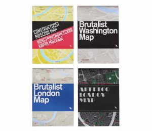
“As more and more examples of classic Brutalism face demolition by neglect, we hope that putting these examples of D.C.’s Brutalist architecture on the map will foster public appreciation that ensures their longevity, said Madsen. “
City Guide publisher Blue Crow Media and Deane Madsen, Associate Editor of Design at Architect Magazine, have collaborated to produce the Brutalist Washington Map, which features 40 examples of Brutalist architecture in Washington, D.C. This is Blue Crowe’s fourth architectural guide map, following their Brutalist London Map, Art Deco London Map, and Constructivist Moscow Map. One can only expect further releases on the horizon.
For further reading and interest of this article please reach the link below.
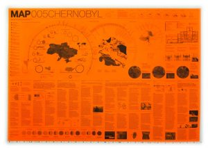
Check out the website: http://davidgarciastudiomap.blogspot.ca for more maps by MAP (Manual of Architectural Possibilities). They released a variety of series, this one in particular was done in commemorating the disaster of Chernobyl, there are others on Floods, Quarantine, Antarctica et cetera. Each series is made as a pamphlet that displays infographics on varying issues on a given theme as well as a historical briefing.
If you find this type of representation interesting I would also recommend checking out the Toronto based firm Lateral Office at http://www.lateraloffice.com, their project Making Camp also uses the pamphlet as a representational style in nostalgia for local hiker and camping pamphlets that are traditionally used. Specifically you can find it here http://www.lateraloffice.com/MAKING-CAMP-2015.
Mei Fang Lao, Masters Candidate at the Bartlett School of Architecture.
PROCEDURE
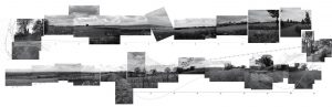
Students will engage the site through a series of recordings that analyze the impact of a particular phenomena on the condition of the site. Using the assigned transects, students will track the interferences that create deflections, deviations, or deformations in the volume and/or surface of the site. Students will use a notational language of mark-making to describe the force and trace of the interferences, rather than the forms. Each student will produce an analog mapping that tracks change over time along a single transect.
For further interest go to: http://lab.visual-logic.com/academia/la-4504-hybrid-analytical-representation/001-site-mapping/
MANY MORE DIFFERENT APPROACHES ON MAPPING IN CONTEXT TO THE ABOVE PROCEDURE AT THE BARTLETT SCHOOL OF ARCHITECTURE- TAKE A LOOK AT THE LINK FOR DIFFERENT PROJECTS.
This site above has a good collection of interesting and fun mapping projects that can help ignite some inspiration for the next project. It covers all kinds of studies from the map of Pangea to a more serious map of beer names in Europe.
When the Dutch arrived in 1634, they built forts at key points around the island to protect themselves from foreign powers, privateers, and pirates. Six of the best preserved forts can still be seen today: Waterfort (1634) Fort Amsterdam (1635) Fort Beekenburg (1703)[30] Fort Nassau (1797) Riffort (1828) Piscadera Bay Fort (built between 1701–1704).
To continue reading about the Dutch Forts and how they’re mapped visit the site noted above.
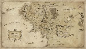
An interesting case study of how maps can generate a very realistic atmosphere within a fantastical world. The use of scale, direction, denoting mountain ranges and other sleight topography, as well as annotation all help add to the realism of this fantastic dream-made world.
 Follow