Georeferencing is a very important topic for both GIScientists and GISystem specialists. It is the means by which data from different sources can be integrated; without georeferencing GIS never would have been developed (as mentioned early in the course: geography integrates data). Furthermore, one of the more common sources of avoidable error in spatial analysis can be traced back to an improper understanding of georeferencing–using data that are referenced to different datums, selecting an incorrect map projection, etc. Luckily there are many sites devoted to georeferencing, so one can quickly become familiar with all of the different topics included within the framework of georeferencing. The principle topics that are usually included within an discussion on georeferencing are:
- Geodesy
- Map projections
- Coordinate Systems
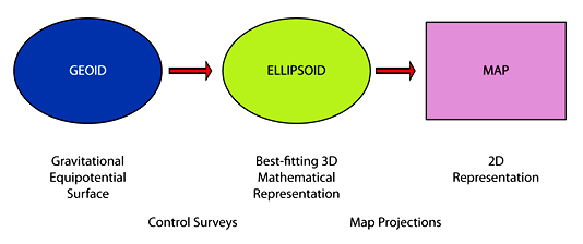
Fundamental to understanding map projections is first understanding how the earth itself is described–this involves understanding geodesy. The Federal Government has produced some educational materials related to geodesy and they provide a historical perspective on our views of the earth over time. Datums are the link between geodesy and map projections–on the Australian Geoscience site you’ll find detailed notes that describe geodetic datums and map projections. From a GIS perspective, coordinate systems follow from projections–each coordinate system is linked to a particular datum–map projection combination (what I refer to as a Projection-based coordinate system).
View Examples of Map Projections >>
Learning Objectives
- Know the requirements for an effective system of georeferencing;
- To become familiar with the problems associated with placenames, street addresses,
and other georeferencing systems used every day by humans; - Recognized how the Earth is measured and modeled for the purposes of positioning;
- Become familiar with the basic principles of map projections, and the details of some
commonly used projections; - Understand the importance of the need to transform between different systems of georeferencing.
Required Readings
Text: Chapter 4: Georeferencing.
Slides from the lecture are on Canvas.
Alternative text: Chapter 2.2 in GIS Basics provides an overview of coordinate systems and map projections.
Recommended Readings
Paul Cote has prepared these useful notes on Coordinate Systems, as well as some notes on Rectangular Coordinate Systems (the topics covered include rubber sheet transformations):
Useful Resources
Australian Government: Geoscience Australia - developed some wonderful materials–check out the section on Earth Monitoring and Reference Systems, and the subsections therein. You’ll find a good discussion on datums and coordinates.
Geographic Information Systems, First Edition, 1991 - Wiley (a textbook publisher) has made available selected chapters from the 1991 “Big Book” of GIS–chapter 10: Coordinate Systems and Map Projections for GIS is a thorough overview of the topic by D.H. Maling
A site that allows you to search for any official coordinate system in the world: EPSG.io and the organization behind those (European Petroleum Survey Group) efforts: International Association of Oil and Gas Producers (IOGP).
A good article on the need to ensure consistency in projecting layers, including the need for transformations between datums.
A brief reminder that (native) raster coordinate systems are different from (native) vector coordinate systems, presented from a Python perspective.
Wikipedia: Map Projections
Wikikpedia: Geoid
Wikipedia: Ellipsoid
Wikipedia: Cadastre
Wikipedia: World Geodetic System
And, for something completely different (in terms of georeferencing): What three words?
Keywords
PBCS, UTM, Projection parameters (surface orientation [normal, transverse], form [plane, conic, cylindrical], contact [tangential, secant]), Geoid, Ellipsoid (Ellipse), Datum (NAD27, NAD83), cadastre, WGS84 vs GRS80, Define projection vs Project
A definition of metric: met·ric2 (mtrk) ETYMOLOGY: Greek, (the art) of meter, feminine of metrikos, relating to measurement.
n.
A standard of measurement.
Mathematics. A geometric function that describes the distances between pairs of points in a space.