Brett’s blog

What I do, Up-Goer Five style

I recently challenged a class of graduate students to take on the UP-GOER FIVE CHALLENGE, in which they use only the ten hundred most common words in the English language to describe what it is that they do. Then I tried to describe what I do using the same. It got interesting in a hurry, and gobbled up far more time than it should have. However, I think it helped cut through to the essence of what we actually do at research universities in a way that more articulate prose does not. See
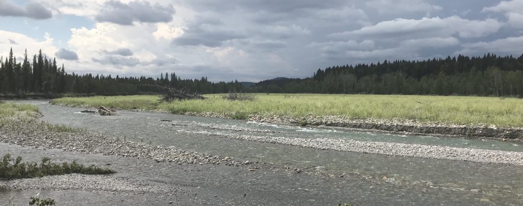
 what you think.

Brett Eaton, PhD, Up-Goer Five Style

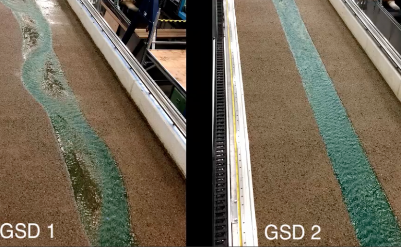
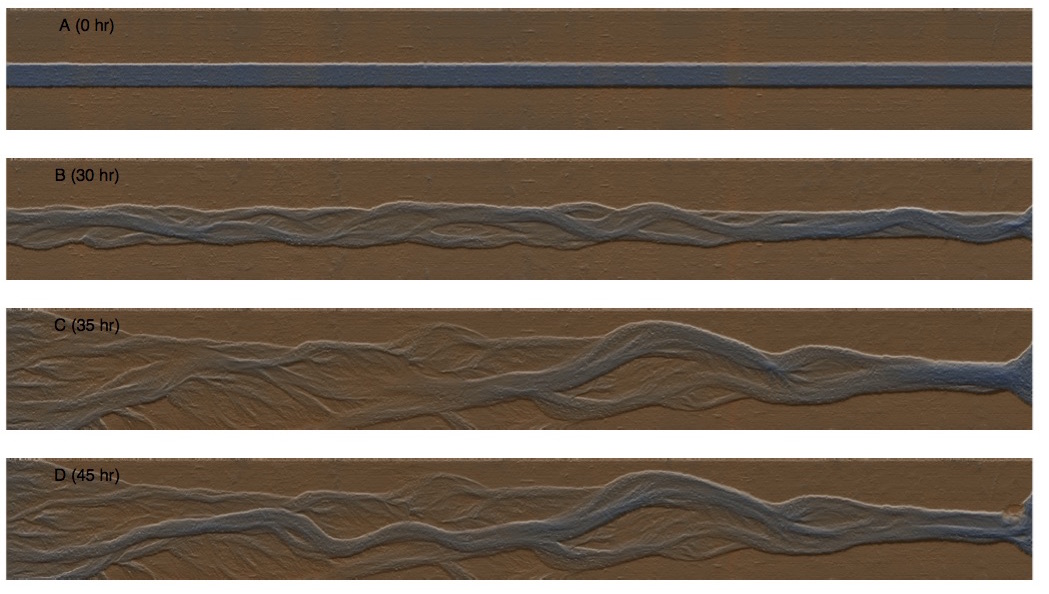
I am a middle aged person who studies water moving over the land. Many young people help me to do this. Together, we want to know more about how moving water changes the land, and how it can do bad things to those of us who live close to the water. We look at how fast the water moves, and how much land it can eat up and carry away. We want to know when the moving water can cause bad things, and how to build roads and houses and other things near moving water so that bad things do not happen to them. The bad things we think about are going to happen more next year, and the year after that, because the world is getting hotter and the air is getting wetter, making more rain in many places. The towns and cities we live in, and the roads between them, are not ready for a hotter, wetter world. We also want to know what the world changes will do to the animals and other things that live in the moving water. The young people I work with study moving water on the land, and in a building made to study moving water carefully. We also use boxes that add numbers and take numbers away to guess what moving water does on the land and in the building made to study them. All these ways of studying moving water make us better at guessing what will happen next year, and the year after that. This is much more fun for me than studying air moving around the world from one place to another, or studying things that grow on the land or in the water, but studying those things is important too. By putting it all together, maybe all of us working together can guess what will happen to everything in a hotter, wetter world. Maybe not. But it would be fun to try. That is why I work here, in this building, where all of us study something.

Large grains and channel stability

We recently ran a pair of experiments that demonstrates that channel stability is independent of the mobility of the surface median grain size (D50). The video above shows a time lapse for the two experiments. In both cases, the median grain size was fully mobile. However the largest sediment in the bed was fully mobile for one experiment (the one on the left) but only partially mobile for the other experiment (the one on the right). We analyzed these two experiments, and the results are presented in a paper recently accepted by Earth Surface Processes and Landforms.

We think the implications of this pair of experiments are potentially quite profound. While using the D50 as the characteristic size for analyzing sediment entrainment and  transport seems quite reasonable, we cannot make the tempting (though facile) assumption that the stability of a channel is associated with either the entrainment of the D50, or with full mobility of that size class. However, we do seem to be able to associate periods of significant net change in reach-average geometry and channel pattern with full mobility of the largest sediment sizes in the bed material.

One implication of this is that bed stability (and channel morphodynamics) may be fundamentally controlled by  the entrainment and transport of the largest grains on the channel bed, as is commonly assumed to be true for step-pool streams. Interestingly, many flow resistance laws have found a stronger correlation between mean velocity and a roughness measure based on grains larger than the D50 (like the 84th percentile of the surface grain size distribution), which may be linked to the role such grains play in stabilizing the channel bed.

Another implication is that small additions of coarser than average material may substantially alter gravel bed channel morphodynamics, promoting a more stable stream with a much lower bedload transport rate for a given flow. This fact could be exploited to develop new restoration techniques that do not rely on heavy handed engineering approaches. Conversely, removing a small fraction of the coarse tail of the bed material could dramatically increase the lateral activity of a stream, which could be exploited to help restore natural channel dynamics where flow regulation and development on the floodplain places a limit on the size of  floods that can be released to the stream.

Related Work

This paper by Masteller and Finnegan (2017) points out the significant role that bed state and grain protrusion play in controlling sediment transport rate, and could be closely related to our findings.

This research spotlight points out the role that large grains play in mediating sediment transport in steep streams.

Track changes with LaTeX

Many of us in academia have chosen to move away from word processing packages, using LaTeX to produce papers. There are a number of advantages to using LaTeX to produce written work, particularly if there are numerous, complex equations. I personally cannot stand using a standard word processor anymore, and get quite grumpy with co-authors who insist on dragging me into the world of Word, Excel and other hard drive- and system resource-gobbling programs. The major drawback to using LaTeX is the lack of a “track-changes” option. But, as always with open-source projects, there is an app for that.

Continue reading Track changes with LaTeX

Modelling Flood Effects on Gravel-Bed Channels

Filtered_DEMS_Exp_5
DEMs of an experimental run at the scale equivalent of 1.5 cumecs for 30 hr, 4.5 cumecs for 5 hr, and then 1.5 cumecs for an additional 10 hr.

At UBC’s BioGeoMorphic eXperimental Laboratory (BGMX Lab), we are running experiments on how steep cobble-gravel channels like those found on alluvial fans in mountainous regions respond to extreme flood events. The Adjustable-Boundary Experimental System (A-BES) allows us to create scale models of long reaches of river, to image those systems using high-precision laser scanning, and to analyze sediment transport patterns in great detail.

Continue reading Modelling Flood Effects on Gravel-Bed Channels

Using drones under a forest canopy

Catching a drone…

So we gave our nice new DJI Inspire 1 drone its first real survey job. About 10 seconds after take-off, the thing flew straight into a tree. Lesson learned: when working under a forest canopy, you may not have usable GPS coverage, in which case you can’t rely on the built-in stabilization magic that makes most drones easy to fly (in open areas, at least). One replaced propeller later, we were back up in the air, and managed to collect over 100 decent photos of a steep step-pool stream. With a bit of practice, the drone can be controlled reasonably well; with a lot of practice and an experienced operator, I imagine a drone could be made to dance amongst the trees like a butterfly.

Continue reading Using drones under a forest canopy

Surveying with UAV’s – a first glance

DCIM101GOPROG0092884.In April 2015, I got my first taste of surveying with an unmanned aerial vehicle (UAV). With the guidance of Jon Tunnicliffe at the University of Auckland, we conducted a number of surveys of river reaches on the East Cape of the North Island, New Zealand. These rivers are amazing for their level of geomorphic activity, but the capacity of even a simple UAV system to develop a detailed topographic model of a river reach was equally impressive.

Continue reading Surveying with UAV’s – a first glance

Spam prevention powered by Akismet