Index of Ecological Importance

T O P I C   O V E R V I E W

This week I decided to read a selection of the book “Sustainable Infrastructure : The Guide to Green Engineering and Design” by S. Bry Sarte. This reading investigated  applications of sustainable infrastructure and explored several case studies in order to demonstrate these applications. I found the case study of development on Isla Pedro Gonzalez (known locally as Pearl Island) in the Gulf of Panama to be particularly interesting. As the book discusses, islands make great examples for sustainability case studies as it is easy to see and appreciate that resources are limited, and to define the system boundaries. One can clearly observe the effort required to transport resources to and from the island, and see the trash piling up on the island’s beaches and in surrounding waters.

Pearl Island is unique in that a master plan for development on the island was developed by a team of local residents and stakeholders, engineers, ecologists, architects, and community planners prior to significant human habitation, development, and use. This allowed the island to be developed sustainably from the ground up with all environmental factors considered, without having to modify an existing poorly developed site. Many interesting and useful design strategies were employed in throughout the development of the master plan and are discussed at length in the book. However, I found the idea of an “Index of Ecological Importance” particularly intriguing.

capture2

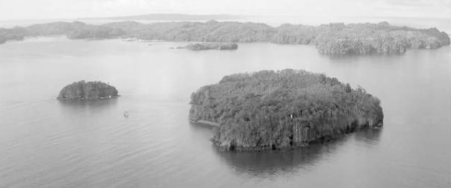
Figure 1: Looking out towards Isla Pedro Gonzalez (Pearl Island) in the Gulf of Panama

The index of ecological importance is a design approach developed as a starting point for understanding the relative value of the green infrastructure system on a project site. The intent of the index is to provide an overview of these conditions and opportunities, identify areas which are most critical (no development allowed) and critical (employ environmentally responsive design techniques), and to establish a framework for biological connectivity between these areas and the surrounding area. Once developed, the index is then used to inform all other development plans, and as a general guide through the master planning process – focusing development with greater impact away from critical habitats, and ecologically sensitive areas. In order to ensure they achieved the most accurate model possible, as the project team for Pearl Island’s understanding of the island’s ecosystems improved, the index was continually updated and re-evaluated. Looking forward to future projects, I think this list could be expanded to include areas which provide ecosystem services in order to minimize their loss through to human development and preserve critical ecosystem functions.

In order to develop an index of ecological importance, a decision matrix is created which assigns relative value to specific known physical and ecological conditions on the island (or any subject area). Ecological data such as slope analysis (to asses the impact of deforestation on slope stability and resulting dirty surface runoff into surrounding bodies of water), a vegetation survey, existing development, waterways, and mapping of critical bird and wildlife habitats can be included as the analysed data sets. This sets of data are then weighted by relative importance and layered to for a single map of ecological importance for the subject area. This transformation of the environmental data and relative comparison of ecological importance into a physical space can be used to inform decisions regarding the impact and placement of buildings, infrastructure, and other development. An example of this map or index of ecological importance for Pearl Island can be seen below.capture

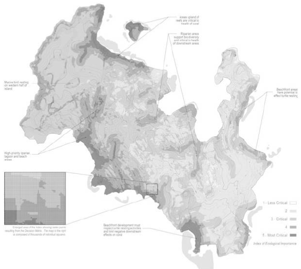
Figure 2: Index of Ecological Importance on Pearl Island. Darker areas are most critical.


S U G G E S T E D   A S S I G N M E N T

In order for students to learn about the concept Indices of Ecological Importance an assignment such as the following could be completed.

Part One: Reading

Students would be asked to complete a reading on Indices of Ecological Importance. Pages 300-302 of S. Bry Sarte’s Sustainable Infrastructure : The Guide to Green Engineering and Design would be appropriate.

Part Two: Questions

Students would be asked to complete the following questions:

  1. In your own words, summarize the concept of Indices of Ecological Importance in a few sentences.
  2. What are some of the benefits of this approach?
  3. For which types of projects would this approach be most appropriate?
  4. Are there projects where this approach would not be appropriate? Explain.
  5. Name at least two ways in which this design approach could be improved.

Part Three: Create an Index of Ecological Importance

Students would be given a sample area and development project for which to create an Index of Ecological Importance. A map of the area would be provided. Students would be expected to come up with a list of at least ecological conditions or data sets, and then create a decision matrix to weigh the relative values of these criteria. Finally, students would be asked to create a rough map of the ecological importance of the site based on their decision matrix and the map provided.


R E F E R E N C E S

Sarte, S. B., Mr. (2010). Sustainable Infrastructure: The Guide to Green Engineering and Design. Hoboken, NJ: John Wiley & Sons.


Closer Look Into Green Streets


Green Streets

The traditional design of streets is created of an impervious surface can make large amount of runoff when it rains. As the water runs along the surface it can pick up pollutants that then enter the water system. The water system can either be two separate systems: one for stormwater and the other for sanitary water or it can be a combination of the two. Either way some of these systems can’t handle the large peaks of runoff which a rain storm can produce. These volumes cause overflowing of basins and catchments which can leads to high volumes being released into the environment which can be very harmful. One of the ways to manage these high volumes and contaminant release is implementing green streets. Green Streets are a good example of how sustainable site planning can be implemented to create many benefits to a system that is already in place but can at some times be harmful to the environment. There are many sustainable benefits to Green Street which can be seen in the following list:

  • Improving water quality, air quality, temperature, aesthetics and safety
  • Reduce the peak flows that impact the underground storm water infrastructure
    • Smaller and fewer pipes and less maintenance
  • Help prevent flooding
  • Improving, restoring and protecting water as a resource
  • Promote alternative surfaces
  • Promote renewable energy for street lights
  • Reducing heat that radiates from the hard surfaces
  • Promotes more appealing pedestrian use by being more walk-able, safe and attractive
  • Sense of place, higher livability

The following are some examples of what the infrastructure that might be included in a Green Street:

  1. Porous pavement

Porous pavement could be made of pervious concrete, porous asphalt or permeable interlocking pavers. Implementing porous pavement infiltrate, treat and store runoff. It can be cost effective where land values are high and flooding and icing is a problem.

picture-1

(http://njwsawpu.blogspot.ca/2011/06/permeable-pavement-epa.html)


  1. Vegetated Curbs and sidewalks

Adding more vegetation will result in more of the rainwater being absorbed into the soil rather than being put in the stormwater system. Absorbing the water filters contaminants out of the water stops the contaminants from being released into the environment as well as reduce the peak flow volumes.

2

(http://www.deeproot.com/blog/blog-entries/the-rise-of-the-curb-cut-part-two)


  1. Planter Boxes

Planter boxes are garden with vertical walls and either have open or closed bottoms. These can collect and absorb runoff from sidewalks, parking lots and streets. They are ideal for space-limited sites in dense areas.

3

(http://www.lastormwater.org/blog/2015/01/university-park-rain-gardens-to-grow/)


  1. Rain garden: Biowales

Biowales are vegetated, mulched or xeriscaped channels that provide treatment and retention as they move stormwater from one place to another. The vegetated swales slow, infiltrate and filter the flow of stormwater. This system is well suited along the sides of streets and parking lots.4

(http://www.bizjournals.com/portland/blog/sbo/2014/01/world-cities-looking-to-portland-for.html)


  1. LED Lights

Implementing LED lights into the street lights will reduce the energy used to light the streets while also, providing a brighter environment at night. This can be an example of how implementing green streets can promote the use of renewable energy.


An Example of Implementations:

Philadelphia has multiple projects that were implement all over the city. One of them is the Queen Lane Water Treatment Project. They implemented vegetated curb extension that protrude into the street creating a new curb. This curb is made of a layer stone topped with soil and plants. The curb design allows the runoff to flowing into the vegetation area so the plants can store and filter the runoff. Excess runoff can flow into the existing inlet which leads to the treatment plant. As well there is a downspout planter which allows the runoff from roof gutters to flow through the plants, which has the similar benefits as the curb design discussed above.

5

(http://www.phillywatersheds.org/what_were_doing/green_infrastructure/projects/QueenLane)

For more examples of other green street implementation in Philadelphia refer to their Green Streets Programs (http://www.phillywatersheds.org/what_were_doing/green_infrastructure/programs/green_streets).


Resources:

https://www.youtube.com/watch?v=TxqxEqnHIKw&app=desktop

https://www.epa.gov/green-infrastructure/what-green-infrastructure

http://www.phillywatersheds.org/what_were_doing/green_infrastructure/projects/QueenLane


Constructed Wetlands I

One of the alternative solutions to wastewater treatments that are widely used nowadays are the constructed wetlands. These wetlands are shallow pools developed specifically for storm or waste water treatment that create growing conditions suitable for wetland plants. They are great alternatives to remove contaminants from wastewater, and have been used for decades now.
Constructed wetlands have the same properties as natural wetlands, and are designed to provide water quality benefits through various process that will ultimately minimize pollution prior to the water entry to streams. They also act as biofilters, and remove sediments and pollutants such as heavy metals from the water, and can even serve as wildlife habitat even though that is outside the scope of its main purposes.

There are 2 types of constructed wetlands:

Surface Flow Systems (Free water surface):

A surface flow constructed wetland have standing water at the surface, and can be used as a tertiary treatment facility at a wastewater treatment plant. This system consist of a basin full of water, and macrophytes roots planted that emerge at the water surface. The effluent water is treated as it flows over the soil, and organic material is removed through microbial degradation.

The figure below shows a surface flow constructed wetland.

2016-11-02-12

Subsurface Flow Systems:

Subsurface systems have no visible standing water, and are designed so that the wastewater flows through a gravel substrate beneath the surface vegetation.The wastewater passes through a sand medium on which plants are rooted. A gravel medium (generally limestone or volcanic rock ) can be used as well and is mainly deployed in horizontal flow systems though it does not work as efficiently as sand.
In the vertical flow constructed wetland, the effluent moves vertically from the planted layer down through the substrate and out. In the horizontal flow CW the effluent moves horizontally, parallel to the surface.

The figure below shows a subsurface flow constructed wetland.

2016-11-02-14

Constructed wetlands are then extremely important to wastewater and play a big role in gray water systems. Just like other major systems, they include all components necessary to the efficient treatment of gray water such as: collection of water, treatment, disinfection, and distribution.

References:

http://www.ces.uoguelph.ca/water/NCR/ConstructedWetlands.pdf

https://www.epa.gov/wetlands/constructed-wetlands

http://www.gov.pe.ca/photos/original/eef_wildlife_p1.pdf

Constructed Wetlands II

This weeks learning, titled “Design for Water conservation and Waste-Water management” explored how the ecosystem approach to urban infrastructure design required engineers to consider the whole water cycle. That allows us as engineers to  build infrastructure that restores the natural balance of water in ecosystems.  While much of the reading was highly applicable and interesting, I was particularly intrigued by the idea of constructed wetlands and decided to investigate this topic further.

4130876_orig
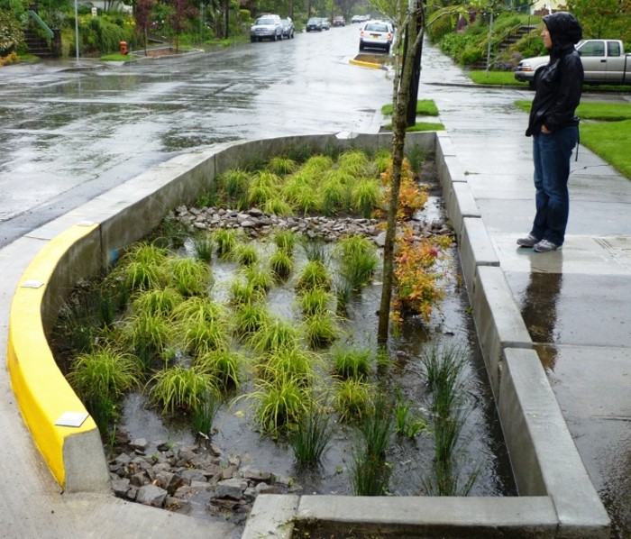
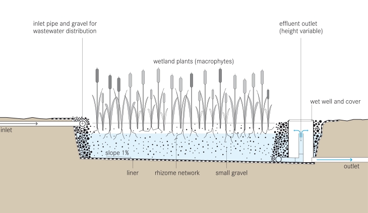
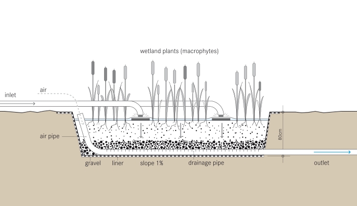
Above – A beautiful constructed wetland in action at the Lincoln Park Zoo in the USA.                             Source:http://www.acornponds.com/bog-filtration.html
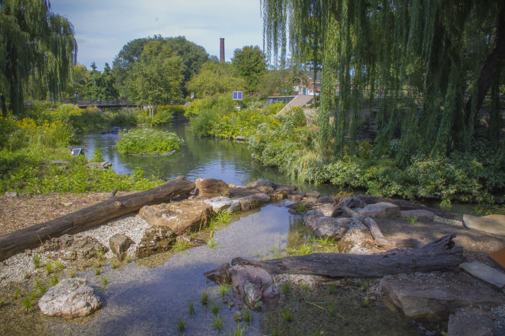
What is a Constructed Wetland?

Constructed wetlands are engineered systems that use natural functions of vegetation, soil, and organisms to treat different water streams. Depending on the type of wastewater that has to be treated the system has to be adjusted accordingly which means that pre- or post-treatments might be necessary.

Constructed wetlands can be designed to emulate the features of natural wetlands, such as acting as biological-filters or removing sediments and pollutants such as heavy metals from the water. Constructed wetlands sometimes serve as a habitat for native and migratory wildlife, although that is usually not their main purpose.

There are three main types of Constructed Wetland:

  • Subsurface flow constructed wetland – this wetland can be either with vertical flow (the effluent moves vertically, from the planted layer down through the substrate and out) or with horizontal flow (the effluent moves horizontally, parallel to the surface)
  • Surface flow constructed wetland
  • Floating treatment wetland


Cost of Constructed Wetlands

Constructed wetlands are self-sustaining, and thus their lifetime costs are significantly lower than those of conventional treatment systems. Often their capital costs are also lower compared to conventional treatment systems. They do take up significant space, and are therefore not preferred where real estate costs are high. Overall, constructed wetlands are generally significantly cheaper than conventional treatment systems.

How do they Work?

A constructed wetland is an engineered sequence of water bodies designed to filter and treat waterborne pollutants found in sewage, industrial effluent or storm water runoff. Constructed wetlands are used for wastewater treatment or for greywater treatment, and can be incorporated into an ecological sanitation approach. They can be used after a septic tank for primary treatment, in order to separate the solids from the liquid effluent. Some CW designs however do not use upfront primary treatment.

Vegetation in a wetland provides a substrate (roots, stems, and leaves) upon which microorganisms can grow as they break down organic materials. This community of microorganisms is known as the periphyton. The periphyton and natural chemical processes are responsible for approximately 90 percent of pollutant removal and waste breakdown. The plants remove about seven to ten percent of pollutants, and act as a carbon source for the microbes when they decay. Different species of aquatic plants have different rates of heavy metal uptake, a consideration for plant selection in a constructed wetland used for water treatment. Constructed wetlands are of two basic types: subsurface flow and surface flow wetlands.

tilley_et_al_2014_schematic_of_the_vertical_flow_constructed_wetland

Above is an example Horizontal Subsurface Flow Constructed Wetland. Source: https://en.wikipedia.org/wiki/File:Tilley_et_al_2014_Schematic_of_the_Horizontal_Subsurface_Flow_Constructed_Wetland.jpg

tilley_et_al_2014_schematic_of_the_vertical_flow_constructed_wetland-1

Above is an example of a Verticale Subsurface Flow Constructed Wetland. Source: https://en.wikipedia.org/wiki/Constructed_wetland#/media/File:Tilley_et_al_2014_Schematic_of_the_Vertical_Flow_Constructed_Wetland.jpg

How well does this connect to this weeks reading?

The concept of Constructed Wetlands connects very well to our reading. The following are some key connections:

  • An excellent use of innovative technologies.
  • Provides a long term water management plan.
  • Address both wastewater and stormwater concerns.
  • A great example of the ecosystem approach – not only are constructed wetlands providing an ecosystem service to the human population (waste control), but they also create additional oxygen producing plants and provide a habitat for local birds and wildlife.

References:

Canada Mortgage and Hoursing Corporation – “Constructed Wetlands”                                           https://www.cmhc-schl.gc.ca/en/inpr/su/waho/waho_008.cfm

USA Environmental Protection Agency – “Constructed Wetlands”                                                     https://www.epa.gov/wetlands/constructed-wetland

Water Canada – “Constructed Wetlands: How Cold Can You Go?”                                                     http://watercanada.net/2009/constructed-wetlands/

School of Environment Sciences, University of Guelph – “Constructed Wetlands” http://www.ces.uoguelph.ca/water/NCR/ConstructedWetlands.pdf

Spam prevention powered by Akismet