The following environmental impact assessment for Northland Properties and Aquilini Investment group of Vancouver, focuses on the proposed project of a year round destination mountain resort on Brohm bridge. With a total project area of 54,717,275 m2, located on Highway 99, 80 kilometres north of Vancouver and 45 kilometres south of Whistler, the ski resort project commonly referred to as the Garibaldi to Squamish Project would consist of 124 ski trails, 21 lifts and will involve accommodation as well as commercial developments.
Produced for the project proponents, and constructed in response to the critics advanced by Whistler in a 14 page letter, and by the BC Environmental Assessment Office, this document, its analysis and accompanying map of the project, aim to work towards developing a strong argument supporting the development of the project, evaluating criticisms, and make recommendations regarding what are the priorities in order to proceed with the proposal and what are the main issues to be addressed and their possible solutions, as well as the more minor details which even if less critical still need to be taken into consideration.
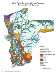
Data was gathered from DataBC, a central spatial warehouse for data, applications and geographic services in British Columbia, and from the BC Government, which was provided by the department of Geography at the University of British Columbia. In order to analyse the data, the different layers: Ungulate Winter Range, Old Growth Management Areas, Ecosystem mapping, Elevation model, Parks and protected areas boundary, roads, rivers, and 20 m contours, were all added together in the geographic information system software ArcMap. The different layers were made to all be in the same projection. The data was parsed: structured and categorised for organisation, and filtered; for instance all of the layers were clipped (cropped) to fit only the project boundary in order to isolate information and target our analysis to the desired area of the ski hill project in order to determined the feasibility of building a ski resort in that area.
Determining the feasibility of building the ski resort — Questions of interest:
- Will there be enough snow in the area?
- Percentage of total project area lower than 600m vertical = 8%
- More than two thirds of the project area is above 600m, which makes the ski resort an appropriate place for skiing, knowing that most of the slopes will certainly located at higher elevation
- Is the resort easily accessible by roads?
- As observed on map, roads provide access to higher levels up in the mountain
- How much percentage of the project area falls into protected areas?
- Sum of individual protected Areas, percentage of total project area = 65,74%
- Protected Areas, percentage of total project area (corrected for overlapping) =68%
- Old growth management area (old growth forest), percentage of total project area = 78%
- Ungulate Winter range areas (Mule Deer and Mountain goat), percentage of total area =88%
- Endangered Ecosystem (Red-Listed Ecosystem Area), percentage of total area = 83%
- Percentage of Falsebox in project area= 0.54%
- Percentage of Salal in project area=5.38%
- Percentage of Cladina in project area= 1.49%
- Percentage of Kinnikinnick in project area= 0.33%
- Percentage of Flat Moss in project area= 15.99%
- Percentage of Cat’s-tail moss in project area= 1.10%
- Fish bearing (Riparian zones), percentage of total area =28%
What are the two greatest environmental concerns to project development and are there ways to mitigate them?
By looking at the results of the environmental assessment analysis and at its resulting map (MAP 1 – overleaf), it is possible to figure that one of the main environmental concerns of the project’s development is the percentage of endangered red-listed ecosystem area, which is 24.83%. However, it is important to note that when looking at the map it is possible to observe that in fact, most of the red-listed ecosystem areas are below 600 m. The second major environment concern is the percentage of Riparian zones (fish bearings) in the area, which is 26.28%.
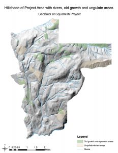
One way to mitigate these environmental concerns, and thus to promote the development of the project would be to avoid those areas when developing accommodation and commercial planning; by, for instance, concentrating constructions and the ski resort to areas above 600 meters; a potential area representing more than 68% of the total project area in Garibaldi, Squamish and which already has roads for access. As a result, this would not only prevent harm to red-listed species, which are mostly concentrated below 600m (Map 1) but it would nullify Whistler’s criticism that the Skill Hill Project is located too low in elevation. Furthermore, if the proponents make sure that the project includes environmentally harmless sewage and evacuation systems for waste and toxic materials, then the riparian zones should not be affected negatively. Indeed, other than the potential effects of pollution, skiing activities are usually not concentrated near streams. The priority in order to proceed to the proposal is to select more precisely the specific areas where the project will be built in order to avoid areas below 600m, avoid wildlife habitat, and red-listed species areas, and thus to show to the BC Environmental Office that the project area will have a limited impact on vegetation, fish and wildlife habitat. In addition, when analysing the hillshade of the project area (Map 2 – overleaf) it is further possible to show that large areas of the mountain above 600m does not include Old growth forest areas nor Ungulate Winter Range (Wildlife) and that the project area thus holds serious potential in developing a ski resort project.