Identifying Tsunami Risk in Vancouver, BC
Summary
15.49% of the City of Vancouver’s total area would be affected by the potential threat of a tsunami. – Method used: used the attribute table to find the total area of Vancouver. For the potential affected area, obtain the
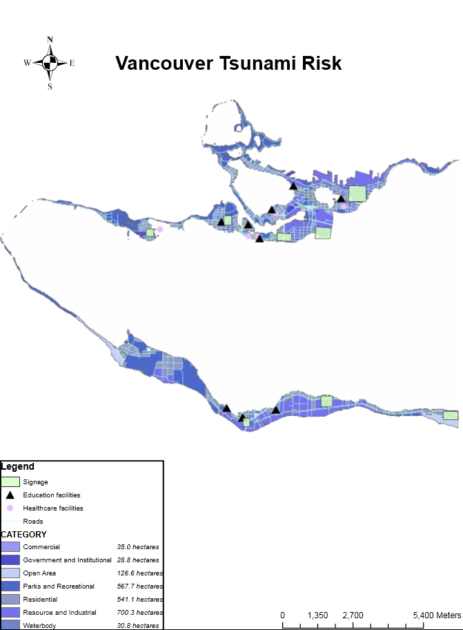
sum from the attribute table and divide by the total area of Vancouver.
For Vancouver’s health facilities, the following are in danger:
- FALSE CREEK RESIDENCE
- BROADWAY PENTECOSTAL LODGE
- COAST WEST COMMUNITY HOME
- YALETOWN HOUSE SOCIETY
- VILLA CATHAY CARE HOME
For Vancouver’s educational facilities, the following are in danger:
- ST ANTHONY OF PADUA
- ECOLE ROSE DES VENTS
- HERITAGE 3R’S SCHOOL
- VANCOUVER MONTESSORI SCHOOL
- FALSE CREEK ELEMENTARY
- EMILY CARR INSTITUTE OF ART & DESIGN (ECIAD)
- HENRY HUDSON ELEMENTARY
- ST JOHN’S INTERNATIONAL
- ST FRANCIS XAVIER
- INSTITUTE OF INDIGENOUS GOVERNMENT (IIG)
Method
Used the clip tool to create a layer containing only educational facilities that would be in the danger zone. The equivalent was done for health facilities. names were then obtained through the attribute table.
Accomplishments
Gained an understanding of how to use extraction tools such as the clip tool and the overlay tool, which allowed for the extraction of data necessary when determining low-elevation areas at risk.