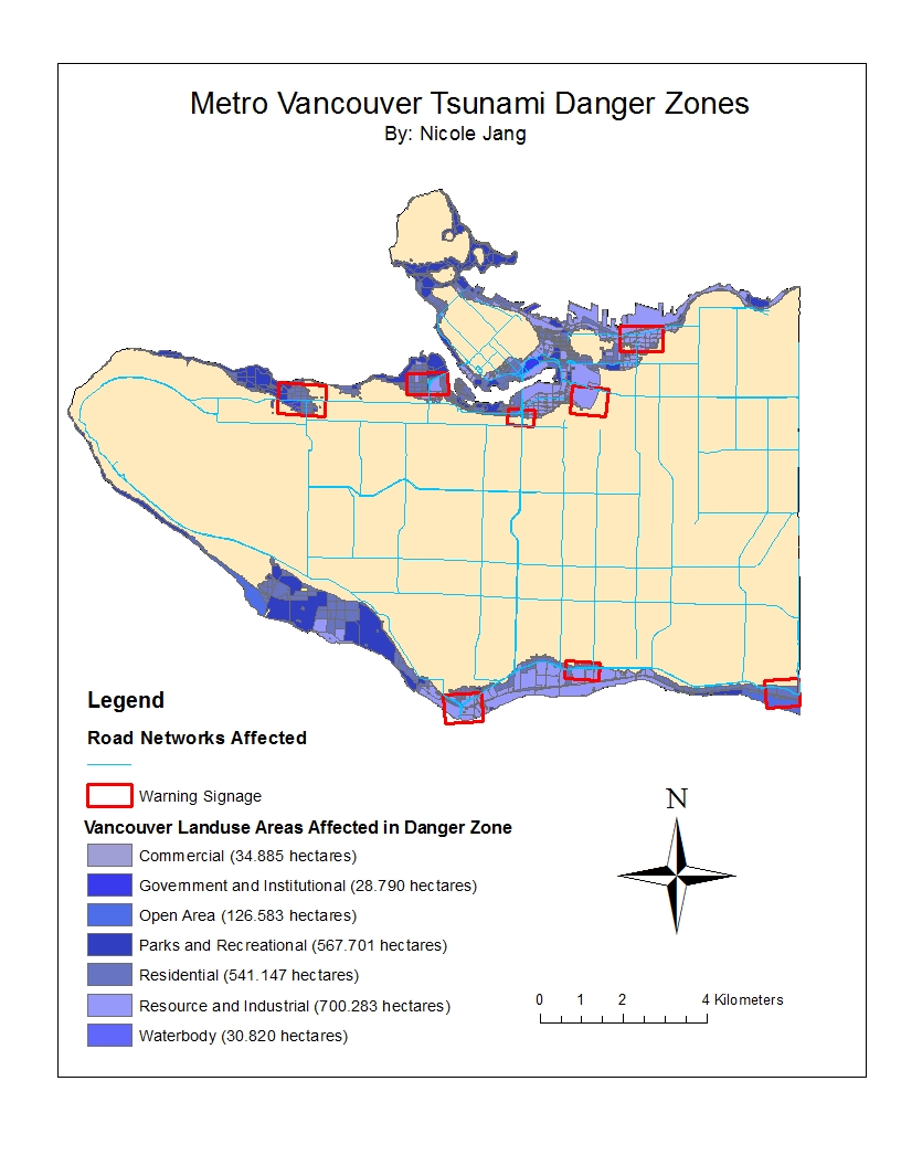
In the event of a tsunami, the percentage of the City of Vancouver’s total area that is in danger is approximately 15.5%. To find this value I found the total area of all areas in danger in the City of Vancouver, 20314805.889169 sqaure meters which was found under the Vancouver_Danger layer, and I divided it by the total area of the City of Vancouver, 131033339.950334 square meters which was found under the Vancouvermask layer. I multiplied the value by 100 to get the percentage.
| Healthcare Facilities in Danger | Educational Facilities in Danger |
| False Creek Residence | St. Anthony of Padua |
| Broadway Pentecostal Lodge | Ecole Rose Des Vents |
| Coast West Community Home | Heritage 3R’s School |
| Yaletown House Society | Vancouver Montessori School |
| Villa Cathay Care Home | False Creek Elementary |
| Emily Carr Institute of Art & Design (ECIAD) | |
| Henry Hudson Elementary | |
| St. John’s International | |
| St. Francis Xavier | |
| Institute of Indigenous Government (IIG) |
I found these danger zones by clipping the Vancouver_Danger layer with the Vancouver_healthcare layer and opening the attribute table to see which health care facilities were in the danger zone. I then did the same thing with the Vancouver_Danger layer and the Vancouver_education layer.
ACCOMPLISHMENT STATEMENTS:
- Acquired basic knowledge of the ArcGIS software by understanding it’s functions in order to analyze maps made by the software and perform geographical analysis.
- Utilized knowledge of misaligned and improperly referenced spatial data to distinguish distortions and specific biases that are visible on maps.
- Used spatial analysis, tabular datasets and ArcGIS applications to create a map highlighting the zones of the city of Vancouver that are in danger if a tsunami is to occur.