Results
Multi-Criteria Evaluation:
In the MCE analyses, very few areas were identified to be ideal or potential sky viewing areas in the City of Vancouver. As observed in both the crime density and street light density map and the land use map, majority of areas in the City of Vancouver were deemed poor for sky viewing instead. The areas of each sky viewing category were determined. The results are as follows:
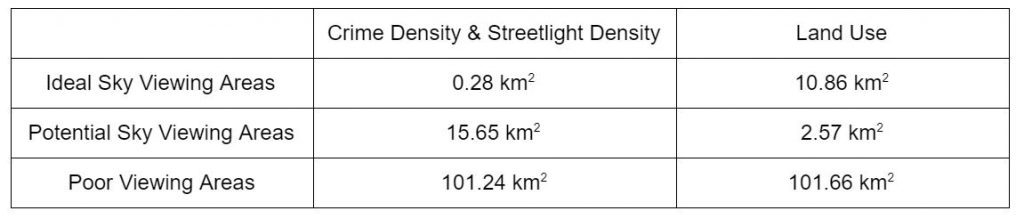
Table 1. The total areas of Vancouver that were classified as “Ideal Sky Viewing Areas”, “Potential Sky Viewing Areas” and “Poor Sky Viewing Areas”. This was determined for both the crime density and street light density MCE as well as the land use MCE.
Through observation of the maps and through comparing values in Table 1, similar values of “Poor Viewing Areas” were found in both MCEs. It is apparent that the land use MCE identified more areas of Vancouver as ideal or potential sky viewing areas compared to the crime density and street light density MCE.
Overlaying the parks layer with the results of the MCE analyses, the following parks were identified as ideal or potential sky viewing areas in the City of Vancouver:
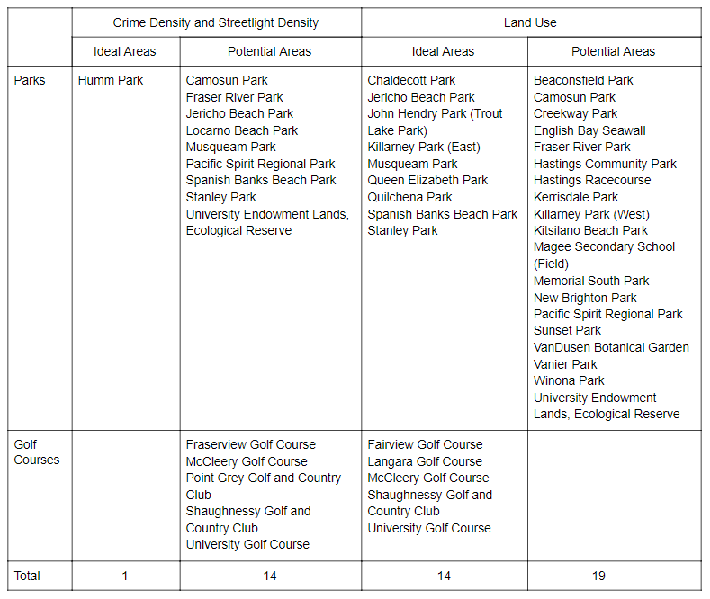
Table 2. Parks that have been identified as ideal or potentially ideal sky viewing areas from the crime density and street light density MCE and land use density MCE. Please note that the City of Vancouver has included golf courses into the parks inventory for the city.
As a result, the MCE conducted using crime density and streetlight density as a measure for safety has identified Humm Park as the only ideal site for sky viewing. Interestingly, the MCE which used land use hierarchy by crime as a measure for safety has identified 9 parks and 5 golf courses in the City of Vancouver as ideal parks which include areas such as Queen Elizabeth Park, Spanish Banks Beach Park, and Stanley Park.
In the process of overlapping a weighted MCE with its corresponding equally weighted MCE, the sensitivity analysis highlighted Pacific Spirit Regional Park, Fraser River Park, Camosun Park and University Endowment Lands Ecological Reserve as potential sky viewing areas in both the crime density and street light density MCE as well as the land use MCE. These parks can be clearly seen in the maps linked below (i.e., areas shaded in grey). Strikingly, ideal sky viewing areas do not overlap between the two maps.
While parks with large areas in Vancouver tended to have some portions that were identified as being ideal in the land use map, very few of the parks with larger areas were identified as being ideal in the crime density and street light density map. In addition, areas closer to the coast line of the city were found to have ideal sky viewing areas – this is most prominent in the land use map. For example, Stanley Park and Spanish Banks Beach Park, located in northern part of the city near the Burrard Inlet, were identified as being ideal areas for sky viewing in the land use map. As well, there are fewer residents living along the coast in these areas. This is in contrast to parks found in the center of the city, where very few were identified as being ideal sites for sky viewing.
The following maps were created as a result of the MCE analyses:
- Map 1: Multi-Criteria Analysis using Crime Density and Streetlight Density
- Map 2: Multi-Criteria Evaluation Using Land Use
Least-Cost Pathway:
Least-cost pathways were created using parks identified from the two MCEs. These were calculated using Downtown Vancouver as the source, more specifically the intersection of Burrard St. and Robson St. (i.e., a popular tourist area), and 3 parks that met the following criteria:
- Percentage of the park’s area that overlapped with ideal sky viewing areas;
- Ease of travelling to the park and accessible;
- Space to settle down and gaze at the stars (Are there any parts of the environment that will hinder the ability to see the sky? Things that can hinder the ability to see the sky include tree canopies);
- Safety (Are we far enough away from the city, but also from hazards, such as cliffs, large bodies of water, etc.?).
Taking these factors into account, the following parks were used to conduct least-cost path analyses:
- Crimes and Street Lighting as a measure for safety: Humm Park
- Land Use Hierarchy by Crime as a measure for safety: Queen Elizabeth Park and Spanish Banks Beach Park
Distance from the Robson St. and Burrard St. intersection to each park was determined by finding the shortest distance and length of the least-cost path. The results are as follows:
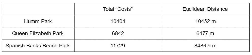
Table 3. The results of the least-cost path and shortest distance (i.e., Euclidean distance) analyses.
It was found that Queen Elizabeth Park had the smallest least-cost path values, suggesting that it is the most convenient park to travel to from the source. In addition, Queen Elizabeth Park was also found to have the shortest distance from the source.
The following map shows the least-cost path to the 3 ideal sky viewing parks (identified from each MCE) from a popular tourist area in Downtown Vancouver.