Introduction
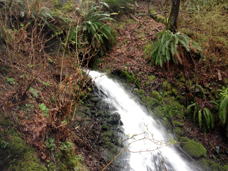
At the beginning of the semester, we were requested to help the UBC SEEDS and the Botanical Gardens slow down Rock Creek in order to reduce erosion in the stream bed and off the cliff across Old Marine Drive, make stream more full during low rain periods, reduce the risk of flooding at peak rain periods, and store water for emergency use or irrigation. The following post explores the progress, successes, and challenges we’ve had while striving to meet these objectives as well as the outcomes that have resulted from our time and effort.
Implementation Progress
In the past two weeks, we have focused on gathering detailed data about the site, such as flow rate data, stream dimensions, elevations and soil type. These sets of information will help us decide on the exact methods and locations to implement our ideas that most efficiently create a slower flow velocity in the stream.
In gather the stream flow rates, Patti, who also worked on this project in her fourth year of civil engineering, provided us access to the data collected from a probe throughout the year. When compared with the data from a similar probe in Dr. Atwater’s office, the water pressure in the stream at a given time can be found and used to calculate the volumetric flow rate through Rock Creek.
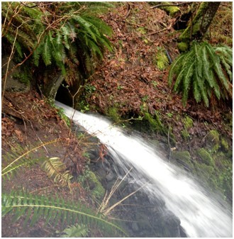
After the flow data had been collected, our team visited the stream to assess the dimensions of the stream in detail. The stream width and water depth was measured at various locations and will be used to calculate, along with the volumetric flow rate of that day, to calculated stream velocity at those locations. This, along with elevation data we gathered from VanMaps, provides us with an accurate dimensional picture of the stream. The height of the stream bank was also measured and important stream features, such as the abrupt changes in flow speed and elevation, were noted along the stream. We also noted that the banks and bed of the stream mostly consisted of stone and fine soils, such as silts or clays. This indicates that seepage around the stream is not a major point of concern, and storage of water along the stream is possible.
All the data we have collected will be compiled and used to determine which designs are more beneficial towards a specific location along the stream. We will consider the maximum allowed water level, should we decide to propose a dam or weir to store water; we will look into roughening locations in the stream that have shallower banks; we will optimize our recommendations to maximize the amount of water we can keep in the system throughout the year and minimize stream erosion during rainy seasons.
Gone Well
Our objectives in the Botanical Garden project are being achieved successfully all thanks our access to large amounts of data. Internet websites such as Vanmap has provided us with accurate elevations along the stream, while Google maps provide us with a clear aerial view of the project site. UBC’s personnel have also been very supportive of our project. Doug, the garden manager, expressed his goodwill by touring the CBEL group through the garden on multiple occasions. Patti, on the other hand, allowed us access to the sensor data, which contained volumetric flow rates of the stream throughout the year. Lastly, the CBEL group personally conducted field measurements that included the cross sectional area of the stream, as well as coordinates and elevations along the stream.
With complete data obtained from sensors, field measurements, and the internet, the CBEL team succeeded in creating a detailed model of the stream and understanding its behaviors. We were able to identify limits in our knowledge of the system. Deficits in knowledge include erosion on the cliff, our scope for the garden, and our technical knowledge about open channel flow. Due to the completeness of the data, group members are free to apply knowledge learnt from the classroom in the planning of an effective strategy that tackles the client’s issues. After analyzing results from data and field surveys, we have identified the main cause of the cliff erosion to be the fast movement of water near the pipe opening.

Needed Extra Work
At the same time, there are still some aspects needed extra work. First of all, it was hard to get the ball rolling because our clients had different requirements and discrepancies of the project. Dr. James Atwater pointed out that the most important issue of the project was to reduce the erosion of the culvert and cliff; while Mr. Douglas Justice wanted our final solutions help more about water storage and potential stream flooding. Currently, our optimum solution focuses on slowing down the stream water in general, storing water for low rain periods, and preventing potential flood. We believe that there is nothing we can do to reduce erosion down the cliff, but we may come up with some additional suggestions to that erosion later in our report. In addition, we still need more survey to complete our data base of the geological condition and stream water. We have done the survey once, but based on our skills and tools, we did not get very accurate results. Therefore, Chris is planning to do one more survey and get some additional data. Finally, more information about electric machines, such as pumps, is also needed so that we can provide some other additional solutions, which may need higher costs, to our clients.
Project Outcomes
After collecting and measuring all the necessary data, our team was able to brainstorm a solution that will meet as many of the objectives as we can. First, we needed to rule out the potential solutions we believed wouldn’t have been the best for solving our problems:
- We ruled out diverting the stream – due to plants and trees that cannot be moved, we can’t divert the stream too far from Rock Creek. Therefore, a diverted stream would flow to the same culvert as Rock Creek and would not solve the erosion through the creek.
- One solution we thought might help would be widening the culvert at the bottom to prevent it from filling up to full capacity, which causes massive pressure build up – however, this is not feasible since the inconvenience of replacing the culvert tremendously outweigh the benefits it would bring.
- Implementing ponds, weirs, or streambed roughening individually would not be sufficient in achieving our goals, which is why our optimum design involves all three.
Eliminating all the lacking ideas helped us determine the ideal solution:
At the top, we suggest widening the stream into a pond – this allows for maximum water storage
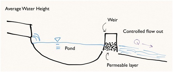
Immediately after the pond, we recommend adding a weir that is impervious on the surface, but permeable near the streambed. This will accomplish a controlled flow rate out of the pond, which reduces erosion, slows down the stream, and reduce the risk of flooding near the bottom of the stream.
1. During average pond depth, the water will flow into the pond and out the bottom of the weir as usual:
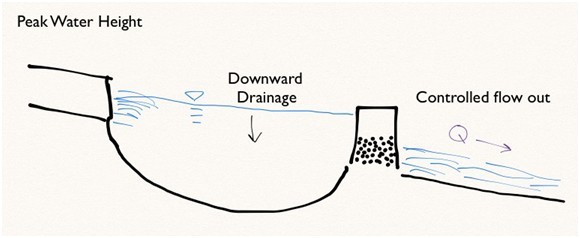
 2. During peak pond depth, the weir will allow the water in the pond to flow out at a controlled rate due to the downward drainage in the pond:
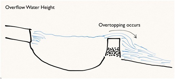
3. If the pond were to reach a height that over-tops the weir, the flow rate would no longer be controlled. However, we will make an educated prediction of pond volume and weir height to ensure this happens only in rare situations:
- We also recommend implementing many weirs throughout the length of the pond. We will do extensive research to determine the ideal locations of the weirs.
- Near the bottom of the stream, we plan on reducing the energy of the flow with friction by roughening the streamed with rocks and plants
- Around the culvert, we advise reinforcing the areas surrounding it to prevent bank erosion. As well, we realized that the flooding in the culvert may be due to obstructions caught inside, so we advise implementing a trap to catch obstructions and prevent plugging the culvert.
- We realized that our solution would only slightly help with the cliff erosion since the main cause of erosion is the steep gradient of the culvert underneath Old Marine Drive. This is a problem we do not have the power to fix.
 This is the framework of our solution that is explained in extensive detail in our report, which we will hand in to UBC SEEDS hopefully by next week.