
According to the 2022 Global Natural Disaster Assessment Report, floods were the most frequent natural disasters, up by 14% compared to their historical average, contributing to 8,049 deaths and over USD 44 billion in economic losses. There were 163 major floods worldwide, affecting over 57 million people and 80 countries, with India being especially impacted during the monsoon period1. With this information in mind, it is essential that we as environmental designers are conscious of the factors that contribute to flooding and the ways which we can assist in flood mitigation.
[1] “2022 Global Natural Disaster Assessment Report | PreventionWeb.”
What factors contribute to flooding?
Flooding occurs when water inundates an area of land that is typically dry. Floods can occur by various means: they may be the direct result of heavy precipitation, they may occur by the failing of infrastructure such as dams and levees, they can arise by the melting of snowfall or the breakup of ice dams on a river, they can be the result of the aftermath of earthquakes, or they may be caused by other atmospheric events such as tsunamis or storm surges that inundate coastal areas1.
Additionally, with the increase in wildfire occurrences comes a risk of erosion and flooding, which are common after extreme fires. Flooding occurs after wildfires due to the alterations in soil conditions, which include the formation of a water-repellant layer and higher erodibility. It is most likely to happen during summer or fall storms during the year of a fire or following a drought in subsequent years. This is due to dry soils, as they have the greatest water repellency, and a loss of forest and vegetative cover following the fire2.
While the most common causes of flooding are due to meteorological factors such as heavy precipitation and snowmelt, human activities also have a significant impact on the production and intensity of floods3.
Human activities:
Urbanization affects all aspects of the hydrological cycle. It contributes to compacted and impermeable surfaces, producing low infiltration rates, thus increasing runoff. When this occurs in cities, the stormwater sewers can exceed their capacity, resulting in flooding which is particularly problematic in combined stormwater-sewage systems. Urbanization and agricultural development also often involve the removal of natural vegetation which reduces the water absorption of the soil, inevitably increasing both the quantity and velocity of runoff. This can also contribute to soil erosion due to the loss of roots that anchor the soil in place. Additionally, the draining of wetlands for urban developments has aggravated the effects of floods due to their inherent flood-reducing characteristics4.
[1] Doswell, “HYDROLOGY, FLOODS AND DROUGHTS | Flooding.”
[2] Curran et al., “Large-Scale Erosion and Flooding after Wildfires.”
[3] Jones, “Human Modification of Flood-Producing Processes.”
[4] Jones.
What are the various types of flooding?
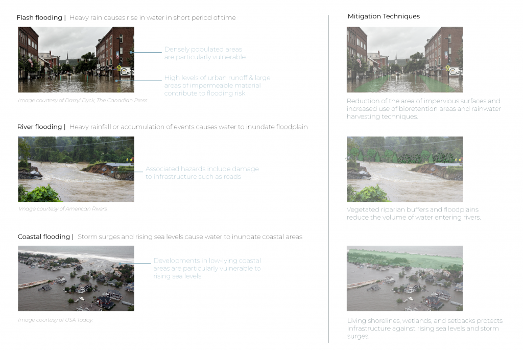
Flash floods are produced when heavy rainfall causes a rise in water in a short time period, typically occurring within small catchment areas. Areas of steep and rocky terrain, and densely populated areas, are particularly susceptible to flash floods as there are high levels of water runoff and limited absorption to counteract this. They are especially dangerous as these events happen very rapidly, leaving little time to prepare for evacuation, despite the forecasting of precipitation1.
River floods occur much more gradually, as individual rainfall events may accumulate, sending runoff into the main river from its surroundings or from a network of tributaries. The water level within the river will gradually rise, which may be compounded by other factors such as snowmelt, leading to flooding. Due to the longer timescale, there is more time to respond to the threat of rising water levels, thus reducing human injuries and fatalities. There are, however, associated factors with river floods, which include dam or levee failures, that can lead to conditions similar to those of a flash flood. Additionally, water may be intentionally released from dams or levees to prevent complete failure of these systems2.
Coastal areas are facing an increase in the frequency and intensity of storms, which are compounded by a rising sea level, resulting in coastal flooding. Storm surges from extreme storms have contributed to a great number of fatalities. Other impacts are beach erosion, disruption to ecosystems, salinization, and, similar to the other floods, damage to infrastructure3.
[1] Doswell, “HYDROLOGY, FLOODS AND DROUGHTS | Flooding.”
[2] Doswell.
[3] Warrick et al., “Climate Change, Severe Storms, and Sea Level.”
What conditions occur due to flooding?
Human health impacts (it is important to note that the human impact is much greater in developing countries):
- Fatalities- which is greatly related to the velocity of floodwaters, may occur due to drowning or being struck by debris carried by waters
- Infectious disease transmission,
- Mental health impacts1,
- Compromised drinking water because of water containing chemicals, microorganisms, and suspended silt
Damage to infrastructure and natural vegetation due to the energy of the moving water and the debris the water carries, which may include anything it sweeps away in its path or due to water immersion. Along floodplains, entire crops may be lost when inundated with water. Evidently, the resulting economic impact of this can be enormous.
Dirt and debris are left behind, which present health threats as well as high costs for cleanup and removal
They can relocate wild animals from their natural habitats to areas of proximity to humans.2
Positive results of floods:
- As flooding is a natural process, floodplains are highly fertile regions, rich in nutrients due to the deposition of nutrients by floods3.
- Rainwater restores and stabilizes the vegetative soil layer and purifies regions that may be prone to salinity.4
[1] Few et al., “Floods, Health and Climate Change: A Strategic Review.”
[2] Doswell, “HYDROLOGY, FLOODS AND DROUGHTS | Flooding.”
[3] Doswell.
[4] Watson and Adams, Design for Flooding : Architecture, Landscape, and Urban Design for Resilience to Climate Change.
What are the ways designers can mitigate flooding and/or the impacts of flooding?
Considerations of design that mitigates flooding ranges in scale from the building to the regional landscape and beyond with flood mitigation and floodplain management strategies. In “Design for Flooding : Architecture, Landscape, and Urban Design for Resilience to Climate Change”, a range of approaches to flood mitigation are presented. A few of these will be outlined below.
Small Scale
Impervious surfaces. As a general practice, it is best to reduce the area of impervious surfaces. During mild rainfall events, the runoff that occurs will be transferred by impervious surfaces, and because of this, the impervious surfaces should direct water towards vegetated areas. In these events, it is best for the rainfall to be managed in its immediate vicinity. Roof downspouts can direct water to vegetated areas provided the grading of the landscape is sloped to keep water away from the structure. It is important to note that lawns can be almost as impervious as hardscape, and they too should be sloped to direct water towards natural planted areas1.
Bioretention areas (Rain gardens). These are designed to absorb runoff from surrounding hardscapes, and thus should be located adjacent to impervious surfaces and lawns. Not only do they absorb runoff, but the plants act to filter the water and remove pollutants. They are best suited for milder rainfall events as heavy rainfall events would require an overflow, perhaps to a bioswale which stores water during lower precipitation and moves it at a slower velocity in periods of heavy inundation2.
Medium Scale
Rainwater harvesting. This process reuses water that falls on site through the storage during heavy rainfall and distribution when groundwater needs recharging3.
Native planting. As native plants are attuned to local conditions, they often require less watering and do not constitute the need for fertilizer use or frequent maintenance. In getting rid of landscapes that require fertilizers or other chemicals, the pollutants that are carried away due to flooding are reduced4.
Shoreline protection. Structural protection measures should be used minimally, and instead, when possible, be substituted for the restoration and revegetation of natural shorelines, the restoration of wetlands, adapting to sea level rise through setbacks, and reducing shoreline erosion through vegetative and geotextile means5.
Large scale
Riparian buffers. See page on riparian zones here.
Wetland restoration. See page on wetlands here.
Ecological wastewater treatment systems. This is a process of remediating wastewater through biological processes before it is reused or enters back into waterbodies. This may include a range of systems ranging from biofiltration tanks to wetland construction. This reduces the wastewater discharge into water bodies and streams, as would occur in combined sewer systems6.
Phytotechnology planting techniques. Plants may be used to clean up on-site pollutants or where future pollutants are expected to limit the harm of the pollutants on people and the environment.
Construction within floodplains. Due to the inherent flooding that occurs in these areas, construction should be limited or prohibited to protect both people and infrastructure7.
Relocation or elevation of infrastructure. When flooding is inevitable, infrastructure can be moved through managed retreat, or alternatively, elevated to prevent damage from water infiltration.
[1] Watson and Adams.
[2] Watson and Adams.
[3] Watson and Adams.
[4] Watson and Adams.
[5] Watson and Adams.
[6] Watson and Adams.
[7] Watson and Adams.
Additional resources
Design for Flooding : Architecture, Landscape, and Urban Design for Resilience to Climate Change by Donald Watson and Michele Adams
For further information on designing for flood mitigation or adaptation, this resource provides strategies for design, focused on flooding as an opportunity for design rather than solely viewing it as a risk or threat. It overviews the basic principles behind flooding and the meteorological contributions and discusses both local and regional implications of flooding and design, while promoting design through a watershed approach. A comprehensive list of architectural and landscape interventions are provided within this framework. Lastly, the book also provides an overview of national strategies for flood management and briefly introduces the successes of various countries in their approaches.
Sources
“2022 Global Natural Disaster Assessment Report | PreventionWeb.” https://www.preventionweb.net/publication/2022-global-natural-disaster-assessment-report.
Curran, Mike, Bill Chapman, Graeme Hope, and Dave Scott. “Large-Scale Erosion and Flooding after Wildfires.” B.C. Ministry of Forests and Range, 2006.
Doswell, C.A. “HYDROLOGY, FLOODS AND DROUGHTS | Flooding.” In Encyclopedia of Atmospheric Sciences, 201–8. Elsevier, 2015. https://doi.org/10.1016/B978-0-12-382225-3.00151-1.
Few, Roger, Michael Ahern, Franziska Matthies, and Sari Kovats. “Floods, Health and Climate Change: A Strategic Review.” Tyndall Centre for Climate Change Research, November 2004.
Jones, J.A.A. “Human Modification of Flood-Producing Processes.” In Floods, by D.J. Parker. Routledge, 2000.
Warrick, R.A., K.L. McInnes, A.B. Pittock, and P.S. Kench. “Climate Change, Severe Storms, and Sea Level.” In Floods, by D.J. Parker, n.d.
Watson, Donald, and Michele Adams. Design for Flooding : Architecture, Landscape, and Urban Design for Resilience to Climate Change. John Wiley & Sons, 2010. https://ebookcentral.proquest.com/lib/ubc/reader.action?docID=624403&ppg=20#.
Precedents
Taopu Central Park: James Corner Field Operations
Location: Shanghai, China
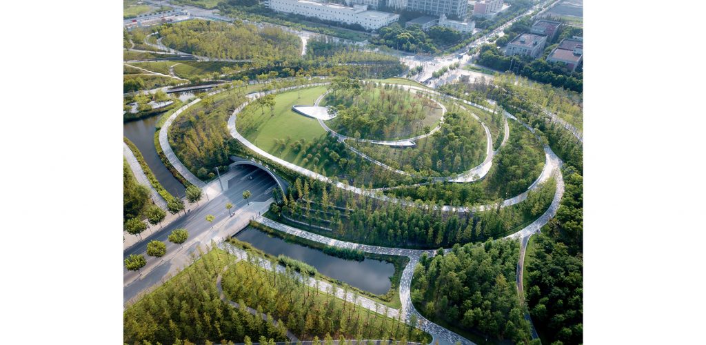
“Taopu Central Park is the unifying element and urban green lung for Taopu Smart City, a science and technology hub in northwest Shanghai. Inspired by traditional Chinese culture’s tenets of graceful movement and beauty, the park’s dynamic and fluid network of pathways, waterways, and topography improve water quality, manage stormwater, provide an elegant soil remediation strategy, and create connections that transform industrial lands into a living ecosystem and a new kind of urban ecological park for China.”
This project can be viewed here.
Climate Ready Dorchester: SCAPE
Location: Boston, USA
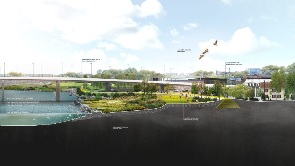
“The Dorchester shoreline stretches 9.5 miles along Boston Harbor and the Neponset River. Open space, marshland, and parks line the waterfront, but these spaces are not connected to each other or to adjacent inland communities. Today, only limited points of access remain, and these align with major inundation pathways. Climate Ready Dorchester expands the vision for the future of the Dorchester shoreline, offering strategies to adapt to coastal flood risk while also establishing a framework to connect the waterfront parks, beaches, and marshes in Dorchester, transforming them into one accessible, continuous waterfront – The Dorchester Shoreway.“
This project can be viewed on SCAPE’s website and on the City of Boston’s website.