
The riparian zone is a semi-terrestrial transitional area, or ecotone, starting at the edge of a water body and extending to the limit of the upland area, and thus plays a role in the interactions between terrestrial and aquatic zones.1 Riparian zones are heavily influenced by the movement of sediment through erosion and deposition, by hydrology (specifically the exchanges between groundwater and surface runoff), and by vegetation.2 The ecosystems themselves vary along the course of a river, giving rise to distinct vegetation zones and microhabitats.
[1] Décamps, Naiman, and McClain, “Riparian Zones.”
[2] “Riparian Landscapes – ScienceDirect.”
What is the role of the riparian zone?
Riparian zones foster high biodiversity of plants which in turn provide a myriad of contributing habitat functions such as pollen, shelter, and resting sites for migratory species, among many other functions. They also retain and filter nutrients from upland areas, serve as areas of organic matter recycling and carbon sequestration, provide sediment detention, thermal regulation, and bank stabilization.1 They also transfer plant litter to streams and rivers, which ultimately gets decomposed and subsequently used in the aquatic food web.2
There are multiple hydrological factors influencing the riparian zone: river flow, groundwater upwelling, rainfall, and surface runoff. The riparian vegetation is largely dependent on the availability of water, and therefore changes in the hydrology, especially of river flow, will directly impact the vegetation.3
[1] Merritt, “Riparian Zones.”
[2] “Riparian Landscapes – ScienceDirect.”
[3] “Riparian Landscapes – ScienceDirect.”
What are the anthropogenic impacts on riparian zones?
Flow regulations, the introduction of pollutants, change in climate, and altering land use are the primary anthropogenic influences impacting riparian zones. Flow regulation includes the construction of dams, the channelization or dredging of the water body which lowers the water table and thus alters the composition of species, and levees which separate rivers from floodplains.1
[1] Décamps, Naiman, and McClain, “Riparian Zones.”
How can environmental designers care for or restore riparian zones?
It is important that the connection between the riparian zone and in-stream habitat is maintained, and that this relationship be viewed at the watershed scale, as opposed to local scales. This approach allows for interactions along different habitat zones, along the continuum of rivers, and between atmospheric water and ground and surface water. As noted by Tomer, various water quality concerns within a watershed may be solved by appropriate riparian zone management as they are adjacent to waterbodies and greatly affect the sediments, pathogens, temperature, and algae present within these waterbodies1. Management of riparian zones includes maintaining vegetation over the soil, protecting the diversity of plants, removing invasive species, among other practices that can be found here2.
[1] Tomer, “Watershed Management.”
[2] Ministry of Agriculture and Food, “Management of Riparian Areas – Province of British Columbia.”
Sources
396–403. Elsevier, 2009. https://doi.org/10.1016/B978-012370626-3.00053-3.
Food, Ministry of Agriculture and. “Management of Riparian Areas – Province of British Columbia.” Province of British Columbia. https://www2.gov.bc.ca/gov/content/industry/agriculture-seafood/agricultural-land-and-environment/water/riparian-areas/management.
Merritt, David M. “Riparian Zones.” In Encyclopedia of Inland Waters, 276–89. Elsevier, 2022. https://doi.org/10.1016/B978-0-12-819166-8.00177-8.
“Riparian Landscapes – ScienceDirect.” https://www.sciencedirect.com/science/article/abs/pii/B9780128225622000578.
Tomer, M.D. “Watershed Management.” In Reference Module in Earth Systems and Environmental Sciences, B978012409548909117X. Elsevier, 2014. https://doi.org/10.1016/B978-0-12-409548-9.09117-X.
Additional resources
Precedents
Kunshan Great Lake Park District: PLAT
Location: Kunshan, China
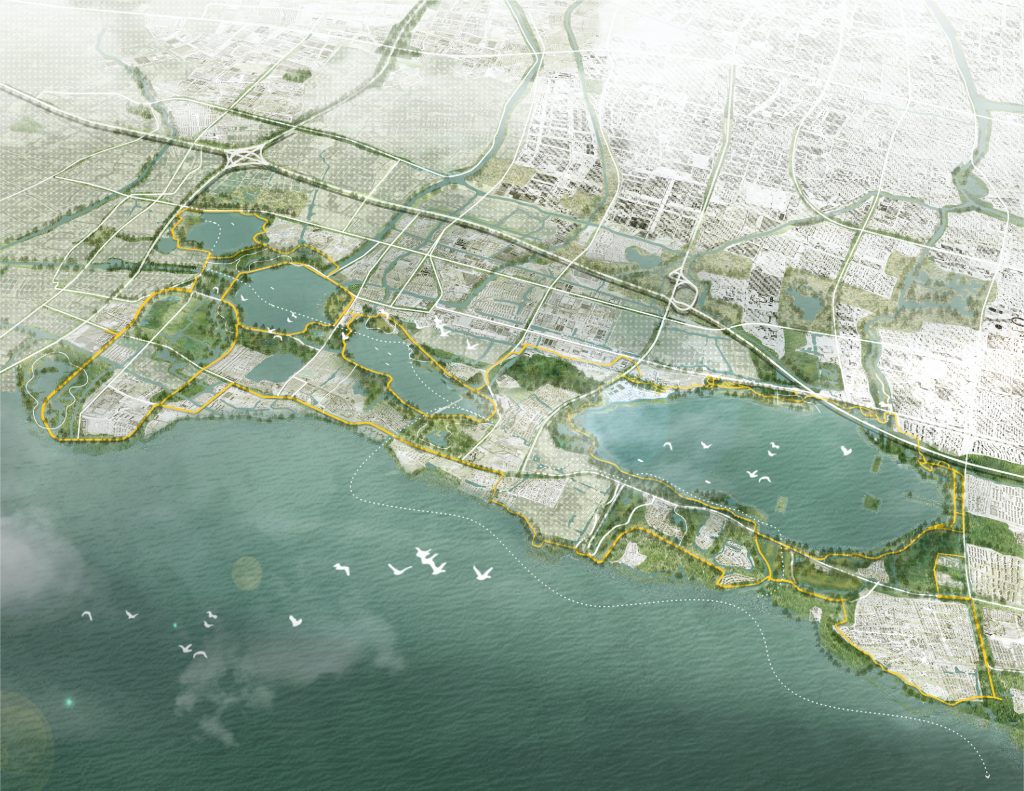
“The Kunshan Great Lake Park District Masterplan offers a sustainable framework for a vibrant future, addressing fragmented development, water pollution, and limited waterfront access. The landscape infrastructure phasing plan includes open space, greenway, blueway, and vehicular access strategies. The Great Lake Park District masterplan reflects a sophisticated approach to solving complex challenges, aligning with best practices in landscape architecture and urban design.”
This project can be viewed on PLAT’s website as well as on the ASLA website.
Buffalo Bayou Park and Promenade: SWA Group
Location: Texas, USA
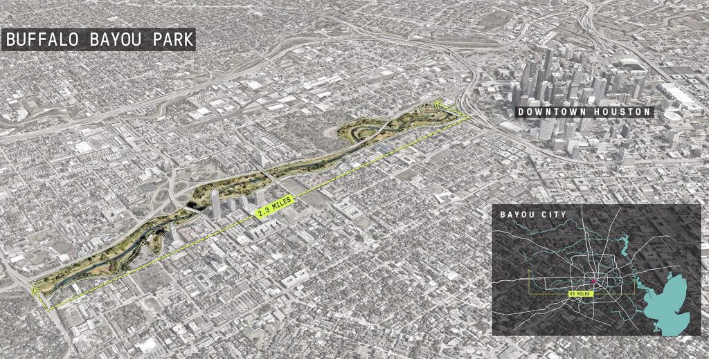
“The design utilizes channel stabilization techniques, enhancing the bayou’s natural meanders and offering increased resiliency against floodwaters while preserving the beauty of this culturally significant waterway. The planting strategy reduced mowed turf by half, replacing it with riparian woodlands and naturalized meadows featuring native species. This further stabilizes the landscape, provides habitat, and uses Texan species to return a sense of place to the city.”
This project can be viewed on Landezine and SWA’s website.