
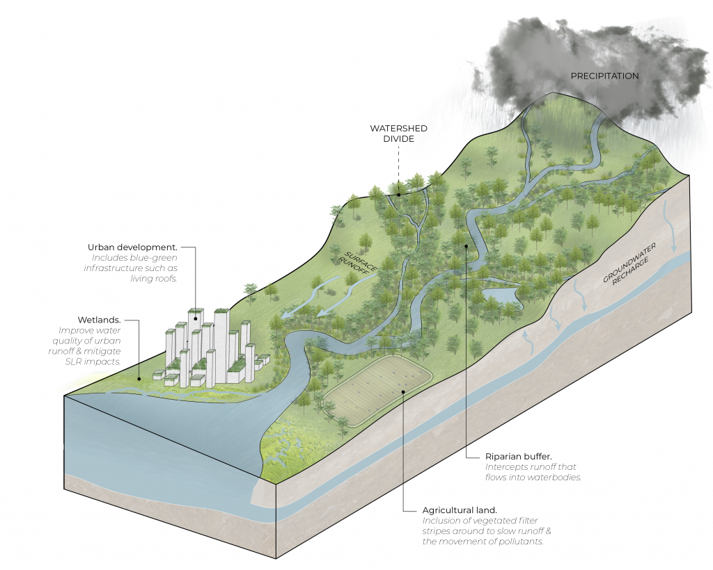
A watershed, also known as a drainage basin, is comprised of an area of land in which all precipitation and runoff drains towards the same body of water. A watershed is divided by its topographic ridge, or area of highest elevation, which acts to direct the flow of water to its basin outlet1.
[1] Letsinger et al., “Geohydrology.”
What are the components of a watershed?
The flow of water through the watershed is dictated by many characteristics, including the shape of the watershed, the topography, the geology, the soil composition, and land use and cover. Due to these variables, the composition of watersheds will vary, but includes streams, tributaries, groundwater, a receiving waterbody or basin outlet, and often sub-basins.1
Water is inputted into the watershed through precipitation or snowmelt, and then subsequently stored, converted into other forms, or diverted via runoff and streamflow. When water is stored, it occurs through water uptake by plants, through storage at the surface of soil, and via groundwater recharge. Water uptake occurs in varying capacities according to the amount or type of vegetative cover. A portion of the water uptake is later released into the water cycle through evaporation, transpiration, or evapotranspiration.2
[1] Letsinger et al., “Geohydrology.”
[2] Letsinger et al.
What are the current impacts on watersheds?
The urban environment has a tremendous impact on the functioning of watersheds, with the following stresses being induced:
- The loss of natural habitat, thus threatening biodiversity
- Heat islands
- The alteration of hydrological and biogeochemical cycles
- The introduction of pollutants into ground and surface water1
- Increased vulnerability in the event of natural disasters such as storms, floods, droughts, and landslides2
[1] Huang et al., “Patterns and Distributions of Urban Expansion in Global Watersheds.”
[2] Huang et al., “Patterns and Distributions of Urban Expansion in Global Watersheds.”
Why is it important to be aware of watersheds when designing?
The management of a watershed requires a multi-disciplinary approach, and because of this, it’s important as a designer to be aware of the broader system (watershed) that designs are situated within, as well as the impacts facing each respective watershed as each are unique in their composition. The link HERE provides the delineations of the watersheds within Canada at various scales.
As the impacts on watersheds are often experienced during pronounced climatic events, it is important to consider how designs will respond to such events, as the timing and intensity of these weather patterns themselves cannot be controlled. During periods of precipitation, for example, water can be taken up by plants, recharge groundwater, accumulate in areas where the water table is already high and the soil is saturated, or contribute to runoff.1 As such, below are a few important considerations:
- The placement of vegetation. Increased infiltration of water (through methods such as planting) helps reduce runoff, mitigate flooding, and increases the groundwater levels to reduce drought during periods of low precipitation. This is critical in areas of steep terrain as fast-moving water and instable slopes create the risk of landslides (insert hyperlink to landslide blog here). It is also critical along riparian buffers that intercept the runoff that will flow into aquatic systems2.
- Land use considerations. This includes both the topography (steepness of terrain in particular) and the varying land types that comprise watersheds. Some of the land types included in this assessment are agricultural land, forest land, urban areas, riparian zones, and waterbodies. The various land types are unique in their composition, yet all impact the health of the watershed and should therefore be considered holistically when undergoing watershed management. For example, agricultural lands are often high in water consumption and contribute pollutants into the watershed through their fertilization requirements. Interventions in agricultural lands may include vegetated filter strips to slow runoff and the movement of pollutants, as well as cover crops to improve soil health. They should be appropriately placed in consideration of the adjacent land type within the watershed3.
- Impermeable surfaces and the use of blue-green infrastructure. Urban development increases the amount and area of impermeable surfaces. This then diverts and increases runoff as water is unable to permeate through soil. Soil compaction is also increased, which similarly reduces infiltration and thus increases runoff. To mitigate these effects, designs can incorporate architectural solutions such as permeable surfaces and blue-green infrastructure4.
[1] Tomer, “Watershed Management.”
[2] Letsinger et al., “Geohydrology.”
[3] Tomer, “Watershed Management.”
[4] Tomer.
Sources
Huang, Qingxu, Han Zhang, Jasper Van Vliet, Qiang Ren, Raymond Yu Wang, Shiqiang Du, Zhifeng Liu, and Chunyang He. “Patterns and Distributions of Urban Expansion in Global Watersheds.” Earth’s Future 9, no. 8 (August 2021): e2021EF002062. https://doi.org/10.1029/2021EF002062.
Letsinger, Sally L., Allison Balberg, Elias Hanna, and Erin K. Hiatt. “Geohydrology: Watershed Hydrology.” In Encyclopedia of Geology, 442–56. Elsevier, 2021. https://doi.org/10.1016/B978-0-12-409548-9.12389-9.
Tomer, M.D. “Watershed Management.” In Reference Module in Earth Systems and Environmental Sciences, B978012409548909117X. Elsevier, 2014. https://doi.org/10.1016/B978-0-12-409548-9.09117-X.
Additional Resources
Watershed Characterization: City of Vancouver
This document that provides an overview of the City of Vancouver’s urban watersheds as well as insight into the various factors affecting their health and management.
Watershed Management by M.D. Tomer
This article provides an overview of the factors affecting watershed health, with an emphasis on how the role of water quality and land use contribute to and are affected by climatic events. In summarizing the complexity of issues facing watersheds, as well as the importance of considering local conditions, it provides an insight into watershed assessment and a brief methodology for how watershed management may be approached.
Precedents
San Francisco Bay Delta Watershed
Location: California, USA
“EPA addresses water pollution from the watershed approach, a comprehensive framework for addressing water resource challenges….Restoring water quality is most effective when pollution sources, stressors and solutions are identified for the entire watershed.”
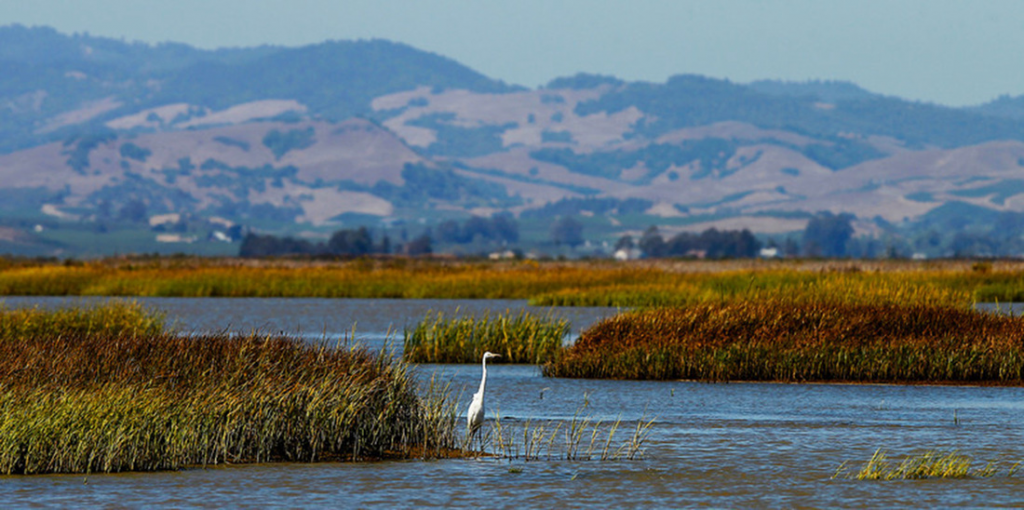
This project can be accessed here.
Erhai Lake Ecological Restoration Project: Arcplus & Zeho
Location: Dali, China
“The developed masterplan uses dynamic measures and methods in diverse scales to limit poor development practices and respond to social challenges, achieving maximal ecological benefit with minimal human intervention. With a multitude of government and local players, the project reinvigorates and monitors the entire watershed with waterscape management.”
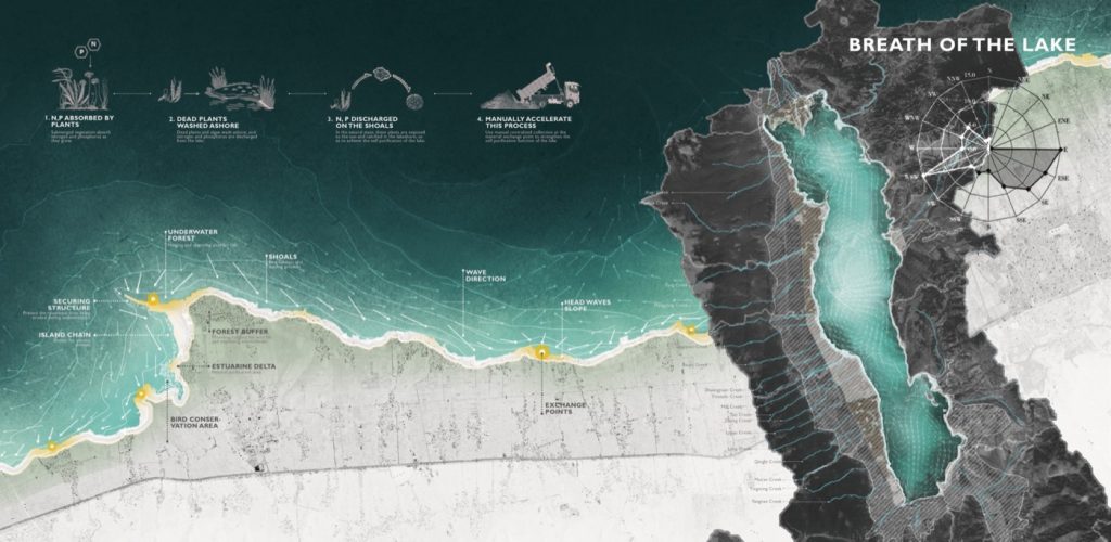
This project can be accessed on Landezine or via the IWA website.