Water and Biodiversity

As the world suffers from an ongoing biodiversity crisis, there is an urgent need for change.  Humans have driven a massive decline in biodiversity globally, of which an estimated 30% has been connected to habitat degradation through land use1

The way the environmental designers work with water is a critical piece in the puzzle of how land use is reimagined for a biodiverse future.  Understanding the complex relationship between biodiversity and water has been a major area of study for scientists across disciplines, providing ample data both to catalyze and guide the work of environmental designers in this area. 


[1] “What Is the Human Impact on Biodiversity?”

What is the relationship between biodiversity and water in the landscape? 

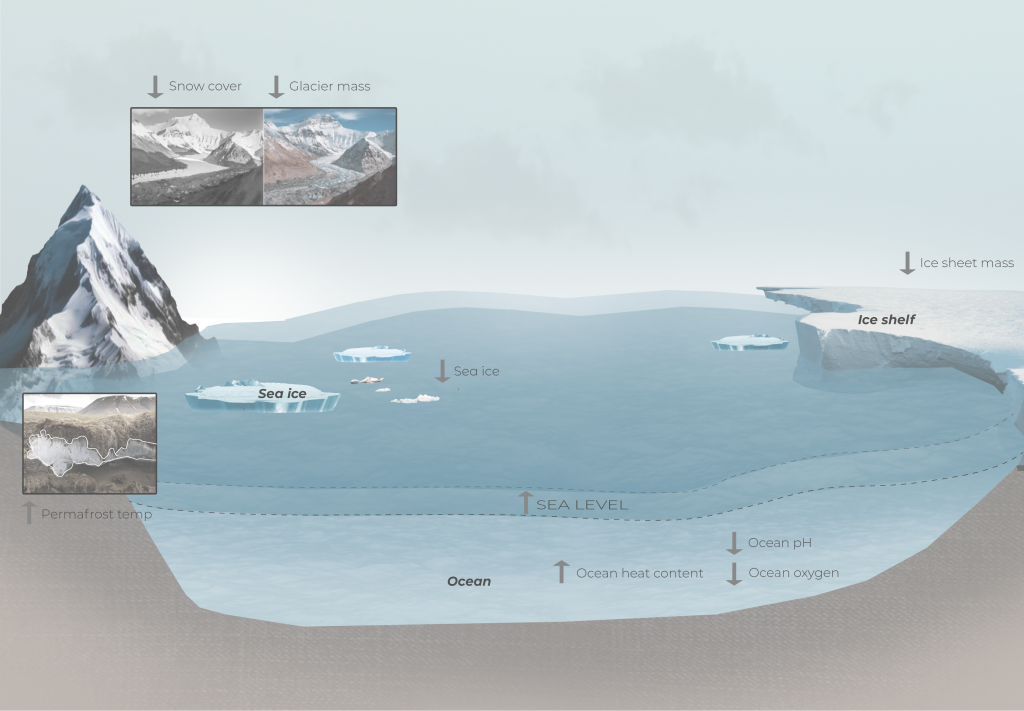
The relationship between water and biodiversity is not a one-way street.  The Global Biodiversity Outlook found that “biodiversity is directly implicated in maintaining most ecosystem functions that deliver [water-related] services, but it is also a co-beneficiary of improved ecosystem conditions”1.  Biodiverse ecosystems tend to manage water well because of their biodiversity, while simultaneously, landscapes with consistent and available water tend to support a higher degree of biodiversity.   

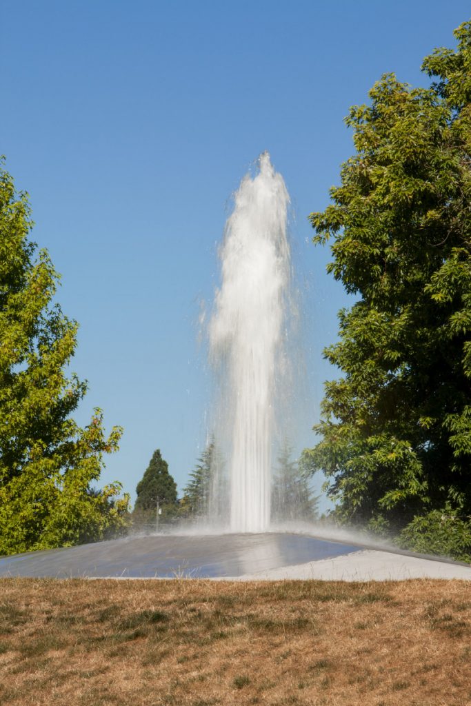
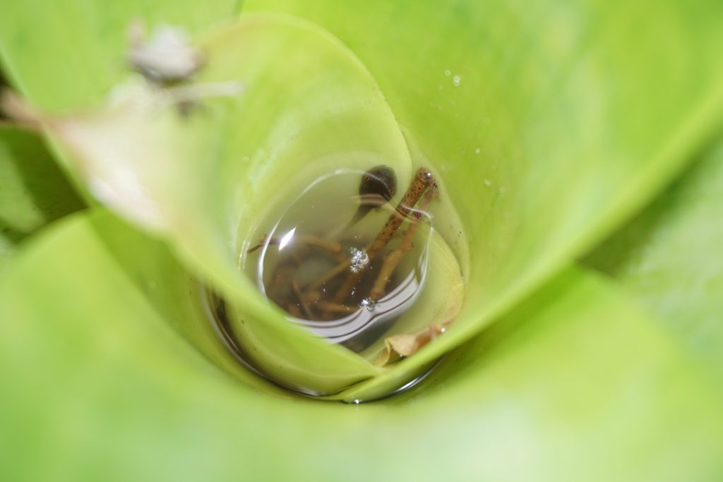
One of the most apparent markers of rich biodiversity in a landscape is the presence of water.  While in some cases the presence of water is obvious and significant, such as rivers, oceans, lakes, and streams, even large plant leaves collecting a few droplets of dew or a small depression filling with water after a rain can have a significant impact on the presence of wildlife nearby.   

The quality of available water in a landscape is directly tied to biodiversity.  As mentioned above, biodiverse ecosystems tend to manage water well, and in this case, biodiversity can create the conditions necessary to maintain water quality.  In this way, biodiversity performs an ecosystem service that is self-regulating, and can benefit humans as well.  Reduction of biodiversity can have a negative effect on water quality, which in turn drives further loss of biodiversity.  For more information on water quality, please visit the Water Quality blog page. 

The different states and conditions of water also impact biodiversity.  For further information, please visit any of the following ecosystem-specific blog pages: Wetlands, Intertidal Zone, Lotic Ecosystems, Lentic Ecosystems, and Riparian Zones. 


[1] Secretariat of the Convention on Biological Diversity, “Water and Biodiversity.”

How can environmental designers maximize biodiversity through water? 

As environmental designers reimagine land use in the decades to come, we have a significant responsibility not just to reduce harm, but also to revitalize landscapes for biodiversity, both through large scale planning and conservation measures, as well as through smaller interventions and networks.  Since we know that biodiversity and water are intricately co-dependent, improvements to water quality and systems must occur as an integral part of all efforts to increase or safeguard biodiversity.  Understanding how to maximize biodiversity within the scale and constraints of a project through water is a helpful starting point.  Here is a selection of considerations: 

Research, and work with experts on local plants, animals, and ecology to develop water-based plans that respond to site-specific ecological needs.  

Understand what is beyond the site.  Both water and life are almost never confined to a project site, so understanding water regimes (see the Watersheds blog page) as well as large-scale ecosystems that surround a site is a critical part of integrating into a network of biodiversity, especially with limited-impact small-scale projects. 

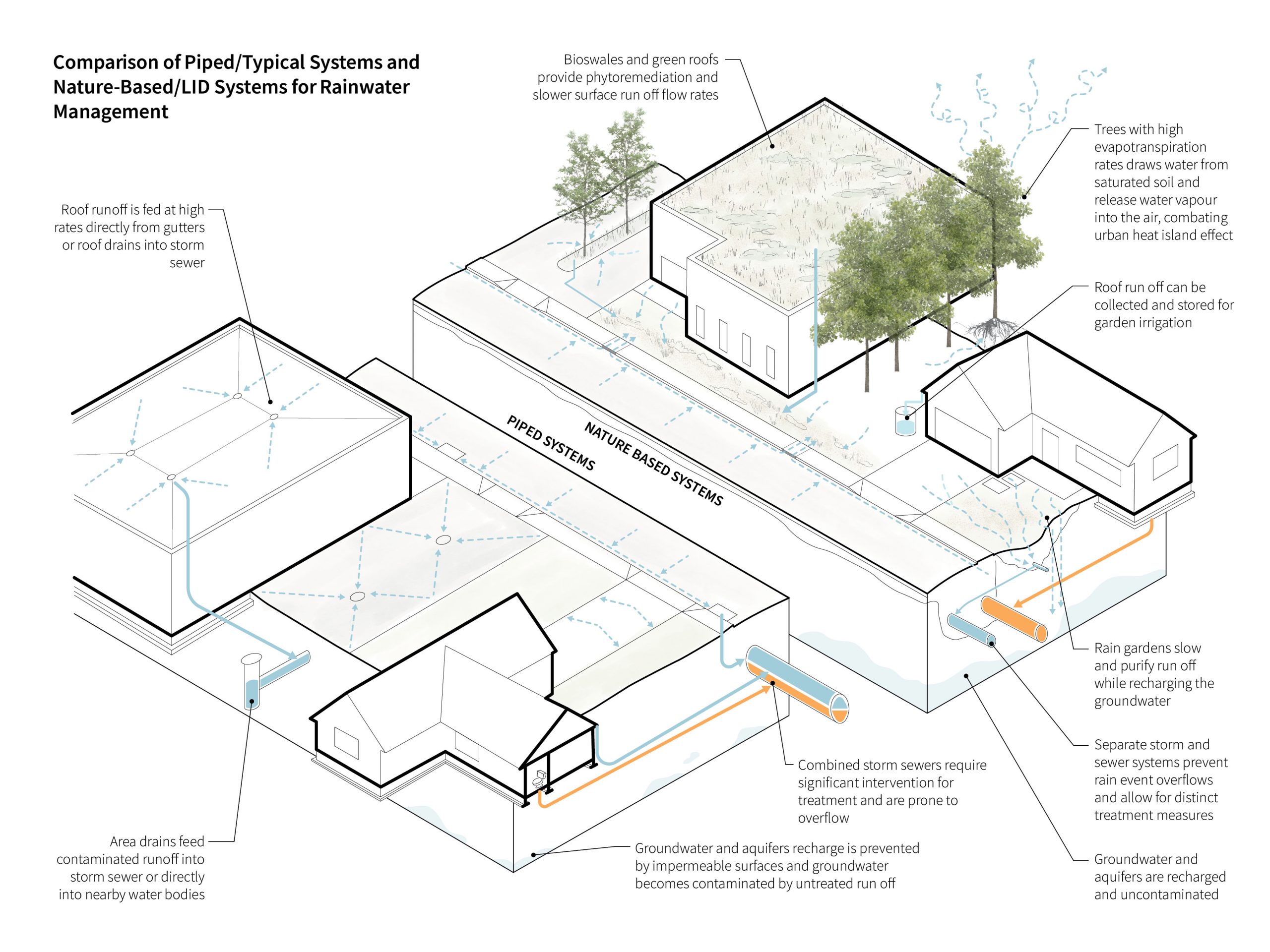
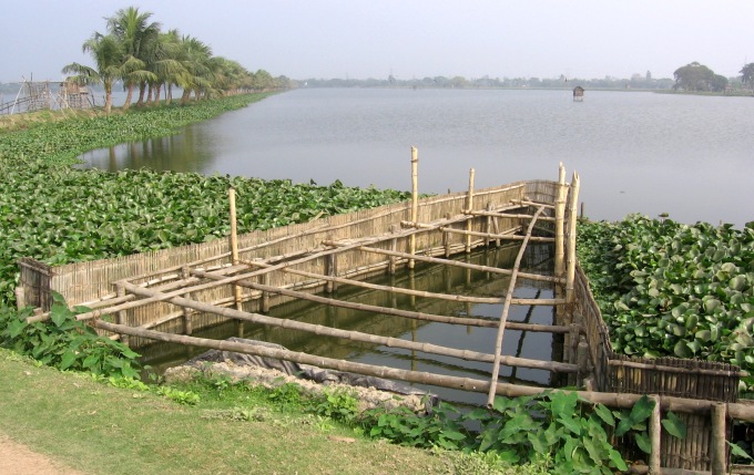
Add and improve sources or collection points for water in designed landscapes, one of the most impactful moves to increase or maintain local biodiversity.  This can occur across scales, from adding plants that collect dew droplets for insects in an urban front yard, to daylighting streams or planning city-wide networks of rain gardens (see the Rainwater Management blog page).   

Improve water quality.  Often, biodiversity loss in aquatic or near-aquatic ecosystems is related to degradation of water quality.  Starting with water quality ensures that biodiversity increases can be sustained by that which it relies on, while finishing with ecology ensures that the new level of water quality can be maintained.  

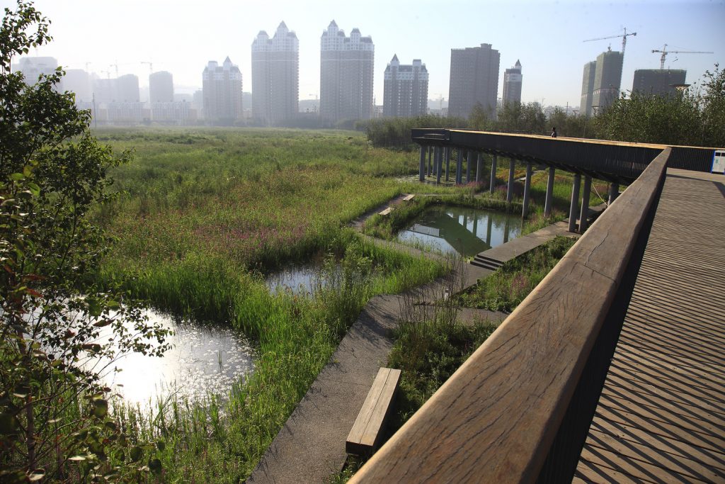
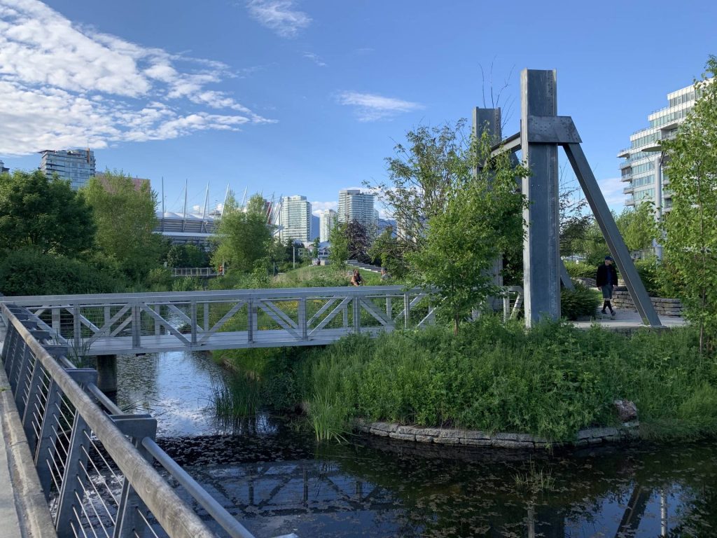
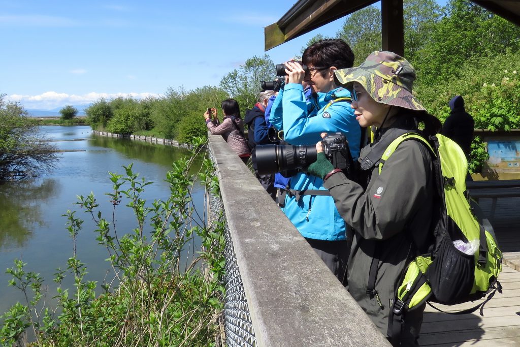
Provide regulated access to watery ecosystems.  While the presence of humans may not seem like a key factor in increasing biodiversity, providing safely considered access to biodiverse ecosystems, along with educational programs, can help people experience firsthand the importance of a landscape and of biodiversity, prompting future generations to care better for the land around them. 

Sources

Secretariat of the Convention on Biological Diversity, “Water and Biodiversity: Summary of the Findings of the Fourth Edition of the Global Biodiversity Outlook as They Relate to Water,” 2015, https://www.cbd.int/gbo/gbo4/gbo4-water-en.pdf

“What Is the Human Impact on Biodiversity? | Royal Society.” https://royalsociety.org/topics-policy/projects/biodiversity/human-impact-on-biodiversity/.

Images

Figure 1: Jones, Adam. “Disruption to Tiny Life Can Lead to Big Changes in Warmer Climate.” University of Alabama News (blog), October 12, 2020. https://news.ua.edu/2020/10/disruption-to-tiny-life-can-lead-to-big-changes-in-warmer-climate/.

Burke Mountain Naturalists. “Field Trip to Reifel Bird Sanctuary May 2017,” May 31, 2023. https://www.burkemountainnaturalists.ca/photos/field-trip-to-reifel-bird-sanctuary-may-2017/.

Additional Resources

Landezine. “Dr. Stephan Brenneisen: Living Roofs – Biodiversity and Water Retention by Design Measures.” https://landezine.com/dr-stephan-brenneisen-living-roofs-biodiversity-and-water-retention-by-design-measures/.

A video lecture that focusses on methods for creating biodiverse green-roofs.


Brezar, Zas. “The Cute, the Bad and the Ugly – On Urban Biodiversity and Ecological Aesthetics.” Landezine. https://landezine.com/the-cute-the-bad-and-the-ugly-on-urban-biodiversity-and-ecological-aesthetics/.

An opinion piece that outlines the relationships between biodiversity and the aesthetics of designed spaces in urban centers.

Precedents

xʷəyeyət – Iona Island: space2place

Richmond, BC, Canada

A concept image from space2place that illustrates biodiversity considerations on a portion of Iona Spit.

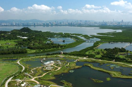
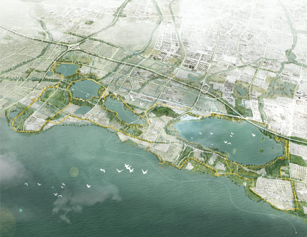
xʷəyeyət / Iona Island is an extensive re-imagination of Vancouver’s waste water treatment facility and the surrounding landscape that aims to remediate ecological, geological, and cultural harm done by previous alteration to the landscape.

Project can be viewed here.


Pollinator Passages: ByBi, multiple community participants
Oslo, Norway

Two Snøhetta-designed bee hives on an Oslo rooftop, part of a network of habitat and food sources for pollinators in the city. Photo credit Visit Norway.

A community-led initiative, pollinator passages aims enlists “urban dwellers, professionals, neighborhoods, municipal agencies, organizations and businesses to help create good habitats and thriving routes for pollinators across the entire city” of Oslo. Variably scaled interventions and helpful resources make this initiative easy for many to participate in, helping to restore this critical aspect of biodiversity in a growing urban center.

This project can be viewed here and here.

The Basics

If there is one substance that sets our planet apart in the known universe, it is water.  It is simultaneously ubiquitous, as Anuradha Mathur & Dilip da Cunha say1, and singular in its importance to life on earth.  At its most basic, water is a polar molecule consisting of one oxygen and two hydrogen atoms.  Water has several basic characteristics that should inform how we understand its role in design and in the landscapes we design in: 

  1. Water is present in solid, liquid, and gas.  While the work of landscape architects and designers tends to focus on liquid water, solid and gaseous water must also be considered.  Water changes between states as a result of temperature change altering the strength of hydrogen bonding between molecules: water vapour occurs when high heat breaks hydrogen bonds, liquid water occurs when mild temperatures allow to hydrogen bonds to form, break, and reform; and ice occurs when very low temperatures allow hydrogen bonds to remain fixed.  Unlike many substances, when water freezes into ice it becomes crystalline and less dense, which allows ice to float on water’s surface.   
  2. Water is a solvent.  Liquid water has the ability to carry many dissolved substances in it.  This characteristic is one of the primary ways by which life-giving nutrients travel through and between ecosystems.  It is also how harmful contaminants can spread out from a single source.  
  3. Water is a temperature regulator.  This is because water takes significantly more energy to heat up than air.  This is why areas near the ocean or large lakes tend to have milder climates than areas further from water.  This characteristic of water can be used effectively to combat extreme heat events and urban heat island effect, for example. 
  4. Water is cohesive and adhesive. Cohesion allows water molecules to hold on to each other, which results in phenomena such as surface tension and the forming of droplets.  Also involved in the forming of droplets is adhesion, which allows water molecules to hold to other molecules around them2.    

The states and characteristics of water help determine the global water cycle, by which water evaporates, condenses, transports, precipitates, infiltrates, and flows3. The water cycle is an critical part of global weather patterns.

However, the wonder of water goes far beyond its chemical and physical characteristics. It is both a necessity for life and a focal point of thought. Few other elements occupy the intersection of practical needs and cultural imagination so thoroughly. Environmental designers must be deeply considerate of this intersection when designing with water: water-informed designs must respond to the physical characteristics of water and the pragmatic needs of site, occupants, and ecosystems all within the local cultural environment. This blog aims to encourage this holistic, site-informed design by initiating thought and conversation on a series of related topics which are by no means exhaustive. The particularities of watery landscapes are numerous, and ripe for discovery by environmental designers equipped with curiosity and thoughtful questions. 


[1] Mathur and da Cunha, “Wetness Is Everywhere.”

[2] Khan Academy, “Lesson Summary: Water and Life”

[3] Sciencing, “The Role of Water in the Ecosystem”

Sources

Khan Academy. “Lesson Summary: Water and Life.” https://www.khanacademy.org/search.

Khan Academy. “The Water Cycle.” https://www.khanacademy.org/_render.

Mathur, Anuradha, and Dilip da Cunha. “Wetness Is Everywhere.” Journal of Architectural Education 74, no. 1 (January 2, 2020): 139–40. https://doi.org/10.1080/10464883.2020.1693843

Sciencing. “Role of Water in the Ecosystem.” https://sciencing.com/role-water-ecosystem-5444202.html.

Additional Resources

Sciencing. “Role of Water in the Ecosystem.” https://sciencing.com/role-water-ecosystem-5444202.html.

Water and Architecture

While much of water-informed design lies within the realm of landscape architects and urban designers, architects also have a major role to play, especially in densely built urban centers.  Within a building, water-informed design can lead to enhanced sustainability and lowered energy and water use while generating more livable interior spaces.  Integration of architecture and landscape, a critical aspect of environmental design, can be achieved more holistically with water as a guide. 

How does water play a role in Architecture? 

The basics of water and architecture can be organized in two simple categories: Inside and Outside 

Water inside architecture involves hot and cold drinking water, wastewater (greywater and blackwater), and may also include specialized water systems such as fire suppression, aesthetic applications, or water-based heating and cooling.  While this blog cannot cover the details of all these systems, it is important to note that each one has standard, widely accepted methods of application that may be creatively tweaked to improve performance, sustainability, energy use and integration through collaborative design with engineers.  For example, heat from shower-drain wastewater can be captured to aid in maintaining comfortable building temperatures, or grey water from sinks can be re-used to flush toilets.  Understanding the full range and scale of water systems required at the schematic design phase of a building is critical to implementing these changes and devising water plans that decrease energy and water use while simultaneously increasing livability and design excellence.   

Water outside architecture involves the structures and systems used to keep a building’s interior dry.  At its most basic, this includes rainscreens, roofing, and drainage systems.  There are thousands of options, both traditional and contemporary, for materials and build-ups for both roofing and rainscreens.  These can be chosen or developed based on the building’s site-specific climate.  Understanding the year-round water regime and climate of a site is critical in selecting the highest performing rainscreens and roofs while balancing embodied carbon.   

A specific roofing type that has gained significant attention in recent years is the green roof.  Green roofs use plants and soil above waterproofing layers to capture or slow down the flow of rainwater runoff from a building.  This not only has a positive impact on the surrounding rainwater management systems, but also serves to reduce heat island effect, reduce energy use for interior cooling, purify the air, and support urban biodiversity1.  Green roofs can be on a spectrum between extensive or intensive.  Extensive green roofs involve smaller plants in shallower soil, with a lighter structural requirement and usually less maintenance.  Intensive green roofs have deeper soil layers and may include shrubs and trees, along with pathways and occupiable space.  These may require irrigation during drier seasons (Lampert 2019).  For further information on green roofs and how they connect with other nature-based rainwater systems, please visit the Rainwater Management blog page. 


1. US EPA, “Using Green Roofs to Reduce Heat Islands.”

2. Lampert, “A Guide to Green Roofs.”

How can inside and outside water systems be integrated? 

Integration of inside and outside water systems can reduce water and energy use, improve quality of life, reduce environmental impact, and meaningfully integrate a building into its surrounding context.  There are numerous precedents of novel ways architects and landscape architects have integrated indoor and outdoor systems.  One of the most common ways is rainwater capture and reuse, whereby a buildings drainage systems collect rainwater to store, either using it outright to flush toilets or irrigate surrounding gardens or purifying it for potable water uses.  Within a building, separating greywater and blackwater systems can allow for greywater to be recycled, both internally and externally, and could contribute to water elements in the surrounding landscape.  This also reduces the volume of water entering sewers.  Note that there are often municipal bylaws that govern the recycling of greywater and rainwater.  During the schematic design phase of a building, it is important that architects and landscape architects together devise ways that inside and outside water systems can be woven together in a way that contributes to the surrounding context. 

Inside, outside, and linked water systems can also be used to generate and inform the aesthetics of architecture. Architects have employed water aesthetically for thousands of years, often linked to the way that water impacts light.

Sources

Lampert, Eve. “A Guide to Green Roofs: The Lowdown on Types, Components and Advantages,” April 18, 2019. https://greenbuildingcanada.ca/guide-to-green-roofs/

US EPA, OAR. “Using Green Roofs to Reduce Heat Islands.” Overviews and Factsheets, June 17, 2014. https://www.epa.gov/heatislands/using-green-roofs-reduce-heat-islands

Global Water. “Difference between Blackwater and Greywater.” https://www.globalwatergroup.com.au/our-blog/difference-between-blackwater-and-greywater. 

Additional Resources

Architizer. “Let It Pour: 8 Architectural Details to Harvest Rainwater” June 29, 2018. https://architizer.com/blog/inspiration/collections/rainwater-collection/

A series of helpful precedents where water collection is incorporated meaningfully into a building’s design.


Elemental Green. “The Complete Beginner’s Guide to Greywater Systems,” October 21, 2016. https://elemental.green/complete-beginner-guide-to-greywater-systems/

The basics of greywater reuse, with helpful point-form notes to guide design of systems.


Olshavsky, Peter. “Allure of Water: An Interview with Steven Holl.” Journal of Architectural Education 74, no. 1 (March 12, 2020): 149–53. https://doi.org/10.1080/10464883.2020.1693847.

An interesting interview, mostly focus on the aesthetic qualities of water in architecture.


Roehr, Daniel and Fassman-Beck, Elizabeth. Living Roofs in Integrated Urban Water Systems. London: Routledge, 2015. https://doi.org/10.4324/9781315726472.

A crossover resource also on the Rainwater Management blog, illustrating the role that green roofs play in larger urban landscapes.


Wilson, Alex. “Rainwater Harvesting.” BuildingGreen, May 1, 1997. https://www.buildinggreen.com/feature/rainwater-harvesting

The basics of rainwater harvesting, including some historic methods.

Precedents

Hillcrest Geyser: Vanessa Kwan, Erica Stocking

Location: Vancouver, BC, Canada

An artificial geyser installed near a community center interrupts the flow from municipal water sources, indicating each time that the building draws on city water to supplement its extensive grey water and rain water re-use system.

Project can be viewed here and here.


On the Brooks House: Monsoon Collective
Angamaly, India

At the residential scale, this house draws the flow of rainwater runoff right through the building, centralizing that ephemeral, seasonal experience for the residents.

This project can be viewed here.

Rainwater Management

Management of runoff during rain events has become one of the most critical – if overlooked – aspects of urban infrastructure.  Since Roman times, we have been “plumbing” our urban watersheds: piping runoff and pulling it away from streets and buildings as quickly as possible.  Over the last century, our urban centers have grown larger and more impermeable, while rain events have increased in their extremity as a result of climate change, exposing glaring faults in our urban rainwater management systems.  It is imperative that designers of urban spaces understand the state of existing water infrastructure, design across scales for resilience in the face of change, and champion new ways of relating to rainwater in urban contexts. 

What are some historical approaches to rainwater management?

The watershed is nature’s rainwater management system.  Complex systems of geographical and biological forces shape and are shaped by flow of water, from raindrop to ocean.  Natural watersheds are dynamic – constantly changing in response to variations.  Their dynamic structure makes natural watersheds highly resilient in the face of climate change.  Click here to dig deeper into the topic of watersheds. 

Everywhere on earth bears a relationship to a natural watershed, including our most urbanized cities.  However, urbanization has almost always resulted in alteration and often degradation of natural watersheds through the implementation of engineered infrastructure for rainwater management, “disregarding the local environment and the natural limits of each place”1.  For example, A small, meandering creek might be replaced by a straight underground culvert or pipe, fed by surface drains.  In this way, the creek is viewed as providing a single, replaceable service, and its physical and biological characteristics are overlooked.   

As a result, the majority of urban stormwater infrastructure is underground, out of public view, focused exclusively on getting excess water out of the city and into nearby lakes, rivers, and oceans. Above ground, cities are often characterized by hard, impermeable surfaces such as roads, plazas, sidewalks, and roofs.  Water runs off these surfaces into drains, which lead to pipes that carry the water away.   

These systems have three overarching impacts on the natural health of urban areas: reduced biodiversity, depleted ground water/aquifers, and system overflow. 

Reduced biodiversity: the presence of moving and still water is directly correlated with enhanced biodiversity (citation needed).  Surface creeks and streams are critical areas of habitat for fish especially.  For example, urbanization along the west coast of North America can be directly tied to the depletion of the salmon fishery over the last century due to the piping of spawning streams.  Click here to learn more about riparian habitats. 

Depleted ground water/aquifers: Natural watersheds have the ability to replenish ground water through permeable surfaces and standing water.  Impermeable urban areas and extensive piping of runoff prevent this natural recharging of groundwater and aquifers, many of which we rely on for our own drinking water2.   

System overflows: Many urban stormwater management systems are called combined sewers, which means that both sewer water and runoff are transported in the same system of underground pipes, all to be purified at water treatment facilities.  These treatment facilities have a maximum capacity and are prone to being overwhelmed during significant rainfall events.  In most cities, the result is combined untreated sewage and runoff overflowing into oceans and rivers through sewer outfalls, causing massive contamination3.   

When engaging a project, it is critical to understand the paths that runoff has taken on its way to and from your site through history – whether through creeks or pipes – and the paths that it takes today. 


1. Cahill, Low Impact Development and Sustainable Stormwater Management.

2. Pukhtoon, “Urban Development and Its Impact on the Depletion of Groundwater Aquifers…”

3. US EPA, “Combined Sewer Overflows (CSOs).”

What are some resilient options for rainwater management? 

In the face of failing infrastructure and changing climate, environmental designers are at the forefront of developing a resilient future, regardless of project scale.   

In the creek-to-pipe example above, the physical and biological characteristics of the creek were ignored in favor of its function of getting water from A to B. Many landscape architects and civil engineers have been returning to the physical and biological side of watersheds in search for solutions to our failing urban infrastructure, launching a field of research and design called Low Impact Development (LID).   

LID (also occasionally referred to as Green Infrastructure or “GI”1) focusses on nature-based rainwater management systems, with emphasis on multi-benefit interventions and at-grade infrastructure, rather than single-purpose, below grade solutions.  The principals of LID have been exercised across scales and are becoming more and more common in urban centers as a novel way of managing runoff.  While LID is best viewed as a holistic, mass-scale approach, variations in the scale of interventions make it a helpful tool for understanding the impact a single project can have on the city as a whole.   

Figure 1. Comparison of Piped/Typical Systems and Nature-Based/LID Systems for Rainwater Management.

Smaller scale interventions, such as rain gardens, bioswales, and green roofs, focus on slowing and filtering runoff.  This helps reduce the load on drains and combined storm sewer systems during heavy rain events; one of the critical principals for LID is managing rainwater right where it falls2. It is important to note that these small interventions are not simply technological and solution-focused, but rather are multi-benefit, enriching the ecology and multisensorial experience of a landscape at human scale3.   

Medium scale interventions are often focused on capturing rainwater for future use or recharging groundwater and aquifers.  Examples at this scale include rainwater storage vaults, permanent retention ponds, permeable surfacing, and infiltration areas. 

Large scale interventions aim at retrofitting urban infrastructure.  For example, separation of sewer and storm water systems, large scale phytoremediation, reuse of rainwater in plumbing services (see also Water and Architecture), and daylighting streams. 

Take a look at the following table for further examples of LID-based interventions across scales. 


1. “Terminology of Low Impact Development.”

2. Cahill, Low Impact Development and Sustainable Stormwater Management.

3. Dunnet and Clayden, Rain Gardens.

How can Environmental Designers cultivate a new relationship with rainwater? 

As LID-based projects bring water back into the public eye, there are new opportunities to build a more positive relationship with rainwater in urban centers.  Beyond providing better function, daylighting our rainwater management infrastructure can reconnect a city and its inhabitants to the reality of where water goes, the history of the local watershed, and the biodiversity urban spaces are capable of supporting.  Renewed presence of water encourages innovation and conversation, leading to novel ways of incorporating rainwater into daily public and private life.  Designers of urban environments have a responsibility to engage and educate the public on these issues, both through design and engagement 

Sources

Cahill, Thomas H. Low Impact Development and Sustainable Stormwater Management. John Wiley & Sons, Ltd, 2012. https://doi.org/10.1002/9781118202456.app1.

Dunnet, Nigel, and Andy Clayden. Rain Gardens: Managing Water Sustainably in the Garden and Designed Landscape. Portland, Oregon: Timber Press, 2007. https://www.academia.edu/download/61941210/0881928267_Rain_Gardens_Managing_Water_Sustainably_in_the_Garden_and_Designed_Landscape20200130-128986-bfi20g.pdf.

Pukhtoon, Yar. “Urban Development and Its Impact on the Depletion of Groundwater Aquifers in Mardan City, Pakistan.” Groundwater for Sustainable Development 11 (October 2020). https://doi.org/10.1016/j.gsd.2020.100426.

“Terminology of Low Impact Development: Distinguishing LID from Other Techniques That Address Community Growth Issues.” United States Environmental Protection Agency, 2012. https://www.epa.gov/sites/default/files/2015-09/documents/bbfs2terms.pdf.

US EPA. “Combined Sewer Overflows (CSOs).” Overviews and Factsheets. National Pollutant Discharge Elimination System, October 13, 2015. https://www.epa.gov/npdes/combined-sewer-overflows-csos.

Additional Resources

Cahill, Thomas H. Low Impact Development and Sustainable Stormwater Management. John Wiley & Sons, Ltd, 2012. https://doi.org/10.1002/9781118202456.app1.

An extensive and detailed textbook resource helpful for gaining further knowledge on LID strategies and principles.


Dunnet, Nigel, and Andy Clayden. Rain Gardens: Managing Water Sustainably in the Garden and Designed Landscape. Portland, Oregon: Timber Press, 2007. https://www.academia.edu/download/61941210/0881928267_Rain_Gardens_Managing_Water_Sustainably_in_the_Garden_and_Designed_Landscape20200130-128986-bfi20g.pdf.

A useful companion when designing all scales of rain gardens. This book includes the basic science of rain garden infrastructure along with precedents and strategies helpful for environmental designers.


Lim, H. S., and X. X. Lu. “Sustainable Urban Stormwater Management in the Tropics: An Evaluation of Singapore’s ABC Waters Program.” Journal of Hydrology 538 (July 1, 2016): 842–62. https://doi.org/10.1016/j.jhydrol.2016.04.063.

This resource provides a glimpse at strategies used for rainwater management in tropical countries, as well as an evaluation of an extensive policy program.


“Rain City Strategy: A Green Rainwater Infrastructure and Rainwater Management Initiative.” City of Vancouver, 2019. https://vancouver.ca/files/cov/rain-city-strategy.pdf.

This is the City of Vancouver’s overarching strategy to incorporate nature-based systems in new development and the existing urban fabric. Rain City Strategy is a helpful example of water-based public policy made accessible for both environmental designers and the general public.


Roehr, Daniel and Fassman-Beck, Elizabeth. Living Roofs in Integrated Urban Water Systems. London: Routledge, 2015. https://doi.org/10.4324/9781315726472.

A crossover resource also on the Water and Architecture blog, illustrating the role that green roofs play in larger urban landscapes.


Greenskins Lab. “Holistic Stormwater Management Application.” 2019. https://onedrive.live.com/?authkey=%21AGviy%5FdQiRBQQbQ&cid=E11813022BBE528C&id=E11813022BBE528C%218872

A helpful spreadsheet-based tool developed by Greenskins lab to visualize the calculations required for LID methods.

Precedents

Qunli Stormwater Wetland Park: Turenscape
Location: Haerbin, China

A 34 hectare park that collects, filters, and infiltrates stormwater from the surrounding urban fabric, while providing wildlife habitat and recreational access opportunities.

Project can be viewed here.


Hinge Park and South East False Creek: PWL Partnership, collaborators
Vancouver, BC, Canada

Hinge Park is the focal point of both rainwater management and natural public space in Southeast False Creek. Photo credit PWL Partnership.

Completed for the Vancouver 2010 Olympics, this neighbourhood was designed “as a natural watershed that collects rainwater and uses natural methods to retain and filer runoff prior to discharge into False Creek.”

The Project can be viewed here.

Sea Level Rise

The current projection of the global mean sea level rise is an increase between 0.43m and 0.84m by 2100, with a continuous increase for centuries to come.1


[1] “Technical Summary — Special Report on the Ocean and Cryosphere in a Changing Climate.”

What are the contributing factors to sea level rise?

The sea levels of the world’s oceans are currently on the rise due to the following contributing factors:

  • Rising temperatures caused by carbon emissions leading to ocean thermal expansion
  • The melting of glaciers and ice caps
  • The melting of the ice sheets of Greenland and Antarctica

The impacts of sea level rise are not evenly spread and will vary across regions, particularly due to subsidence from human activity which will result in a higher sea level within these areas, thus increasing their vulnerability.1


[1] “Sea-Level Rise from the Late 19th to the Early 21st Century | Surveys in Geophysics.”

What are the impacts on ecosystems and people?

In coastal regions, the impacts of sea level rise include erosion, flooding, salinization, loss of habitat, and a decrease in habitat function and biodiversity. The carbon emissions causing ocean warming are also increasing acidification and oxygen loss, thereby impacting aquatic ecosystems. This has contributed to large-scale coral bleaching and reef degradation as well as a reduction in the biodiversity of intertidal zones, specifically rocky reefs, in which species are particularly sensitive to rising temperatures and acidification. In estuaries specifically, the increase in nutrients and organic matter have increased eutrophication and have led to the enlargement of hypoxic areas.1

Along with the impacts to landscapes, the impacts extend to urban areas as the changes in temperature, oxygen levels and acidity have produced algal blooms and the occurrence of pathogens which impact food provisioning and human health. With sea level rise, there is also a global impact on food security, especially in low latitude, developing coastal communities who rely on seafood for nutrient requirements (Central and West Africa). Furthermore, there are cultural implications for many communities who have strong connections with the natural habitat of their regions and who come to rely on the harvesting of marine life for cultural and spiritual purposes, in addition to sustenance. Indigenous communities are particularly vulnerable as the reliance on the ocean for their livelihoods and culture is shifting and affecting their ability to pass on traditional knowledge or use their traditional harvesting techniques. Additionally, economies are affected through the impact on fisheries, marine tourism, and coastal buildings and infrastructure.2


[1] “Chapter 5: Changing Ocean, Marine Ecosystems, and Dependent Communities — Special Report on the Ocean and Cryosphere in a Changing Climate.”

[2] “Chapter 5: Changing Ocean, Marine Ecosystems, and Dependent Communities — Special Report on the Ocean and Cryosphere in a Changing Climate.”

How can designers respond to the threat of rising sea levels through designs and interventions?

Designers may respond to rising sea levels through a few different strategies.

The first of which is to create hard protection against water inundation through flood barriers such as levees, dikes, seawalls, breakwaters, and jetties. These are often found in urban coastal areas but have drawbacks that include the destruction of intertidal habitat through processes such as coastal squeeze and technical limits that constrain their effectiveness.

Designers may also modify buildings themselves through the elevation of structures and important utilities and through waterproofing.

A third strategy is through ecosystem-based adaptations, including both coral and wetland conservation. While wetland conservation and restoration preserve these essential intertidal habitats, these processes require a large portion of land, and are therefore not always feasible.

Lastly, designers can use coastal retreat through planned relocation of buildings or communities in areas where sea level rise is an immediate threat.1


[1] “Technical Summary — Special Report on the Ocean and Cryosphere in a Changing Climate.”

Sources

“Chapter 5: Changing Ocean, Marine Ecosystems, and Dependent Communities — Special Report on the Ocean and Cryosphere in a Changing Climate.” https://www.ipcc.ch/srocc/chapter/chapter-5/.

“Sea-Level Rise from the Late 19th to the Early 21st Century | Surveys in Geophysics.” https://link.springer.com/article/10.1007/s10712-011-9119-1.

“Technical Summary — Special Report on the Ocean and Cryosphere in a Changing Climate.” https://www.ipcc.ch/srocc/chapter/technical-summary/.

Additional Resources

Precedents

South Bay Sponge: Field Operations

Location: California, USA

Figure 2. South Bay Sponge (Santa Clara + San Mateo County) – Bay Area: Resilient by Design Challenge.

“The South Bay Sponge is an innovative model for how to adapt our urban coastal areas in the face of climate change, as many cities around the world face unprecedented threats from rising sea levels with increased flooding and related storm damage to infrastructure and settlement.”

This project can be viewed on the Field Operations website and through Rebuild By Design.


Hafencity Hamburg: HafenCity Hamburg GmbH

Location: Hamburg, Germany

As an alternative to dikes HafenCity has fallen back on the settlement pattern traditional in the North Sea area, the “Warft”…The “Warft” model protects HafenCity’s residents, workers and visitors even in the case of severe flooding. Even during the strong storm surges that occur about twice a year today, city life on the “Warft” can continue largely unaffected. The promenades are only flooded for a brief period.”

This project can be viewed on the city’s website and here.

Drought

In the 2022 Global Natural Disaster Assessment Report, the natural disaster affecting the highest percentage of people were droughts, with over 100 million people impacted and thousands of fatalities as a result1. According to the WHO, up to 700 million people may be at risk of displacement due to droughts by the year 20302. Across the globe, the impacts of droughts are increasing. In developing nations in particular, droughts have tremendous consequences, as they can lead to famines and political instability3.  


[1] “2022 Global Natural Disaster Assessment Report | PreventionWeb.”

[2] “Drought.”

[3] Quiring, “HYDROLOGY, FLOODS AND DROUGHTS | Drought.”

How do droughts occur?

Droughts are a result of a decrease in normal levels of precipitation over varying time and spatial scales, resulting in a water shortage that is relative to the normal levels in the identified extent. The time scale may range from short-term events that last mere weeks to droughts that last for years or decades. The spatial scale is equally wide-ranging as droughts can be community-specific and small in scale or they can span across continents1. The decrease in precipitation that elicits droughts can be compounded by the impacts from water usage, distribution, planning, and management, thus increasing their severity2. The susceptibility to drought is increasing due to a varying climate and a growing human population, which puts demands on water for consumption, industrial usage, and agriculture, amongst other various uses3.

Within a broader definition of drought are the following further classifications: meteorological droughts, agricultural droughts, hydrological droughts, and socioeconomic droughts.

Meteorological droughts derive from a stretch of unusually dry weather, resulting in a hydrologic imbalance. They are measured or characterized by the intensity and duration of dryness4,5.

Agricultural droughts occur when a shortage of precipitation negatively impacts the crop production. Agriculture is the first system to be impacted due to a decrease in soil moisture and is thus measured and influenced by a deficit in precipitation, evapotranspiration, and soil moisture6.

When there are prolonged periods of a precipitation shortage, a hydrological drought may occur. These droughts are associated with a shortage of water in streams, lakes, reservoirs, and groundwater. As the water in reservoirs and rivers are used for many different purposes such as irrigation and power generation, it may be difficult to quantify the impacts of drought7.  

Socioeconomic droughts occur when the water supply reaches a critical level that impacts human activities and ecosystem function. These droughts are concerned with the impact on supply and demand that is associated with the three previous drought categories8.


[1] Cook, Drought.

[2] Quiring, “HYDROLOGY, FLOODS AND DROUGHTS | Drought.”

[3] “Definition of Drought | 1 | Handbook of Drought and Water Scarcity | N.”

[4] Quiring, “HYDROLOGY, FLOODS AND DROUGHTS | Drought.”

[5] “Definition of Drought | 1 | Handbook of Drought and Water Scarcity | N.”

[6] Quiring, “HYDROLOGY, FLOODS AND DROUGHTS | Drought.”

[7] Quiring.

[8] “Definition of Drought | 1 | Handbook of Drought and Water Scarcity | N.”

What are the impacts of droughts?

The impacts of droughts are far-reaching, including a reduction in agricultural production, the formation of wildfires, the destruction of plants and habitats, water shortages, the restriction of waterways for navigation and recreation, and a loss of ecosystem services1. Extensive droughts can lead to desertification2. Other impacts include economic costs, as declines in hydropower production requires the generation of power from other sources, thus increasing the associated costs3. With these impacts, also comes larger political issues such as conflict amongst regions for water usage, social unrest, civil strife, and climate refugees4.

Health impacts

Droughts have a significant impact on human health overall, stemming from a shortage of drinking water, decline in water quality, effects on air quality and sanitation and hygiene, shortage of food, the increase in virus transmission, as seen in California with the West Nile virus, and even fatalities5.

Water quality. Water shortages may prompt a reduction in stream flow, thus increasing the concentration of pollutants, chemical, or human pathogens in aquatic organisms, or leading to higher temperatures and reduced oxygen levels6. An increase in precipitation following this may cause the release of this water, resulting in chemical pollution7.

Air quality. With an increase in the consequences of droughts, such as wildfires, comes an increase in the particulates within air, irritating the lungs and contributing to respiratory infections. As water levels change, an increase in freshwater blooms may also occur, also negatively impacting air quality8.

Disease Transmission. As the behaviours of insects and animals change, they may come into closer contact with humans, putting people at risk of contracting the diseases they carry9.

Malnutrition. This stems from a drop in agricultural productivity, leading to increased price of foods and reduced food security10.


[1] Cook, Drought.

[2] Panikkar, “Drought Management in an Urban Context.”

[3] Cook, Drought.

[4] Quiring, “HYDROLOGY, FLOODS AND DROUGHTS | Drought.”

[5] “Health Implications of Drought | CDC.”

[6] “Health Implications of Drought | CDC.”

[7] Panikkar, “Drought Management in an Urban Context.”

[8] “Health Implications of Drought | CDC.”

[9] “Health Implications of Drought | CDC.”

[10] IPCC, “Climate Change 2023 Synthesis Report.”

What are the ways designers can help prevent droughts from occurring or limit their severity?

There are a few ways that designers can intervene to help conserve and reuse water and improve the quality of water as well.

Restoration of wetlands, peatlands, and upstream forest ecosystems. These ecosystems enhance natural water retention and improve water quality1.

Reduction of impermeable surfaces. As impermeable surfaces do not allow for the infiltration of rainwater, it is best to reduce the area of impermeable surfaces and increase the total planted area as this supports groundwater recharge2.

Native planting. Since native plants are better adapted to local conditions, they often require less watering and require less maintenance or chemical intervention (fertilizers and pesticides)3.

Rainwater harvesting. This allows water within a building, landscape, or region to be reused to conserve potable water, and provide water in times of drought. Within a building, blue-green roofs provide water storage below the soil layer to then evaporate or to be used for the water requirements within the building or surrounding landscape4.

Agroforestry. This is a practice in which trees are grown on the same plot as ground crops as a means of increasing soil moisture and rainwater infiltration and reducing the demand on irrigation5,6.

Irrigation. While methods such as basin irrigation may reduce drought risk, it must be effectively managed as it has the potential to accelerate the depletion of groundwater7,8.

Living roofs (Green roofs). Green roofs act to reduce stormwater runoff, storing precipitation for subsequent evapotranspiration, and ultimately acting as retention and detention areas. Green roofs are one method of introducing LID (Low Impact Development) into the urban environment9. A more detailed explanation of the role of green roofs can be found here.


[1] IPCC.

[2] Watson and Adams, Design for Flooding : Architecture, Landscape, and Urban Design for Resilience to Climate Change.

[3] Watson and Adams.

[4] Watson and Adams.

[5] IPCC, “Climate Change 2023 Synthesis Report.”

[6] “5 Ways to Deal with Drought in Africa and Beyond.”

[7] IPCC, “Climate Change 2023 Synthesis Report.”

[8] “Definition of Drought | 1 | Handbook of Drought and Water Scarcity | N.”

[9] Roehr and Fassman-Beck, Living Roofs in Integrated Urban Water Systems.

Sources

“5 Ways to Deal with Drought in Africa and Beyond.” https://www.afd.fr/en/actualites/5-ways-deal-drought-africa-and-beyond.

“2022 Global Natural Disaster Assessment Report | PreventionWeb.” https://www.preventionweb.net/publication/2022-global-natural-disaster-assessment-report.

Cook, Ben. Drought. Columbia University Press, 2019. https://www.degruyter.com/document/doi/10.7312/cook17688/html?_llca=transfer%3A77f9860664252c29c25049871821c66a&_llch=9c98ee42f177768cbd03920610962bba76f4ac27273585ec85754bdcd4e62550.

“Definition of Drought | 1 | Handbook of Drought and Water Scarcity | N.” https://www.taylorfrancis.com/chapters/edit/10.1201/9781315404219-1/definition-drought-neil-coles-saeid-eslamian?context=ubx&refId=23a84fd7-6dcb-47ff-acfa-daf0da1da4c2.

“Drought.” https://www.who.int/health-topics/drought.

“Health Implications of Drought | CDC.” https://www.cdc.gov/nceh/drought/implications.htm.

IPCC. “Climate Change 2023 Synthesis Report,” 2023. https://www.ipcc.ch/report/ar6/syr/.

Panikkar, Avanish K. “Drought Management in an Urban Context.” Griffith University, n.d.

Quiring, S. “HYDROLOGY, FLOODS AND DROUGHTS | Drought.” In Encyclopedia of Atmospheric Sciences, 193–200. Elsevier, 2015. https://doi.org/10.1016/B978-0-12-382225-3.00037-2.

Roehr, Daniel, and Elizabeth Fassman-Beck. Living Roofs in Integrated Urban Water Systems. London, UNITED KINGDOM: Taylor & Francis Group, 2015. http://ebookcentral.proquest.com/lib/ubc/detail.action?docID=1983421.

Watson, Donald, and Michele Adams. Design for Flooding : Architecture, Landscape, and Urban Design for Resilience to Climate Change. John Wiley & Sons, 2010. https://ebookcentral.proquest.com/lib/ubc/reader.action?docID=624403&ppg=20#.

Additional resources

Precedents

Houston Arboretum

Location: Houston, Texas

Figure 2. Houston Arboretum and Nature Center. Image by Brandon Huttenlocher.

“By removing trees and restoring the original prairie, savannah, and woodland ecosystems found at the Arboretum, the landscape architects designed a landscape naturally resilient to future climate shocks, such as more frequent and severe hurricanes, flooding, and drought.”

This project can be viewed on ASLA and the Arboretum website.


Cambie Corridor

Location: Vancouver, Canada

Figure 3. Planning area context. Herrera.

“The approach aims to integrate green infrastructure solutions that reduce water consumption and encourages re-use at a local scale, while counteracting climate change impacts such as drought and urban heating, and minimizing polluted overflows into the region’s waterbodies.”

This project is introduced here and the Cambie Corridor Plan can be accessed here.

Flooding

According to the 2022 Global Natural Disaster Assessment Report, floods were the most frequent natural disasters, up by 14% compared to their historical average, contributing to 8,049 deaths and over USD 44 billion in economic losses. There were 163 major floods worldwide, affecting over 57 million people and 80 countries, with India being especially impacted during the monsoon period1. With this information in mind, it is essential that we as environmental designers are conscious of the factors that contribute to flooding and the ways which we can assist in flood mitigation.


[1] “2022 Global Natural Disaster Assessment Report | PreventionWeb.”

What factors contribute to flooding?

Flooding occurs when water inundates an area of land that is typically dry. Floods can occur by various means: they may be the direct result of heavy precipitation, they may occur by the failing of infrastructure such as dams and levees, they can arise by the melting of snowfall or the breakup of ice dams on a river, they can be the result of the aftermath of earthquakes, or they may be caused by other atmospheric events such as tsunamis or storm surges that inundate coastal areas1.

Additionally, with the increase in wildfire occurrences comes a risk of erosion and flooding, which are common after extreme fires. Flooding occurs after wildfires due to the alterations in soil conditions, which include the formation of a water-repellant layer and higher erodibility. It is most likely to happen during summer or fall storms during the year of a fire or following a drought in subsequent years. This is due to dry soils, as they have the greatest water repellency, and a loss of forest and vegetative cover following the fire2.

While the most common causes of flooding are due to meteorological factors such as heavy precipitation and snowmelt, human activities also have a significant impact on the production and intensity of floods3.

Human activities:

Urbanization affects all aspects of the hydrological cycle. It contributes to compacted and impermeable surfaces, producing low infiltration rates, thus increasing runoff. When this occurs in cities, the stormwater sewers can exceed their capacity, resulting in flooding which is particularly problematic in combined stormwater-sewage systems. Urbanization and agricultural development also often involve the removal of natural vegetation which reduces the water absorption of the soil, inevitably increasing both the quantity and velocity of runoff. This can also contribute to soil erosion due to the loss of roots that anchor the soil in place. Additionally, the draining of wetlands for urban developments has aggravated the effects of floods due to their inherent flood-reducing characteristics4.


[1] Doswell, “HYDROLOGY, FLOODS AND DROUGHTS | Flooding.”

[2] Curran et al., “Large-Scale Erosion and Flooding after Wildfires.”

[3] Jones, “Human Modification of Flood-Producing Processes.”

[4] Jones.

What are the various types of flooding?

Flash floods are produced when heavy rainfall causes a rise in water in a short time period, typically occurring within small catchment areas. Areas of steep and rocky terrain, and densely populated areas, are particularly susceptible to flash floods as there are high levels of water runoff and limited absorption to counteract this. They are especially dangerous as these events happen very rapidly, leaving little time to prepare for evacuation, despite the forecasting of precipitation1.

River floods occur much more gradually, as individual rainfall events may accumulate, sending runoff into the main river from its surroundings or from a network of tributaries. The water level within the river will gradually rise, which may be compounded by other factors such as snowmelt, leading to flooding. Due to the longer timescale, there is more time to respond to the threat of rising water levels, thus reducing human injuries and fatalities. There are, however, associated factors with river floods, which include dam or levee failures, that can lead to conditions similar to those of a flash flood. Additionally, water may be intentionally released from dams or levees to prevent complete failure of these systems2.

Coastal areas are facing an increase in the frequency and intensity of storms, which are compounded by a rising sea level, resulting in coastal flooding. Storm surges from extreme storms have contributed to a great number of fatalities. Other impacts are beach erosion, disruption to ecosystems, salinization, and, similar to the other floods, damage to infrastructure3.


[1] Doswell, “HYDROLOGY, FLOODS AND DROUGHTS | Flooding.”

[2] Doswell.

[3] Warrick et al., “Climate Change, Severe Storms, and Sea Level.”

What conditions occur due to flooding?

Human health impacts (it is important to note that the human impact is much greater in developing countries):

  • Fatalities- which is greatly related to the velocity of floodwaters, may occur due to drowning or being struck by debris carried by waters
  • Infectious disease transmission,
  • Mental health impacts1,
  • Compromised drinking water because of water containing chemicals, microorganisms, and suspended silt

Damage to infrastructure and natural vegetation due to the energy of the moving water and the debris the water carries, which may include anything it sweeps away in its path or due to water immersion. Along floodplains, entire crops may be lost when inundated with water. Evidently, the resulting economic impact of this can be enormous.

Dirt and debris are left behind, which present health threats as well as high costs for cleanup and removal

They can relocate wild animals from their natural habitats to areas of proximity to humans.2

Positive results of floods:

  • As flooding is a natural process, floodplains are highly fertile regions, rich in nutrients due to the deposition of nutrients by floods3.
  • Rainwater restores and stabilizes the vegetative soil layer and purifies regions that may be prone to salinity.4

[1] Few et al., “Floods, Health and Climate Change: A Strategic Review.”

[2] Doswell, “HYDROLOGY, FLOODS AND DROUGHTS | Flooding.”

[3] Doswell.

[4] Watson and Adams, Design for Flooding : Architecture, Landscape, and Urban Design for Resilience to Climate Change.

What are the ways designers can mitigate flooding and/or the impacts of flooding?

Considerations of design that mitigates flooding ranges in scale from the building to the regional landscape and beyond with flood mitigation and floodplain management strategies. In “Design for Flooding : Architecture, Landscape, and Urban Design for Resilience to Climate Change”, a range of approaches to flood mitigation are presented. A few of these will be outlined below.

Small Scale

Impervious surfaces. As a general practice, it is best to reduce the area of impervious surfaces. During mild rainfall events, the runoff that occurs will be transferred by impervious surfaces, and because of this, the impervious surfaces should direct water towards vegetated areas. In these events, it is best for the rainfall to be managed in its immediate vicinity. Roof downspouts can direct water to vegetated areas provided the grading of the landscape is sloped to keep water away from the structure. It is important to note that lawns can be almost as impervious as hardscape, and they too should be sloped to direct water towards natural planted areas1.

Bioretention areas (Rain gardens). These are designed to absorb runoff from surrounding hardscapes, and thus should be located adjacent to impervious surfaces and lawns. Not only do they absorb runoff, but the plants act to filter the water and remove pollutants. They are best suited for milder rainfall events as heavy rainfall events would require an overflow, perhaps to a bioswale which stores water during lower precipitation and moves it at a slower velocity in periods of heavy inundation2.

Medium Scale

Rainwater harvesting. This process reuses water that falls on site through the storage during heavy rainfall and distribution when groundwater needs recharging3.

Native planting. As native plants are attuned to local conditions, they often require less watering and do not constitute the need for fertilizer use or frequent maintenance. In getting rid of landscapes that require fertilizers or other chemicals, the pollutants that are carried away due to flooding are reduced4.

Shoreline protection. Structural protection measures should be used minimally, and instead, when possible, be substituted for the restoration and revegetation of natural shorelines, the restoration of wetlands, adapting to sea level rise through setbacks, and reducing shoreline erosion through vegetative and geotextile means5.

Large scale

Riparian buffers. See page on riparian zones here.

Wetland restoration. See page on wetlands here.

Ecological wastewater treatment systems. This is a process of remediating wastewater through biological processes before it is reused or enters back into waterbodies. This may include a range of systems ranging from biofiltration tanks to wetland construction. This reduces the wastewater discharge into water bodies and streams, as would occur in combined sewer systems6.

Phytotechnology planting techniques. Plants may be used to clean up on-site pollutants or where future pollutants are expected to limit the harm of the pollutants on people and the environment.

Construction within floodplains. Due to the inherent flooding that occurs in these areas, construction should be limited or prohibited to protect both people and infrastructure7.

Relocation or elevation of infrastructure. When flooding is inevitable, infrastructure can be moved through managed retreat, or alternatively, elevated to prevent damage from water infiltration.


[1] Watson and Adams.

[2] Watson and Adams.

[3] Watson and Adams.

[4] Watson and Adams.

[5] Watson and Adams.

[6] Watson and Adams.

[7] Watson and Adams.

Additional resources

Design for Flooding : Architecture, Landscape, and Urban Design for Resilience to Climate Change by Donald Watson and Michele Adams

For further information on designing for flood mitigation or adaptation, this resource provides strategies for design, focused on flooding as an opportunity for design rather than solely viewing it as a risk or threat. It overviews the basic principles behind flooding and the meteorological contributions and discusses both local and regional implications of flooding and design, while promoting design through a watershed approach. A comprehensive list of architectural and landscape interventions are provided within this framework. Lastly, the book also provides an overview of national strategies for flood management and briefly introduces the successes of various countries in their approaches.

Sources

“2022 Global Natural Disaster Assessment Report | PreventionWeb.” https://www.preventionweb.net/publication/2022-global-natural-disaster-assessment-report.

Curran, Mike, Bill Chapman, Graeme Hope, and Dave Scott. “Large-Scale Erosion and Flooding after Wildfires.” B.C. Ministry of Forests and Range, 2006.

Doswell, C.A. “HYDROLOGY, FLOODS AND DROUGHTS | Flooding.” In Encyclopedia of Atmospheric Sciences, 201–8. Elsevier, 2015. https://doi.org/10.1016/B978-0-12-382225-3.00151-1.

Few, Roger, Michael Ahern, Franziska Matthies, and Sari Kovats. “Floods, Health and Climate Change: A Strategic Review.” Tyndall Centre for Climate Change Research, November 2004.

Jones, J.A.A. “Human Modification of Flood-Producing Processes.” In Floods, by D.J. Parker. Routledge, 2000.

Warrick, R.A., K.L. McInnes, A.B. Pittock, and P.S. Kench. “Climate Change, Severe Storms, and Sea Level.” In Floods, by D.J. Parker, n.d.

Watson, Donald, and Michele Adams. Design for Flooding : Architecture, Landscape, and Urban Design for Resilience to Climate Change. John Wiley & Sons, 2010. https://ebookcentral.proquest.com/lib/ubc/reader.action?docID=624403&ppg=20#.

Precedents

Taopu Central Park: James Corner Field Operations

Location: Shanghai, China

“Taopu Central Park is the unifying element and urban green lung for Taopu Smart City, a science and technology hub in northwest Shanghai. Inspired by traditional Chinese culture’s tenets of graceful movement and beauty, the park’s dynamic and fluid network of pathways, waterways, and topography improve water quality, manage stormwater, provide an elegant soil remediation strategy, and create connections that transform industrial lands into a living ecosystem and a new kind of urban ecological park for China.”

This project can be viewed here.


Climate Ready Dorchester: SCAPE

Location: Boston, USA

“The Dorchester shoreline stretches 9.5 miles along Boston Harbor and the Neponset River. Open space, marshland, and parks line the waterfront, but these spaces are not connected to each other or to adjacent inland communities. Today, only limited points of access remain, and these align with major inundation pathways. Climate Ready Dorchester expands the vision for the future of the Dorchester shoreline, offering strategies to adapt to coastal flood risk while also establishing a framework to connect the waterfront parks, beaches, and marshes in Dorchester, transforming them into one accessible, continuous waterfront – The Dorchester Shoreway.

This project can be viewed on SCAPE’s website and on the City of Boston’s website.

Wetlands

According to the IPCC, “nearly 50% of coastal wetlands have been lost over the last 100 years, as a result of the combined effects of localised human pressures, sea level rise, warming and extreme climate events”1. Wetlands, however, are critical in climate change adaptation, and their protection and restoration is listed several times as a fundamental ecosystem- or nature-based solution in the fight for climate change, according to IPCC’s 2023 Climate Change Report2.


[1] IPCC, “Climate Change 2023 Synthesis Report.”

[2] IPCC.

What are wetlands?

Wetlands are areas in which the land is submerged in water, whether it be seasonally or permanently, and are differentiated by their hydric soils and hydrophytic vegetation. The plants within wetlands have special adaptations that allow them to flourish in the saturated environment, including floating leaves, waterlogged stems, and oxygen transport systems1. Due to frequent soil saturation, wetland plants have roots that are located in the upper zone, or within 30cm of the soil surface, a response to anaerobic conditions created by waterlogging2. The hydric soils are critical in managing the water balance within wetlands as they retain water and release it over time3.

There are various hydrological descriptors for wetlands, as they can be categorized by their flood duration, their flow of water, and by their salinity, influenced by groundwater flows. The flow of the water can be broken down into inflow (in which water comes in and does not leave), outflow (water flowing out), throughflow (water flowing in and out), and bidirectional flow (flux in water levels due to tides or levels of a nearby waterbody)4.


[1] Eyvaz and Albahnasawi, Wetlands – New Perspectives.

[2] Tiner, “Wetland Hydrology.”

[3] Eyvaz and Albahnasawi, Wetlands – New Perspectives.

[4] Tiner, “Wetland Hydrology.”

What are the types of wetlands?

While wetlands have different classification systems, one classification system breaks them down into three general categories: inland wetlands, coastal/marine wetlands, and human-made wetlands1.

Inland wetlands: rivers/streams, lakes, peatlands, marshes/swamps, forested wetlands, groundwater-dependent wetlands, vernal pools

Coastal/marine wetlands: estuaries, mangroves, seagrass beds, coral reefs, shellfish reefs, coastal lagoons, kelp forests, etc.

Human-made wetlands: reservoirs, agricultural wetlands (rice paddy, palm oil plantations, wet grasslands), wastewater treatment and constructed wetlands, saltpans, aquaculture ponds, etc.2

An overview of the various wetlands within Canada as well as a description of the key categories (bog, fen, swamp. marsh) can be found here.


[1] Gardner and Finlayson, “Global Wetland Outlook.”

[2] Gardner and Finlayson.

What are the functions and benefits provided by wetlands?

Wetlands provide great value to society in through a range of crucial functions, including the following:

Flood control and erosion. This is provided by their ability to retain and release water, which is especially important during times of increased precipitation, where their sponge-like nature allows them to hold water and release it during times of low precipitation.  

Maintenance of water quality. Wetlands purify water, working as a filter to remove sediments, excess nutrients, and contaminants.

Provision of wildlife habitat. Wetlands provide habitat for many animals, especially many species of birds, including shorebirds and migrating birds who stop to rest and feed there.

Sequestration of carbon. Wetlands act as a carbon sink, storing a large amount of carbon in their soils and vegetation1.

Role in biogeochemical cycles. Beyond their role in carbon cycles, wetlands also store nitrogen, phosphorus, and metals, which are retained through the wetland’s sedimentation processes. These chemicals may also be transferred to surrounding ecosystems through their hydrologic pathways2.


[1] Gardner and Finlayson.

[2] Faulkner, “Urbanization Impacts on the Structure and Function of Forested Wetlands.”

What are the current impacts on wetlands?

Historical rates of wetland loss were much higher than current rates as they were often drained and used for other purposes, without a full realization or consideration of the range of ecosystem services they provided. Today, wetland loss is especially prevalent in developing countries as population growth and increased agricultural production. While there is a greater understanding today of the value of wetlands, many anthropogenic factors still impact them, including1,2:

Sea level rise. A rise in sea levels will cause an increase in salinity due to saltwater intrusion in coastal wetlands, which will impact the vegetation that is able to grow and thrive there.

Urban development. An increase in impermeable surfaces and storm drainage, among many other changes including the quantity and quality of water that flows in and out of wetlands, as runoff carries pollutants into surrounding water bodies.

Deforestation. As deforestation increases erosion, there is an increase in the transfer of sediments to wetlands, ultimately damaging the ecosystems3.  

Agricultural land use. Runoff from urban or agricultural areas brings with it pollutants or nutrients which then flow into adjacent areas. The excess of nutrients leads to eutrophication, potentially altering the plant community composition and/or producing algal blooms that degrade water quality and further affect plant and animal species that rely on the wetland habitat4.

Invasive species. They have the potential to outcompete native plant species, affect nutrient cycling, and alter the ecosystem and soil regime5.


[1] Keddy, “Causal Factors for Wetland Management and Restoration.”

[2] Gardner and Finlayson, “Global Wetland Outlook.”

[3] Gardner and Finlayson.

[4] Ward, “Wetlands Under Global Change.”

[5] Ward.

What implications does this knowledge have for design?

Given the many benefits provided by wetlands, it is important to take efforts towards wetland conservation. With climate change and its resulting impacts, a critical measure that can be taken to protect cities from sea level rise, flooding, and droughts is to integrate wetlands into the environment as a means of water storage and purification. The IPPC report for policymakers reiterates this stating that “ecosystem-based adaptation approaches such as urban greening, restoration of wetlands and upstream forest ecosystems have been effective in reducing flood risks and urban heat”1. While the knowledge of the importance of wetlands is becoming widespread, it is critical that cities and regions start and/or continue to include wetland preservation within their management plans.


[1] IPCC, “Climate Change 2023 Synthesis Report.”

Sources

Eyvaz, Murat, and Ahmed Albahnasawi, eds. Wetlands – New Perspectives. Vol. 7. Environmental Sciences. IntechOpen, 2023. https://doi.org/10.5772/intechopen.104315.

Faulkner, Stephen. “Urbanization Impacts on the Structure and Function of Forested Wetlands.” Urban Ecosystems 7, no. 2 (June 1, 2004): 89–106. https://doi.org/10.1023/B:UECO.0000036269.56249.66.

Gardner, Royal C., and C. Finlayson. “Global Wetland Outlook: State of the World’s Wetlands and Their Services to People,” October 5, 2018. https://papers.ssrn.com/abstract=3261606.

IPCC. “Climate Change 2023 Synthesis Report,” 2023. https://www.ipcc.ch/report/ar6/syr/. https://doi: 10.59327/IPCC/AR6-9789291691647.001

Keddy, Paul A. “Causal Factors for Wetland Management and Restoration: A Concise Guide.” Springer 8 (2023). https://doi.org/10.1007/978-3-031-21788-3.

Tiner, R.W. “Wetland Hydrology.” In Encyclopedia of Inland Waters, 778–89. Elsevier, 2009. https://doi.org/10.1016/B978-012370626-3.00018-1.

Ward, Eric J. “Wetlands Under Global Change.” In Encyclopedia of Inland Waters, 295–302. Elsevier, 2022. https://doi.org/10.1016/B978-0-12-819166-8.00142-0.

Additional resources

Urban Design Wetland Guide – The aim of this guide is to provide comprehensive and practical advice on the design and maintenance of constructed wetlands for the purpose of mitigating urban diffuse pollution. It is based on the London Borough of Enfield’s track record of delivering urban wetlands in a variety of settings.

Precedents

East Kolkata Wetlands

Location: Kolkata, India

“Water is life, and wetlands are the life support systems that ensure optimal functioning of the water cycle. Despite their tremendous value, wetlands are getting degraded globally due to natural and anthropogenic impacts. Considering the numerous challenges to the East Kolkata Wetlands, it was felt necessary to formulate an integrated Management Plan of the East Kolkata Wetlands for their conservation and sustainable development, ensuring livelihood opportunities for wetland communities.” -Dr. Saumen Kumar Mahapatra

This project is discussed by The Guardian and the Integrated Management Plan can be viewed here.


Hong Kong Wetland Park

Location: Hong Kong, China

“The mission of the Hong Kong Wetland Park is to foster public awareness, knowledge and understanding of the inherent values of wetlands throughout the East Asian region and beyond, and to marshal public support and action for wetland conservation. The Hong Kong Wetland Park will also be a world-class ecotourism facility to serve both local residents and overseas tourists.”

This project can be viewed on the Wetland Park website and here.

Riparian Zones

The riparian zone is a semi-terrestrial transitional area, or ecotone, starting at the edge of a water body and extending to the limit of the upland area, and thus plays a role in the interactions between terrestrial and aquatic zones.1 Riparian zones are heavily influenced by the movement of sediment through erosion and deposition, by hydrology (specifically the exchanges between groundwater and surface runoff), and by vegetation.2 The ecosystems themselves vary along the course of a river, giving rise to distinct vegetation zones and microhabitats.  


[1] Décamps, Naiman, and McClain, “Riparian Zones.”

[2] “Riparian Landscapes – ScienceDirect.”

What is the role of the riparian zone?

Riparian zones foster high biodiversity of plants which in turn provide a myriad of contributing habitat functions such as pollen, shelter, and resting sites for migratory species, among many other functions. They also retain and filter nutrients from upland areas, serve as areas of organic matter recycling and carbon sequestration, provide sediment detention, thermal regulation, and bank stabilization.1 They also transfer plant litter to streams and rivers, which ultimately gets decomposed and subsequently used in the aquatic food web.2

There are multiple hydrological factors influencing the riparian zone: river flow, groundwater upwelling, rainfall, and surface runoff. The riparian vegetation is largely dependent on the availability of water, and therefore changes in the hydrology, especially of river flow, will directly impact the vegetation.3


[1] Merritt, “Riparian Zones.”

[2] “Riparian Landscapes – ScienceDirect.”

[3] “Riparian Landscapes – ScienceDirect.”

What are the anthropogenic impacts on riparian zones?

Flow regulations, the introduction of pollutants, change in climate, and altering land use are the primary anthropogenic influences impacting riparian zones. Flow regulation includes the construction of dams, the channelization or dredging of the water body which lowers the water table and thus alters the composition of species, and levees which separate rivers from floodplains.1


[1] Décamps, Naiman, and McClain, “Riparian Zones.”

How can environmental designers care for or restore riparian zones?

It is important that the connection between the riparian zone and in-stream habitat is maintained, and that this relationship be viewed at the watershed scale, as opposed to local scales. This approach allows for interactions along different habitat zones, along the continuum of rivers, and between atmospheric water and ground and surface water. As noted by Tomer, various water quality concerns within a watershed may be solved by appropriate riparian zone management as they are adjacent to waterbodies and greatly affect the sediments, pathogens, temperature, and algae present within these waterbodies1. Management of riparian zones includes maintaining vegetation over the soil, protecting the diversity of plants, removing invasive species, among other practices that can be found here2.  


[1] Tomer, “Watershed Management.”

[2] Ministry of Agriculture and Food, “Management of Riparian Areas – Province of British Columbia.”

Sources

396–403. Elsevier, 2009. https://doi.org/10.1016/B978-012370626-3.00053-3.

Food, Ministry of Agriculture and. “Management of Riparian Areas – Province of British Columbia.” Province of British Columbia. https://www2.gov.bc.ca/gov/content/industry/agriculture-seafood/agricultural-land-and-environment/water/riparian-areas/management.

Merritt, David M. “Riparian Zones.” In Encyclopedia of Inland Waters, 276–89. Elsevier, 2022. https://doi.org/10.1016/B978-0-12-819166-8.00177-8.

“Riparian Landscapes – ScienceDirect.” https://www.sciencedirect.com/science/article/abs/pii/B9780128225622000578.

Tomer, M.D. “Watershed Management.” In Reference Module in Earth Systems and Environmental Sciences, B978012409548909117X. Elsevier, 2014. https://doi.org/10.1016/B978-0-12-409548-9.09117-X.

Additional resources

Precedents

Kunshan Great Lake Park District: PLAT

Location: Kunshan, China

“The Kunshan Great Lake Park District Masterplan offers a sustainable framework for a vibrant future, addressing fragmented development, water pollution, and limited waterfront access. The landscape infrastructure phasing plan includes open space, greenway, blueway, and vehicular access strategies. The Great Lake Park District masterplan reflects a sophisticated approach to solving complex challenges, aligning with best practices in landscape architecture and urban design.”

This project can be viewed on PLAT’s website as well as on the ASLA website.


Buffalo Bayou Park and Promenade: SWA Group

Location: Texas, USA

“The design utilizes channel stabilization techniques, enhancing the bayou’s natural meanders and offering increased resiliency against floodwaters while preserving the beauty of this culturally significant waterway. The planting strategy reduced mowed turf by half, replacing it with riparian woodlands and naturalized meadows featuring native species. This further stabilizes the landscape, provides habitat, and uses Texan species to return a sense of place to the city.”

This project can be viewed on Landezine and SWA’s website.

Spam prevention powered by Akismet