Happy Saturday,
I’m sure most of you know, but the City of Vancouver has many open source DWG and SHP files here http://data.vancouver.ca/datacatalogue/
Vanmaps is also a good resource if you’re mapping Vancouver.
Happy Saturday,
I’m sure most of you know, but the City of Vancouver has many open source DWG and SHP files here http://data.vancouver.ca/datacatalogue/
Vanmaps is also a good resource if you’re mapping Vancouver.
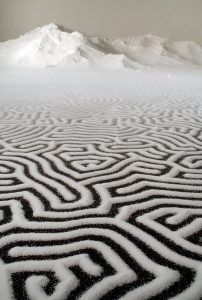
https://www.yatzer.com/return-to-the-sea-motoi-yamamoto
Regarding his work, the artist has said that: ”Drawing a labyrinth with salt is like following a trace of my memory. Memories seem to change and vanish as time goes by; however, what I seek is to capture a frozen moment that cannot be attained through pictures or writings. What I look for at the end of the act of drawing could be a feeling of touching a precious memory …”
If it interests you, here is my interpretation of Anuradha Mathur and Dilip Da Cunha’s digitally constructed maps produced as a reaction to the 2005 floods in Mumbai.
Their work was originally displayed at the national gallery in New Delhi, and therefore i have opted to present their work as an exhibition. In a gallery setting, the artist rarely gives an oral account of their work (perhaps to allow the viewer to construct their own conclusions); however sometimes an artist’s work is supported by audio (often to provide context).
This recording is intended to serve as a jumping off point for a discussion with you: So please have a listen (IMG_1120), or just look (SOAK), and I would love to discuss their work with you after.
Jacopo De Barbari. Woodcut Map of Venice. 1500.
Mapping as memory. Memory as reality. Reality as distortion. Distortion as bias. Bias as truth. Truth as mapping.
SOAK: Mumbai in an Estuary is series of maps by Anuradha Mathur and Dilip Da Cunha . Their digitally constructed representations of Mumbai in and estuary were originally displayed as prints in the national gallery of New Delhi. Their work is a response to the 2005 floods in Mumbai. The way which they chose to record the shoreline is a critique against the type of maps made by proponents of 20th c. flood control measures like the first map I have included in the PDF.
Please take a look and take a look and try to guess the thesis of their work and I will be happy to discuss it with you later 🙂
 Follow