Hello – thank you for visiting my portfolio. I appreciate your interest in my research, professional, and other endeavours.
My academic foundation is in environmental sciences (Bachelor of Science (BSc) from the University of British Columbia (UBC)), with emphasis in ecology and conservation, soil science, and hydrology studies. Below is a summary of my BSc experience:
- Gained practical and theoretical skills in sustainable resource planning and management, remote sensing, and geographic information science (GIS)
- Completed the Science Co-op Program, with placements at ALS Environmental Ltd., Agriculture and Agri-Food Canada (AAFC), and Canadian Natural Resources Ltd. (CNRL)
- During ALS Environmental co-op placement, I gained working knowledge of standard soil carbon testing procedures, including dry combustion and hydrochloric acid leaching
- At AAFC, I performed data collection, including manual field notes, sonar technology, and biomass sampling data, to quantify crop growth and and carbon dioxide flux analyses under variable grazing and environmental conditions
- For CNRL, I systematically reviewed company documents for regulatory compliance and alignment with federal and provincial policies and legislation (e.g., Species at Risk Act, Canadian Environmental Assessment Act (replaced by Impact Assessment Act in 2019), and Alberta’s Water Act, Wetland Policy, and Environmental Protection and Enhancement Act)
- Earned a Minor in Philosophy, focusing on the philosophy of science, logic, and ethics
I earned my MSc from the Integrated Remote Sensing Studio (Faculty of Forestry, UBC), with a thesis project about characterizing multi-decadal vegetative greenness and land use dynamics across Canadian urban areas using satellite remote sensing. I defended my MSc thesis in October 2020 with honours designation, and have since been awarded the Best Master’s Thesis Award from the UBC Faculty of Forestry in 2020 and the National Best Master’s Thesis Award in 2020 from the Canadian Remote Sensing Society. Since earning my MSc, I’ve been involved with additional studies that used the multi-decadal vegetative greenness dataset for urban vegetation exposure studies related to early childhood development and greenspace inequity.
Following my MSc, I’ve been grateful to work with great teams, such as at the Alberta Biodiversity Monitoring Institute (ABMI) and at the elementslab at UBC. Below is a summary of my recent work experience:
- At ABMI, I mapped pothole wetlands across the Canadian Prairies using Sentinel-2 imagery in Google Earth Engine and JavaScript
- With the elementslab, I generated “what-if” tree planting spatial models using ArcGIS and custom R scripts and evaluated potential future effects on greening, shading, indoor and outdoor cooling, and livability of neighbourhoods
- Most recently with the Metro Vancouver Regional District Regional Planning team, I worked on working the comprehensive 2020 Tree Canopy Cover and Impervious Surface GIS dataset, Housing Data Book (2023, 2025), and Projections Portfolio (2025)
Throughout my academic and professional experiences, I’ve developed my technical, research, and project management skills. My skills and professional experiences are detailed in my LinkedIn Profile; a summary is provided below:
- Advanced geospatial and statistical data analysis, including machine learning models, using ArcGIS (Pro and Online), QGIS, custom R scripts, Google Earth Engine + Javascript
- Effective cartography and visualizations, using ArcGIS (Pro, Online, Dashboards, StoryMaps), QGIS, custom R scripts, and Adobe Creative Suite (Illustrator, InDesign)
- Project management, including applied planning and organization strategies, relationship building, effective communication and meeting facilitation, risk management, change control processes, and quality assurance and control (QA/QC)
- Technical writing, including reports, scientific articles, and request for proposals (RFPs)
- Verbal communication, developed by leading project meetings, webinars and workshops, committee and conference presentations, and mentorship
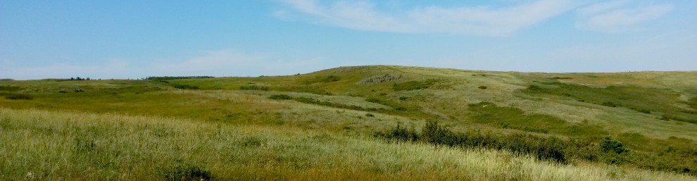
In case you were wondering, the cover photo shown is of Nose Hill Park in Calgary, Canada which I had the pleasure of living near during my first co-op work placement. Nose Hill Park lies within the traditional territories of the Niiitsitapi (Blackfoot Confederacy; Siksika, Piikani, Kainai), Îethka Nakoda (Stoney Nakoda Nations; Chiniki, Bearspaw, Goodstoney), and Tsuut’ina Nation, and is home to Métis people. This land was used by Indigenous peoples for centuries for hunting, spiritual practices, and gathering, as evidenced by archaeological findings and the park’s Medicine Wheel. In the 1980s, this area was designated as a park and remains as one of the largest urban parks in North America. I often would walk the trails and observe the varying plant communities that spanned the area, fascinated by the biological diversity and natural solitude that existed in the middle of a growing metropolitan landscape. Years later, while working with Landsat satellite imagery for my MSc thesis, I was moved to witness how this iconic green space persisted while urban developments continued around and past the park over the course of 30+ years.
Portfolio contents