In this lab, I used a variety of datasets to create a map displaying areas where ski runs could be built. Creating these maps called for layering different datasets, buffering data in multiple ways, and draping my 2D analysis over a 3D hillshade in order to complete my geographic analysis.
Project Memo: Garibaldi at Squamish Ski Hill
Introduction
This report details the results of an environmental impact assessment carried out at the Garibaldi at Squamish ski hill project area. The aim of the assessment was to determine which areas within the project area are to be protected as they are riparian habitats, old growth forest, or ungulate winter ranges. Determining which areas are to be protected will allow for ski runs and other ski hill facilities to be planned while minimizing the environmental impact. The methods used to analyze data, general results, and key environmental concerns are outlined below.
Analyzing Data
Before analyzing the data was possible, it was first necessary to trim all the layers used in this project to the project boundary. This ensures that only data within the project boundary is used in the analysis. After trimming all data layers to the project boundary, the DEM layer was reclassified to give two classes (0-555 m and 555+ m) and then this layer was converted from a raster layer to a vector layer to allow for calculating area. Rivers within the project area were buffered using a variable width buffer. Streams above the snowline (555 m) were given a 50 m buffer as they are less likely to be fish-bearing while streams below the snowline were given a 100 m buffer. The union tool was used to join the river buffer, old growth forest, and ungulate winter range data layers together which then allowed the dissolve tool to be used to create a single polygon encompassing all protected areas within the project area. A map was created showing the protected areas and roads in the project area with a second map showing these elements draped over a 3D hillshade.
General Results
Results of this analysis show that there are 22,100,323 m2 of protected area within the project boundary which amounts to 40.3% of the project area. When summing the individual protected areas, the total protected area is 2,420,107 m2, or 4.5%, larger and this is because there are several areas where multiple protected areas overlap. The area below the snowline (555 m) is 16,371,095 m which is 29.99% of the total project area.
Environmental Concerns
The two greatest environmental concerns to project development are that many of the existing roads cross rivers or the river buffers which poses a threat to riparian habitats and nearly one-third of the project area is below the snowline and this will increase in the future due to climate change. To mitigate the hazards posed to riparian habitats, limiting the use of roads below the snowline and using roads that cross the least amount of riparian areas above the snowline is recommended. To mitigate the effects of a rising snowline, snow making machines will need to be used by the ski hill with more frequency. Given that the project area borders a provincial park which limits the project area’s expansion, there is little the ski hill would be able to do other than creating snow artificially.
Conclusion
The protected area within the project area is 40.3% while 29.99% of the project area is below the snowline of 555 m. Because so much of the project area is either in protected areas, below the snowline, or both, the available area for project development is limited. Within the protected area, there is 16,494,941 m2 of riparian habitat which intersects with nearly all existing roads making the risk of harming these habitats high. Due to climate change, the snowline is expected to rise which will increase the area in which skiing is not possible. The large amount of protected areas and area below the snowline are significant challenges project developers will need to manage to develop a functional ski hill.
[Click on any map to enlarge]
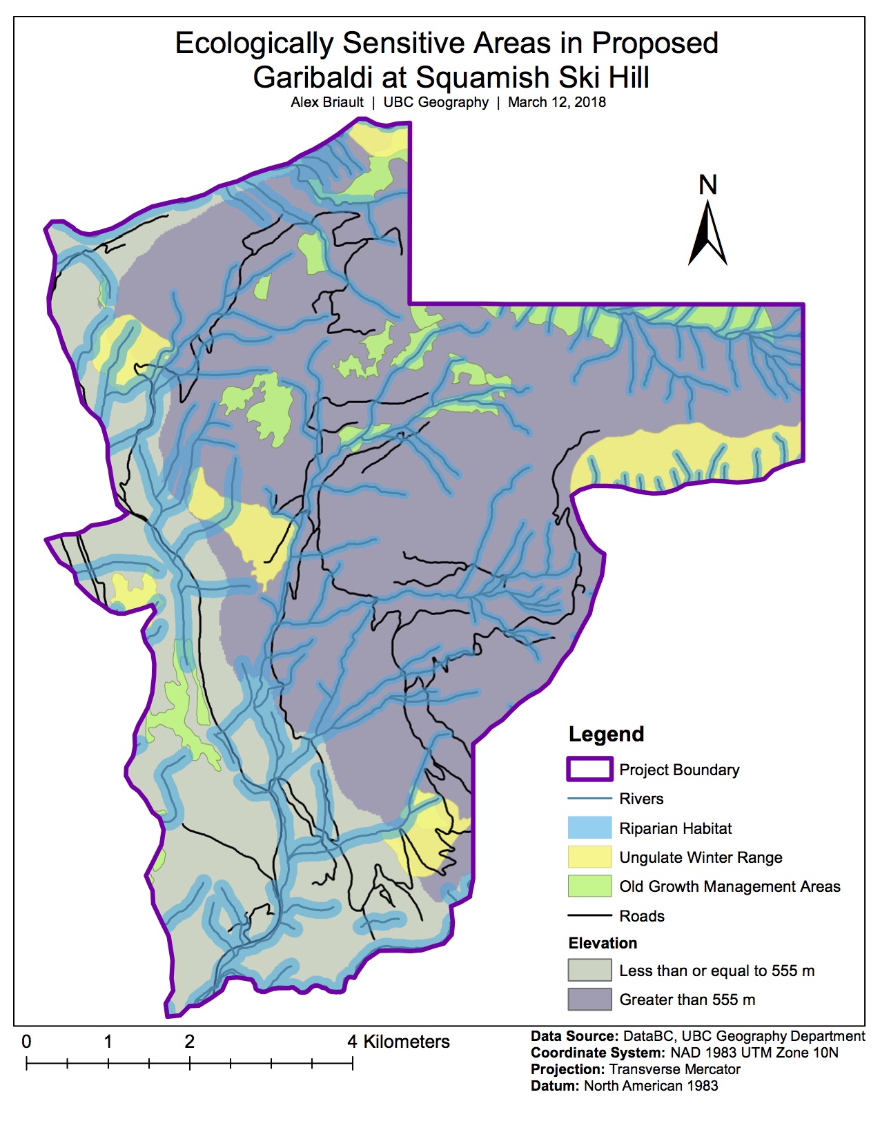
Map 1: Ecologically Sensitive Areas in Proposed Garibaldi at Squamish Ski Hill
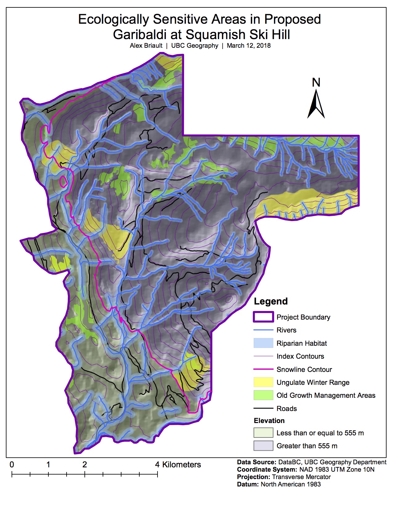
Map 2: Ecologically Sensitive Areas in Proposed Garibaldi at Squamish Ski Hill with Hillshade