Northland Properties and Aquilini Investment Group of Vancouver have been attempting to obtain permission to build Garibaldi at Squamish Ski Resort since 1997. Over the last 18 years, they have submitted environmental assessment reports in the hope that their application would be approved and building work could commence. However, the BC Environmental Assessment Office did not consider their environmental impact assessment adequate in ensuring wildlife, vegetation and fish would be unharmed. Furthermore, it was noted that much of the proposed area is below 555m, which will not receive enough snow during the ski season and therefore the area is not economically viable for a ski resort. Through an environmental impact assessment produced using Arc GIS software, I will address these criticisms, recommend which is the most important issue to overcome and which ones are relatively minor.
The first step involved in creating an environmental impact assessment using GIS software is to obtain appropriate data. For data relating to the proposed ski resort, I downloaded Ungulate winter range data and data showing old growth management areas from DataBC, an open source data website. When downloading this data, I ensured that each file was using the same projection and thus will be accurately displayed on a map. Furthermore, I used data which had been obtained, parsed and filtered by the UBC Geography department. This included shapefiles for the project boundary and terrestrial ecosystem mapping, TRIM files on roads, rivers, contours, parks and data for protected area boundary and a digital elevation model.
The data obtained from DataBC contains more information than is required for this environmental impact assessment, so the first analysis step was to clip the data sets for ungulate winter range and old growth management areas. By clipping data, this means that only data within the project boundary will be shown on the map.
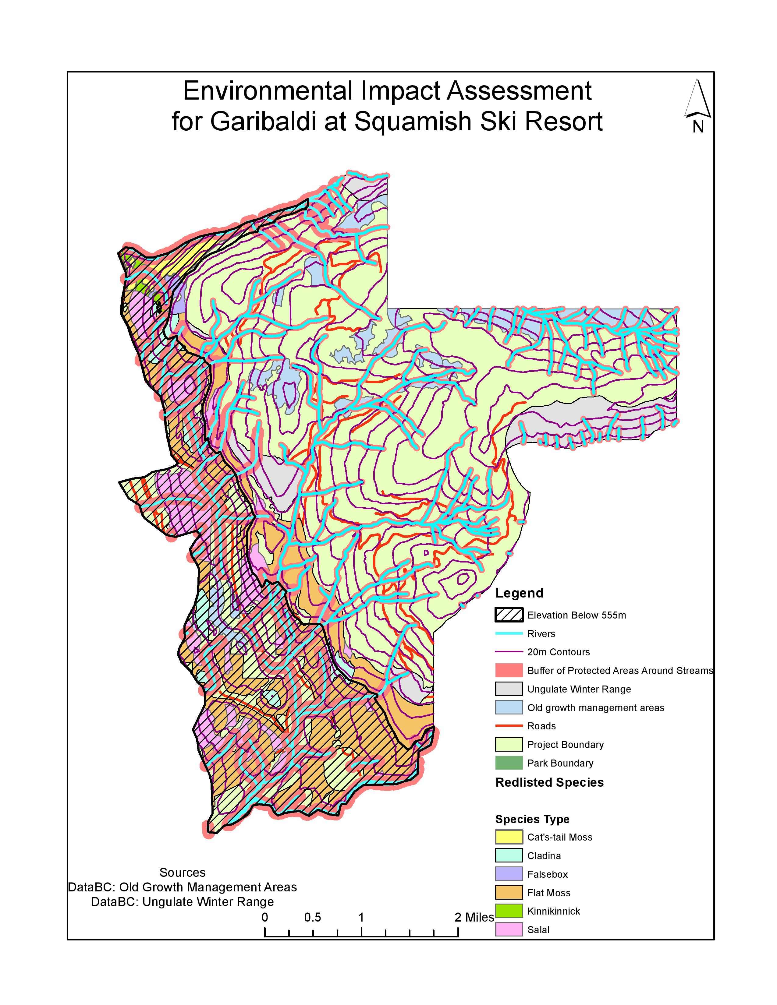
One of the most concerning criticisms of this location for a ski resort is how much area is below 555m, as areas below this altitude do not receive enough snow for a ski resort. In order to show which areas are below this altitude, I divided the data into areas above and below 555m by reclassifying the data using equal intervals. By converting this raster layer to a polygon, I was able to see how much area of the map is below 555m. Within the proposed project area, which is 54717275m2, 16371199m2 is below 555m, which is 29.9% of the total project area. This area is represented as black hash lines on the map.
When the first application to build this ski resort was submitted, the environmental impact assessment was rejected because it did not appropriately consider the impact on wildlife. Data provided by DataBC contains information on the winter habitat of Mule Deer and Mountain Goat. By looking at the attribute table for this layer, I can see areas of ungulate habitat in meters squared and display these areas on the map on top of the proposed project layer. The total of these areas is 4315158.9m2. As a percentage of the proposed project area, 7.87% of the ski resort would be within ungulate winter habitat. Along with ungulate habitat areas, it must be considered if endangered or threatened ecosystems are located in the proposed project boundary. To do this, I viewed the attribute table of the terrestrial ecosystem mapping layer and selected each species by their site series and biogeoclimatic unit. I then combined all of these areas to make a total area for each endangered species. I repeated this process of selection and merging for six endangered species and created a new layer on the map for this data called ‘red listed species.’ To calculate what percent of the proposed project site would be in red listed ecosystem areas, I found the sum of all of the areas of red listed species, 13584529.95m2, and divided this by the total proposed project area 54717275.03m2, which is 24.83%.
To display how much of the proposed project area falls within areas with rivers and streams and therefore the potential for damage to fish ecosystems I used a variable width buffer on the rivers layer. Rivers above 555m are less likely to contain fish so are therefore given a buffer of 50 meters, and rivers below 555m are more likely to be fish bearing so are given a buffer distance of 100 meters. This means that when constructing a ski resort, the developers must avoid building within these buffer zones around streams. The total buffer area is 16488854m2, which means that 30.1% of the proposed project area will fall within fish bearing streams.
The combined percentage of the total project area that will directly impact old growth forest, ungulate habitat, red-listed ecosystems and fish is 69.58%. Along with the 29.9% of the area which is below 555m so will not receive enough snow, there are some concerns of how much of the land could be used effectively and sustainably without mitigating some of the problems.
The greatest environmental concern is the large area which is below 555m and is not likely to receive enough snow each year to sustain a ski resort and make the project economically viable. Instead of considering this land as wasted investment, other areas of the resort could be located here, such as shopping outlets and restaurants. These are amenities which are not dependent on snow, and having an area which is separate from the skiing area could attract more non-skiing visitors to the resort. However, another environmental concern is the large amount of the proposed project area which falls within fish bearing streams. This is a huge environmental concern as building a ski resort in this location will destroy many fish habitats. Mitigating this issue is problematic and is likely to be a financial burden on the project. One potential mitigation in low lying areas where the buffer distance is 100 meters would be to build shops and restaurants around the rivers and incorporate them into the resort. However, at higher altitudes where the ski runs will be built, it is much harder to include the rivers in the landscape alongside the ski routes, therefore if the ski resort were to be built at this location it would have a highly detrimental effect on fish populations. If this project were to go ahead, I would suggest that the majority of construction took place in the areas above 555m, as this area has a less dense population of red listed species and the environmental degradation would be more limited.
When working as an environmental consultant, you work with the most reliable and non-bias data you can obtain in order to create a trustworthy and informative environmental impact assessment for the project you have been assigned. However, consultants can often be involved in projects that they do not ethically believe in, which can make producing a non-bias assessment difficult when the person producing the assessment disagrees with the mitigations of problems they are suggesting. Personally, I do not think the Garibaldi at Squamish ski resort should be constructed. This is due to the extensive detrimental effect on wildlife ecosystems that this project would have. Although in the memo above I suggested that the area below 555m could be used for non-skiing activities as they would not receive enough snow, I do not think there should be any construction on this land. This is due to the large area in which red listed species inhabit in this location and the likelihood of fish populating streams in this area is high. The 100m buffer in this location covers a large area, making it very difficult during construction to avoid damaging streams and depleting fish populations. Furthermore, a large portion of this area is covered with flat moss which would have to be removed in order to build the ski resort here. As an environmental consultant on this project, I would need to mitigate this problem, however I believe that there is no viable solution or justification for destroying land which contains red listed ecosystems.
In conclusion, although there is steep land in the area of the map above 555m, this land is broken up with rivers and their buffer zones, ungulates and old growth forests which will be vulnerable to damage if construction of the ski resort is given permission for this area.
