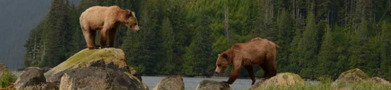
The Kootenay region in southeast British Columbia encompasses pristine mountain ranges and rugged valleys, as well as a Grizzly bear (Ursus arctos) habitat corridor that connects Northern Montana to the Yukon and Northwest Territories. What once used to be the heart of their habitat now lies along a fragmented edge, predominantly due to the impact of roads.
The majority of roads in the Kootenays are resource and service roads, which do not disappear and will therefore only increase in density over time. This fragments their core habitat that must have an area of 10km2 to be sufficient for a mother and her cubs. Roads divide habitat area and populations, disturb Grizzly bear behaviors (Boulanger & Stenhouse, 2014) and allow greater public access into more remote areas, where bears are more likely to be found. This increases the risk of illegal hunting which is harder to detect in remote regions, and recreational road use that can result in recurring human interactions with animal control related mortality as a consequence.
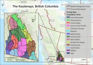
A survival analysis found that most Grizzly bear deaths occur within 500m of a road, whether that be paved or a secondary resource road (Boulanger & Stenhouse, 2014). This was confirmed by the Stewardship Baseline Objectives Tool (SBOT) of BC which further categorized road densities into 7 classes. Bear habitats are divided into spatial Grizzly Bear Population Units (GBPU), of which there are 55 in BC and 14 in the Kootenays (Environmental Reporting BC, 2020), that consider bear ecology and management areas which reflect population stability. These are further divided into Wildlife Management Units (MWU), representing bear densities.
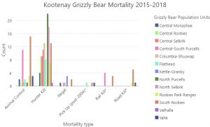
Until December 2017, hunting Grizzly Bears was legal in British Columbia which made up a significant portion of their mortalities. Although infrequent, illegal hunting still continues but animal control related mortalities persist in areas with increased human activities. Pick Up (post-2004) refers to undistinguished road and rail kill.
This report analyzes the spatial relationship between Grizzly bear populations and road densities between 2015-2018 in the Kootenays, and further explores the current impact (2022) roads have on core habitat.