LiDAR
There are various types of remote sensing technologies that exist to help geographers and earth scientists understand and answer geospatial queries. Remotely sensed imagery has helped predict weather, guide conservation efforts, help natural resource locating and so much more. Light Ranging and Detection (LiDAR) falls under the ‘active’ category of remote sensing and offers a new level of accuracy when it comes to terrestrial models.
LiDAR uses laser return times and wavelengths to produce digital 3-D representations of the target. In a LiDAR system, light is emitted from a rapidly firing laser. You can imagine light quickly strobing from a laser light source. This light travels to the ground and reflects off of things like buildings and tree branches. The reflected light energy then returns to the LiDAR sensor where it is recorded. A LiDAR system measures the time it takes for emitted light to travel to the ground and back. That time is used to calculate distance traveled. Distance traveled is then converted to elevation. These measurements are made using the key components of a LiDAR system including a GPS that identifies the X,Y,Z location of the light energy and an Internal Measurement Unit (IMU) that provides the orientation of the plane in the sky.
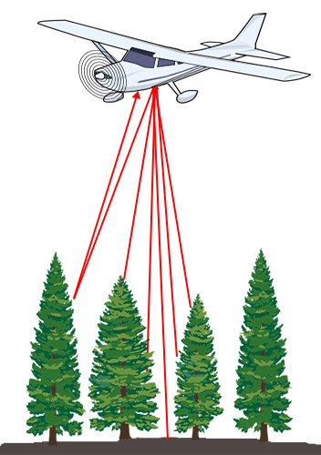
How aerial LiDAR data is extracted using lasers.
How Light Energy Is Used to Measure Trees
Light energy is a collection of photons. As photon that make up light moves towards the ground, they hit objects such as branches on a tree. Some of the light reflects off of those objects and returns to the sensor. If the object is small, and there are gaps surrounding it that allow light to pass through, some light continues down towards the ground. Because some photons reflect off of things like branches but others continue down towards the ground, multiple reflections may be recorded from one pulse of light.
The distribution of energy that returns to the sensor creates what we call a waveform. The amount of energy that returned to the LiDAR sensor is known as “intensity”. The areas where more photons or more light energy returns to the sensor create peaks in the distribution of energy. Theses peaks in the waveform often represent objects on the ground like – a branch, a group of leaves or a building.
LiDAR data have also been used to derive information about vegetation structure including:
- Canopy Height
- Canopy Cover
- Leaf Area Index
- Vertical Forest Structure
- Species identification (if a less dense forests with high point density LiDAR)
My research will use LiDAR to create realistic models of the fuel load of the forest in the Okanagan Valley, allowing more accurate predictions to be made than ever before.