Applications & Recommendations:
In Surrey, the most significant limitation against increased agricultural production is the lack of available water resources. The water chain and suitability assessment revealed that the current agricultural supply (the river system) would be unlikely to be able to support any additional water extractions. However, it also revealed that alternative water resources exist, and may provide the opportunity for increased agricultural production. By applying this information from the water chain assessment into the holistic decision-making framework, it is possible to imagine what new forms small-scale agricultural production could be developed in Surrey. The following exercise aims to provide examples and recommendations for how the framework and the water assessment could be effectively put into practice, from the individual farm scale to the regional scale, in order to improve the functioning of the water system in Surrey.
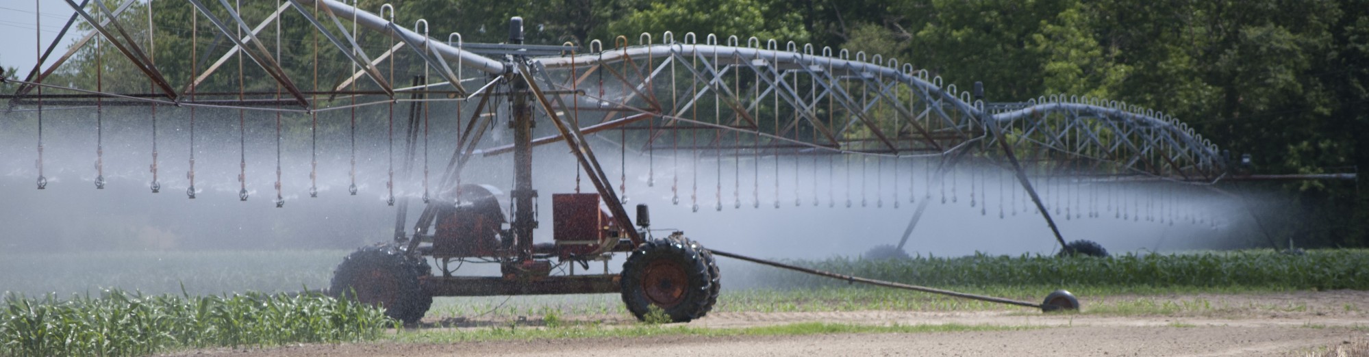
Rainwater Harvesting: Individual Farm Scale
The first application will focus on the use rainwater harvesting on a small plot in the eastern sector of Surrey’s ALR. The use of the decision-making framework will be enacted from the perspective of an individual farmer.
- Define the whole:
The plot of land is approximately 16 ha in size, and is located on the northern boundary of the eastern arm of Surrey’s ALR. It borders on a steep forested ridge; above which is residential development. The property itself has an undulating to gently undulating topography. Approximately 2 ha of the property are forested. The soils in this region are predominately orthic gleysols of the Kitter Series, developed on medium-textured deltaic deposits; although Embree and Goudy series soils are present as well. [1] These soil series are characterized by a medium to fine texture, poor to moderately poor drainage, and high water tables.[2] The soil is considered well-suited for crops that can withstand wet conditions and shallow water tables, and not well-suited for crops that do not withstand high amounts of moisture.[3]
Well-suited crops include:
- Annual legumes
- Blueberries
- Cole crops
- Corn
- Perennial forage
- Rooted crops
- Shallow rooted annual vegetables
Unsuited crops include:
- Nursery and Christmas trees
- Tree fruits
- Carrots
- Celery
- Raspberries
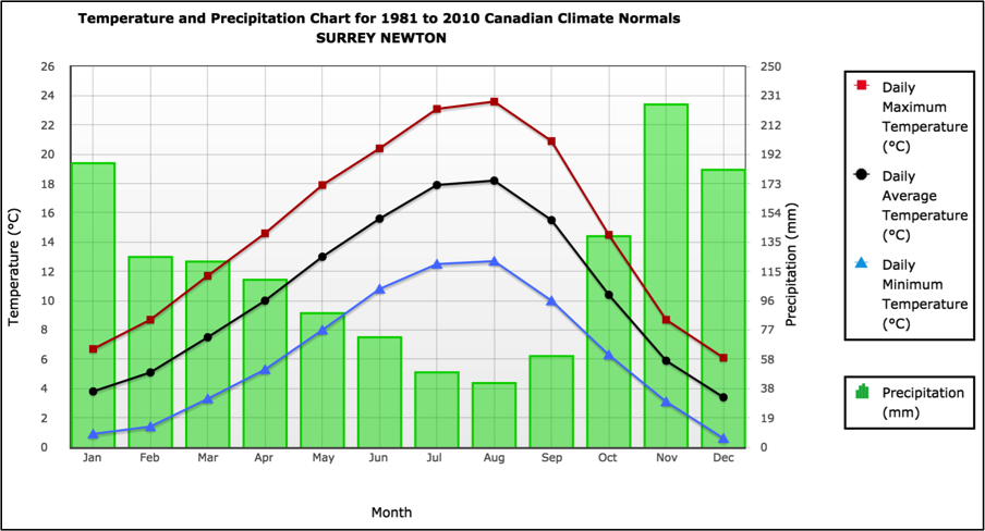
Surrey receives approximately 1400 mm of precipitation annually. Over half of that amount falls during the winter months, from October to January, while the growing season is characterized by low rainfall and frequent periods of drought. Consequently, relying solely on summer rainfall for agricultural water is unreliable, and may result in crop failure in dry years.
The greatest constraints to the agricultural productivity of this site are its size and the need for water management. The soil is poorly draining and crop production is limited by high water tables and excessive moisture. Concurrently, water licenses for river water are not available; therefore alternative sources of irrigation water must be found.
- Set goals.
Agricultural decisions are highly personal and will vary greatly depending on the unique context, preferences, and values of individuals; however, the basic components of a goal for an individual in this situation may be:
“To regulate the water management of the farm, in a way that protects its overall environmental value and sustains the ability of the water and soil resources to renew themselves over the long-term, for the purpose of generating agricultural production and a viable livelihood.”
- Develop management processes.
In order to achieve the goal, the management processes should aim to address the major constraints that were identified in step one. On any farm, production has an upper limit based simply on the size of the available land. Therefore, in order to support the livelihood of the farmer, small plots of land such as this one should aim to maximize the density and value of the crops produced. Certain high-value specialty crops, for example field vegetables like kale, are currently experiencing a surge in demand. Because of the peri-urban environment of the farm, it is in close proximity to a variety of local produce market opportunities, including farmers markets, grocery stores, and restaurants. An assessment of these markets should be conducted in order to determine which crop would be the best choice for this farm. Furthermore, the peri-urban environment provides unique opportunities to use agro-tourism as an additional source of income for farms. Farms that bring paying Surrey citizens to the farm, for example through u-pick operations or seasonal attractions like corn mazes, can bring in extra income and increase the diversity of their operations.
The farm plan should aim to address the soil water conditions, as this will increase the number of crops that will be able to grow, and will increase the productivity of the crops. Rainfall is a promising alternative water source for irrigation water; however it is limited by the temporality of its availability. In order to overcome this, it is necessary to capture and store the rainwater from the winter for use in the summer months. This farm has a high potential for harvesting stormwater due to its location and topography. Because the northern portion of the farm borders on a steep slope, it provides a natural avenue for capturing surface runoff from the slope and thus increasing the amount of rainwater captured. At the base of the slope, a storage area can be constructed, and the extracted soil can be applied on the farm’s fields and formed with a gentle slope toward the collection pond. In this way, the raising and the shaping of the fields will improve their drainage capability, as well as direct excess water toward the collection pond. Artificial drainage may still be required if conditions are still wetter than optimal.
Furthermore, the farmer should aim to use conservation crop, irrigation, and soil management practices. These practices should aim to increase the water-holding capacity of the soil, and minimize the amount of contamination in the farm drainage. Irrigation practices should use the most efficient application methods possible for the chosen crop, and should follow calculated application timing and quantity methodologies.
- Monitor, assess, adapt, and repeat.
It will be critical to monitor water quality and soil moisture regularly in order to ensure that the water is free from contamination and the soil conditions are optimal for crop growth. Management practices should be adapted regularly according to the results of the monitoring, and the achievement of all components of the holistic goals should be regularly examined.
Groundwater Harvesting: Multi-Farm Scale
The second application will focus on the use of groundwater harvesting on a series of small plots in the northern sector of Surrey’s ALR. This example is using a cooperative farming model to demonstrate the potential of using the water chain assessment and decision-making framework over a larger area that includes multiple independent farmers. Cooperative farming allows land, capital, knowledge, labour, resources, and infrastructure to be shared among many farmers. In situations where resources are scarce, (or unavailable, as water licenses are in Surrey), cooperative models can increase the efficiency of water use and increase the viability of using alternative water resources.
- Define the whole:
The size of this parcel of land is 30 ha in total, and it is made up of 8 individual lots that range from 3-5 ha in size. Most of the soils in this parcel are included in the Lumbum soil management group, and include the soil Gibson, Lumbum, and Banford soil series. These soils are characterized by a layer of partially to well decomposed organic material overlaying fine-textured mineral deposits.[4] They have very poor drainage, high water tables, and high water and nutrient holding capacity. Without drainage there are no crops that are well suited to these soils; however with drainage, there is increased risk of subsistence decomposition of organic matter.[5] With drainage the suitable crops include:
- Annual legumes
- Blueberries
- Cereals
- Cole crops
- Corn
- Perennial forage crops
- Root crops
- Shallow-rooted annual vegetables
Even with drainage improvements, the following crops are considered unsuitable for this soil due to excessive amounts of moisture:
- Nursery and Christmas trees
- Raspberries
- Strawberries
- Tree fruits
Although water licenses are unavailable for agriculture, this site has a high potential to use groundwater for irrigation. The site is situated above the boundary between the Nicomekl-Serpentine and Newton Uplands aquifers. The Nicomekl-Serpentine aquifer is known to have some quality concerns that may limit the suitability of certain types of agricultural production; however the composition of the water is variable across the span of the aquifer. In the lowest quality areas of the aquifer, situated in the main Nicomekl-Serpentine River valley between the two rivers, high levels of chlorides, sulfates, sodium, and total dissolved solids make the water highly unsuitable for any form of agricultural use.[6] Closer to the boundaries of the aquifer near the upland areas of Surrey, sporadic testing has revealed that the water quality generally improves to a “suitable to excellent” classification for agriculture.[7] [8] Because the study site is located close to the aquifer border, it is likely that the water would be suitable for agriculture, although this requires confirmation through additional water testing.
Also included in this cooperative farming system are the individual farmers who own and share the land, resources, knowledge, and capital.
Unlike the above example, the size of the plots is a less serious constraint against production – this is because under the unified cooperative model, the many small fields are able to function as one large field. As a result, a wider variety of crops may be suitable for this site. The greatest constraints to agricultural productivity on this site are its need for water management and the lack of available water licenses for irrigation. The soil is poorly draining and crop production is limited by high water tables and excessive moisture. Concurrently, water licenses for river water are not available; therefore alternative sources of irrigation water must be found. Groundwater may be a suitable option for supporting agricultural production; however the state of its water quality may limit the suitability for certain crops.
- Set goals.
Similar to the first example, a goal for this farming system will be influenced by the values and interests of the farmers; however it will likely include the following elements:
“To regulate the water management of the farm, in a way that protects its overall environmental value and sustains the ability of the water and soil resources to renew themselves over the long-term, for the purpose of equitably generating agricultural production and a viable livelihood for all the individuals involved in the cooperative.”
- Develop management processes.
In order to overcome the constraints that the soil and water supplies impose on the system, the management processes should focus on improving drainage, lowering the soil water table, securing a source of irrigation water, and maximizing the productivity of the low quality water supplies. The use of controlled drainage and subirrigation may offer an opportunity for this site to achieve all of these outcomes at the same time.
Controlled drainage and subirrigation is a practice that allows for very precise control of water table levels. The infrastructure is very similar to that of subsurface drainage tiles, in which soil water is channeled into tubes. However, instead of draining freely out of the system, controlled drainage/subirrigation channels have devices that can control whether soil water is retained or released from the system. In this way, in dry periods the system can retain soil water for plant uptake and in wet times in can release excess water out of the soil. Furthermore, studies have indicated that this process can reduce the harmful effects that low quality and saline water can have on crops.[9]
On this site, the use of controlled drainage and subirrigation would also allow the farmers to maximize the productivity of potentially low quality groundwater available to them. In order to maintain the long-term productivity of the soil, the fields should be flushed with fresh, high quality water on periodic basis if the water is of low quality.[10] However, since flushing is only required periodically, the requirement for fresh water is minimized, and the supply can be shared and rotated among all the farmers in the cooperative. In the winter when the fields are not in production, the water table can be raised in order to minimize the decomposition of the organic material in the fields. Annual crops will be most suitable for these conditions, and may include annual field vegetables, root crops, and corn.
As with the previous example, this plot of land has access to a variety of urban markets, and should assess these markets for demand. Priority should be given to cropping systems that may also provide revenue from agro-tourism. These may include crops such as corn and pumpkins, which can be incorporated into season tourist attractions such as corn mazes and pumpkin patches.
- Monitor, assess, adapt, and repeat.
It will be critical to monitor water quality, soil moisture, and soil conditions regularly. This will ensure that the water is maintained at an acceptable quality for agriculture; that the soil moisture is at an optimal level for both plant growth and the prevention of decomposition; and that the soil is not being degraded through the build-up of salts or metals.
Management practices should be adapted regularly according to the results of the monitoring, and the achievement of all components of the holistic goals should be regularly examined.
City Water System Functioning: Regional Scale
The third application will focus on the overall functioning of the city water system, as was the focus of the water chain assessment in the previous section. The decision-making framework will be assessed from the perspective of a municipal water manager.
- Define the whole.
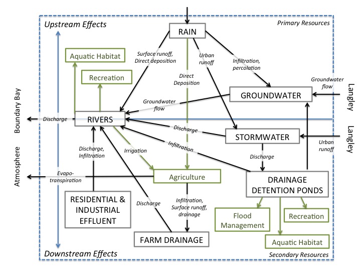
As the chart above summarizes and the water chain analysis discusses in the previous sections, the Surrey water system is a complex network of many components. Surrey residents, farmers, tourists, and wildlife are all users of the system. At this time, the use of rivers is regulated under the jurisdiction of the provincial government, and certain groundwater resources are shared with the City and Township of Langley; however, the city of Surrey has legal jurisdiction over the remainder of the resources. The major constraints on the system include the lack of any additional available water supply from the river systems; the poor water quality and damaged water quality in the river systems; and the excess of water in the lowland areas.
- Set goals.
Surrey’s water system has several functions; however none of the functions are currently unified under one holistic goal. As a result, certain functions are being achieved at the cost of damaging another function; certain resources are being heavily extracted while others are not being used at all; and there is little integration among regulation and management of individual resources. Through the creation of a unified goal, the city would be able to unite all the goals in the water system and increase the efficiency of how all its resources are used to meet to those goals. Surrey’s holistic goal should include the following elements: “To increase the efficiency of water use and productivity within Surrey’s water system, in a way that protects the ability of the water resources to renew themselves over the long-term, for the purpose of supporting agricultural production, flood management, aquatic and wildlife habitat, and recreational opportunities for Surrey’s citizens, both now and in the long-term.”
- Design management processes.
Surrey’s water system is complex, and the problems that the city is facing at this time are largely the result of disjointed water resource management systems. In order to unite the system towards a common goal, and address and possibly ease the constraints that are limiting productivity; the city should focus its management efforts towards several important processes.
The water chain assessment revealed that the effects of urbanization and high levels of development were causing measurable and significant harm to certain of Surrey’s water resources. Namely, stormwater runoff and residential and industrial effluent are introducing contaminants into the 3 river systems, and as a result, agricultural productivity, recreation and wildlife habitat are suffering. Surrey is dually urban and rural, and the connectivity of resources between these two facets of the city is inextricable. In order to preserve this dual nature and encourage future urban and rural development at the same time, it is imperative that the city begins to integrate these interests in regulatory systems and infrastructure development. For example, stormwater channels and drainage detention ponds are created for the purpose of remediating the effects of urban development, preventing flooding, and reducing water contamination. In an integrated water management system these resources would not be considered waste, and the needs of other functions would be considered within their management. In an integrated system, these resources could be diverted and treated not merely to prevent flooding, but rather to reintroduce them as a valuable resource into the system for the purpose of achieving another function, such as agricultural production.
Furthermore, the water chain assessment can be used to identify critical control points within the water system. These are points within the functioning of the water system where the quality or quality of the water resources decreases significantly. By understanding where these points exist and what processes cause them, it is possible to target preventative or remediating action. In Surrey, these critical control points are located where surface runoff of urban and agricultural stormwater, agricultural drainage, and residential and industrial effluent discharge into the river systems. The capture and storage of stormwater in detention ponds are a critical control point at which potential productivity is lost. The city of Surrey should develop plans to actively mitigate pollution and increase productivity at each of these points through initiatives such as water treatment facilities, implementation of agricultural best management practices, or increased regulation of industrial discharge.
However, before any of this can be achieved, there is an immediate need for increased monitoring and study of Surrey’s water system. At this time, only the river systems are monitored for water quality and quantity, and even this is sporadic and disjointed among several different interest groups. Groundwater is not monitored at all and thus the quality, quantity, and hydrology of Surrey’s aquifers is still largely unknown. In order to increase the efficiency of the water system and guide the sustainable extraction of new water resources, it is first necessary to gain a more complete understanding how they are connected, and how development and extractions affect them.
- Monitor, assess, adapt, and repeat.
As development changes and increases in Surrey so to will the context for water management. Constant monitoring, assessments, and adaptations will be necessary in order for the system to remain resilient for the long-term.
Although these assessments have focused on 3 specific combinations of management processes, resources, and scale, this is by no means an exhaustive or exclusive list of the ways in which the water system can be managed in Surrey. It is entirely feasible that a group of farmers could cooperate to remediate, protect, and use agricultural drainage as a water supply; or that an individual farmer could use drainage detention ponds to irrigate his fields. Rather, the aim of this exercise was to demonstrate the process by which such decisions can be made and outcomes can be produced.
Works Cited:
[1] Savory, A. (1999). Holistic Management: a New Framework for Decision-Making. Washington D.C., United States: Island Press.
[2] Sullivan, P. (2001). Holistic Management a Whole-Farm Decision Making Framework. ATTRA Sustainable Agriculture Information Centre Fact Sheet. Retrieved from https://attra.ncat.org/attra-pub/summaries/summary.php?pub=296
[1] Luttmerding, H. (1981). Soils of the Langley-Vancouver Map Area. BC Ministry of the Environment, Assessment and Planning Division. BC Ministry of Environment.
[2] Luttmerding, H. (1981).
[3] Bertrand, R., Hughes-Games, G., & Nikkel, D. (1991). Soil Management Handbook for the Lower Fraser Valley (2nd ed.). Abbotsford, BC, Canada: BC Ministry of Agriculture, Fisheries and Food.
[4] Luttmerding, H. (1981).
[5] Bertrand, R., et al. (1991).
[6] Halstead, E. (1978). Nicomekl-Serpentine Basin Study, British Columbia. Fisheries and Environment Canada: Inland Waters Directorate, Pacific and Yukon Region, Water Resources Branch. Vancouver: Fisheries and Environment Canada.
[7] Halstead, E. (1978).
[8] Golder Associates. (2005). Report on Nicomekl – Serpentine Water Supply and Quality Assessment. Abbotsford.
[9] Gowing, J. W., Rose, D. A., & Ghamarnia, H. (2009). The effect of salinity on water productivity of wheat under deficit irrigation above shallow groundwater. Agricultural Water Management, 96(3), 517–524. http://doi.org/10.1016/j.agwat.2008.09.024
[10] Qadir, M., Sharma, B. R., Bruggeman, a., Choukr-Allah, R., & Karajeh, F. (2007). Non-conventional water resources and opportunities for water augmentation to achieve food security in water scarce countries. Agricultural Water Management, 87(1), 2–22. http://doi.org/10.1016/j.agwat.2006.03.018