The case studies were conducted in the city of Surrey, British Columbia, Canada. Surrey, a part of the Metro Vancouver region of BC, is a city of dual urban and rural characteristics. In an area of just over 300 km2, Surrey provides home to nearly 400,000 thousand people as well as supports a thriving and productive agricultural industry. The city is rich in the natural resources that have made it so fertile to both human and agricultural life; however as the pressure for growth continues both anthropogenically and agriculturally, the city’s resources are becoming faced with increasing and competing demands and effects. In order to accommodate growth and ensure that productivity continues in both these sectors, Surrey is faced with the challenge of improving how it manages its finite land and water resources.
Surrey is an example of a global trend. As rapidly urbanizing communities located in a favourable, livable geographic region with fertile soils and a moderate climate, cities like Surrey, Los Angeles, and London are extremely fertile for both urban and agricultural development. These cities, and many others around the world, have been built upon agrarian roots
Surrey is the second most populated city in British Columbia, and the 12th most populated city in Canada. Zoom in and click on the map to see Surrey’s 6 communities (Whalley, Guildford, Newton, Fleetwood, Cloverdale, and South Surrey) and agricultural areas (Agricultural Land Reserve).
Demographics:
Surrey is home to a large and diverse population. In the past decade alone, Surrey has welcomed over 100,000 new residents – a trend which is predicted to continue over the next 3 decades, resulting in a possible 300,000 additional residents by the year 2046 [1], for a population of over 800,000 people. As such, Surrey is one of the fastest growing cities in the country. In the past decade, the majority of the population growth and development have occurred in the communities of South Surrey, Cloverdale, and Newton, with a total of just over 11,000 new residential lots [2] being created, along with other industrial and commercial development. Of these residents, high proportions are immigrants, with over 40% of Surrey residents reporting English as their second language [3]. The three most common occupational categories [4] are sales and service; trade, transport, and equipment operators; and business, finance and administration. Income and relative affluence vary widely [5] among the communities, with South Surrey earning nearly two times the average income of Whalley.
Biogeoclimatic Characteristics:
Climate:
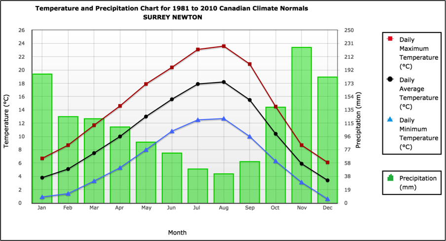
Surrey is located in an oceanic climate zone, and therefore experiences temperate temperatures throughout the year, with warm dry summers and mild wet winters [6]. The average annual temperature is 10.5°C, with the winter average reaching about 5°C and the summer average reaching about 17°C. The average annual precipitation reaches approximately 1400 mm, with over two thirds of the precipitation occurring in the non-growing season, and over half of that precipitation occurring from October to January (figure 1) [7].
As a result of its temperate climate and long growing season, Surrey experiences between 1,600-1,800+ growing degree-days each year, making it of the highest climate capability class for agriculture in Canada. However, due to the frequent dry spells and relative lack of precipitation during the growing season, the region is prone to experiencing water deficits [9].
Landscape:
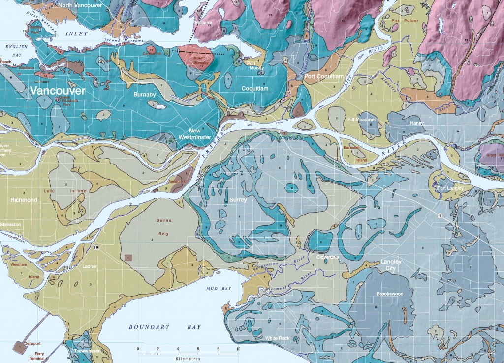
Surrey’s landscape is dominated by distinct uplands and lowlands. Surrey is located within the Fraser Valley Lowland – a triangular region surrounding the Lower Fraser River that extends from the municipality of Hope in the east, and widens toward Vancouver, the American border and the mouth of the Fraser River. Surrey has a landscape that is typical of the Fraser Valley Lowland region, characterized by wide flat uplands and low flat valleys. Surrey’s two main river valleys, the Nicomekl-Serpentine Basin and the Little Campbell Basin, range in elevation from few metres below sea level to about 5m above sea level. Extensive dyking and drainage infrastructure has been installed in these low-lying areas in order to prevent the tidal inundation that once occurred at every high tide [10]. Of these two basins, the Nicomekl-Serpentine is the largest, at 322 km2 [11]. The Newton Upland, Clayton Upland (Cloverdale), White Rock Upland, and Langley Uplands surround the river valleys, and climb to about 130-150m in elevation at their maximum [12].
Soil, Geology, and the Movement of Water:
In general, water flows from Surrey’s uplands to lowlands; and the surface material in these upland areas directly influences the quality and quantity of water that moves into the lowlands. The Newton Upland has a undulating, hilly surface that is underlain by relatively impervious stony marine clays, till, and till-like mixtures which result in high amounts of runoff following rain events [13]. Similarly, the Langley Upland and Clayton Upland have areas of stony marine clays that contribute to high runoff rates, while parts of the Langley Uplands are underlain by sand and gravel, and thus there some precipitation flows into the unconfined Langley aquifer [14]. Furthermore, the highly developed uplands have large amounts of impervious areas due to the high density of buildings and paved surfaces, and as a result as development increases, increasing rate of streamflow and runoff are noted at areas downstream [15].
The lowlands are primarily underlain by fluvial (deltaic) parent materials and the Goudy, Nicomekl, Richmond and Embree soil series. These soils are characterized by their poor drainage capabilities, high water holding capacities, high water tables, and saline subsoils [16]; and as a result, much of Surrey’s agricultural area deals with excess amounts of water.
Land Use:
The difference in the general land use between the upland and lowlands is distinct. In general, the uplands areas are heavily urbanized under residential, commercial, and industrial development, while the lowlands are primarily dedicated to low-density agricultural production. In fact, nearly all of the Agricultural Land Reserve area in Surrey is present in the low-elevation floodplains.
Agriculture:
Surrey has a rich agricultural land base which supports large and productive agricultural industry. Approximately one third of Surrey’s land area is situated within the Agricultural Land Reserve (ALR) of British Columbia. The Agricultural Land Reserve is a collection of the most productive agricultural land in British Columbia, in which agricultural production is prioritized and other forms of development or land use are severely restricted. As a result, in Surrey, residential, commercial, or industrial development on agricultural on ALR is highly regulated and any land taken out of the ALR zoning must be replaced by a parcel of land twice the size and of equal agricultural capability being introduced into the ALR in exchange. ALR land covers 9,209 ha (92.9 km2) in Surrey and is used primarily for the production of forage and pasture (25% of Surrey’s ALR land area), berries (15%) and field and salad vegetables (6%), as well as for poultry and dairy production [17] [18]. Although only 1.3% of Surrey’s population is employed in the agricultural industry [19], Surrey’s agricultural lands are some of the most productive in Metro Vancouver, and indeed the entire province, producing 22% of farm receipts ($1.7 million) on only 15% of the regional agricultural land base in 2010 [20]. This high degree of productivity is largely a result of the region’s fertile soils and long, temperate growing season.
Challenges:
Despite Surrey’s well-protected, high quality land base and temperate climate, a lack of available water resources is threatening the continued livelihood and growth of the agricultural industry. Over one quarter (27%) of Surrey’s ALR base, (mostly small parcels), is vacant or not used for agricultural production [21]; however no additional water licenses are available at this time [22] to allow for these parcels to be put into production.
At this time, Surrey draws upon its 3 rivers for agricultural water supplies and uses it to irrigate 54% of its forage/pasture crops; 84% of it berry crops; 90% of its vegetable crops, and the majority of its other high value crops [23]. Although some farmers practice dryland farming, the drought-like conditions that are frequent in this region during the growing season limit the possibility of many potential crop and management options. In order to ensure that Surrey’s agricultural industry can continue and grow to its full potential in the future, it is necessary to explore the possibility of using alternative water sources and cropping and management systems.
Works Cited:
[1] City of Surrey. (2014). City of Surrey Website. Retrieved July 15, 2015, from Population Estimates and Projections: http://www.surrey.ca/business-economic-development/1418.aspx
[2] City of Surrey. (2015). City of Surrey Website. Retrieved July 15, 2015, from Archive of Development Statistics: http://www.surrey.ca/city-services/16818.aspx
[3] Statistics Canada. (2011). National Household Survey Profile: Surrey, CY, British Columbia, 2011. Retrieved April 8, 2015, from Statistics Canada: http://www12.statcan.gc.ca/nhs-enm/2011/dp-pd/prof/details/page.cfm?Lang=E&Geo1=CSD&Code1=5915004&Data=Count&SearchText=Surrey&SearchType=Begins&SearchPR=59&A1=All&B1=All&Custom=&TABID=1
[4] City of Surrey. (2014, December). City of Surrey Website. Retrieved July 15, 2015, from Labour Force Fact Sheet: http://www.surrey.ca/files/Labour_Force_Demographic_Profile.pdf
[5] City of Surrey. (2014, December). City of Surrey Website. Retrieved July 15, 2015, from Employment Income Fact Sheet: http://www.surrey.ca/files/Income_(Employment)_Demographic_Profile.pdf
[6] Peel, M. C., Finlayson, B. L., & Mcmahon, T. A. (2007). Updated world map of the Koppen-Geiger climate classification. Hydrological Earth Systems Science Discussion, 11(5), 1633–1644. http://doi.org/10.5194/hess-11-1633-2007
[7] Government of Canada. (2015, February 11). Climate. Retrieved July 15, 2015, from Canadian Climate Normals 1981-2010 Station Data – Surrey Newton: http://climate.weather.gc.ca/climate_normals/results_1981_2010_e.html?stnID=876&lang=e&StationName=surrey&SearchType=Contains&stnNameSubmit=go&dCode=0
[8] Pojar, J., Meidinger, D., Klinka, K., & Demarchi, D. (1991). Ecosystems of British Columbia: Ch. 6 Coastal Western Hemlock Zone. Ministry of Forests, Research Branch. Victoria: Ministry of Forests: Research Branch. Retrieved from: https://www.for.gov.bc.ca/hfd/pubs/docs/srs/srs06.htm
[9] Pojar, J. et al.
[10] KPA Engineering. (1994). Floodplain Mapping Program: Serpentine and Nicomekl Rivers – Design Brief. Victoria.
[11] Halstead, E. (1978). Nicomekl-Serpentine Basin Study, British Columbia. Fisheries and Environment Canada: Inland Waters Directorate, Pacific and Yukon Region, Water Resources Branch. Vancouver: Fisheries and Environment Canada.
[12] Halstead, E. 1978.
[13] Halstead, E. 1978.
[14] Halstead, E. 1978.
[15] Leith, R. M., & Whitfield, P. H. (2000). Some Effects of Urbanization on Streamflow Records in a Small Watershed in the Lower Fraser Valley, B.C. Northwest Science, 74(1), 69–75.
[16] Luttmerding, H. (1981). Soils of the Langley-Vancouver Map Area. BC Ministry of the Environment, Assessment and Planning Division. BC Ministry of Environment.
[17] BCMA. (2013). Land Use Inventory Report: City of Surrey – Summer 2010. Abbotsford.
[18] Payette, K. (2004). Water Quality Assessment of Watercourses Used for Irrigation of Ready-To-Eat Produce in Cloverdale, BC: Summer 2002-Spring 2004. Surrey. Retrieved from http://www.env.gov.bc.ca/epd/regions/lower_mainland/water_quality/reports/ready-to-eat/ready_to_eat.pdf
[19] City of Surrey. (2014, December). City of Surrey Website. Retrieved July 15, 2015, from Labour Force Fact Sheet: http://www.surrey.ca/files/Labour_Force_Demographic_Profile.pdf
[20] Metro Vancouver. (2012). 2011 Census of Agriculture Bulletin. Retrieved April 5, 2011, from http://www.statcan.gc.ca/daily-quotidien/120510/dq120510a-eng.htm
[21] BCMAL. (2004). City of Surrey Agricultural Land Use Inventory (Vol. I). Surrey.
[22] BCMA. (2013).
[23] BCMA. (2013).


cool article