Using remote sensing to classify and monitor wetlands in the Okanagan Valley using airborne LiDAR and earth observation satellite data
Wetlands are considered one of Earth’s most productive ecosystems; yet, losses upwards of 98 % have been documented near urban centers. Determining the location, spatial extent and classification of a region’s wetlands is the first step in monitoring and protecting these resources.
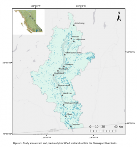
Recent advances in remote sensing technologies have improved the opportunities available for creating comprehensive wetland inventories. In Canada, current nation-wide inventories were found to be patchy, incomplete, or limiting in that they do not account for terrain morphology at scales relevant to hydrologic processes that influence wetland presence and dynamics. The current Okanagan wetland inventory, although a good first step, is incomplete. The data were collected from field-based studies as well as aerial photo interpretation. This method likely was unable to pick up on small, ephemeral or forested wetlands and there was no temporal component associated with the data. In addition, this method is labour-intensive and time consuming, making it difficult to replicate.
The ability to identify and differentiate wetland types using earth observation satellite and LiDAR data combined holds great promise for conserving wetlands at scales relevant to ecological processes, including wetland connectivity and biodiversity, and for informing resource management.
Through my research, I aim to create a replicable model to identify and classify wetlands in the Okanagan using remote sensing data. From here, I will be exploring secondary studies such as biodiversity, connectivity and implications of climate change.
Research Presentation: Remote Sensing of Wetlands – March 9, 2020
This research would not be possible without funding support from OBWB and Mitacs.