Last year Google launched Project Sunroof in 3 states, since it’s launch it currently covers 9 states in America.
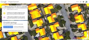
So how does it work? Project Sunroof allows homeowners to find their rooftops on the map and determine if they’re suitable for solar panels. Essentially, it is using the same high-resolution aerial imagery by Google Earth to help calculate a roof’s solar energy potential.
Once the potential customer finds their home, the program can figures out how much sunlight hits that rooftop throughout the year, taking into account factors like shade, roof orientation and local weather patterns. Potential customers can also enter the amount of their typical electric bill for more customized results.

All of this information is combined to create an estimate for how much a given household could potentially save by going solar. The site also helps customers connect with local solar providers.
This is not only a smart way to capitalize on the untapped solar market in America, but it’s also a fun and visual way to attract more consumers and drive purchases of solar panels. Although it has only been launched for roughly 6 months, it would be interesting to see if there are any changes in purchase behaviour of solar powered panels in those states.