Subjectivity masked as objectivity is a common trope, it turns out, and not just in maps!
Over the long weekend, I completed a New York Times Survey, that takes your pronunciation of words, and specific terms for things like a long sandwich, or the strip of grass in the middle of road, and uses your answers to place you/or where you’re from. Turns out the world I use for something located diagonally across a street, “kitty-corner”, was able to pinpoint me to either Seattle or Tacoma (sadly this was only an American Map).
Take the quiz here: http://www.nytimes.com/interactive/2013/12/20/sunday-review/dialect-quiz-map.html
Also very interesting is the similar vein of research being done at Cambridge that maps all world Englishes. You can contribute your own personal answers, or simply confirm, for example, that ‘washroom’ really is a Canadian thing! See below
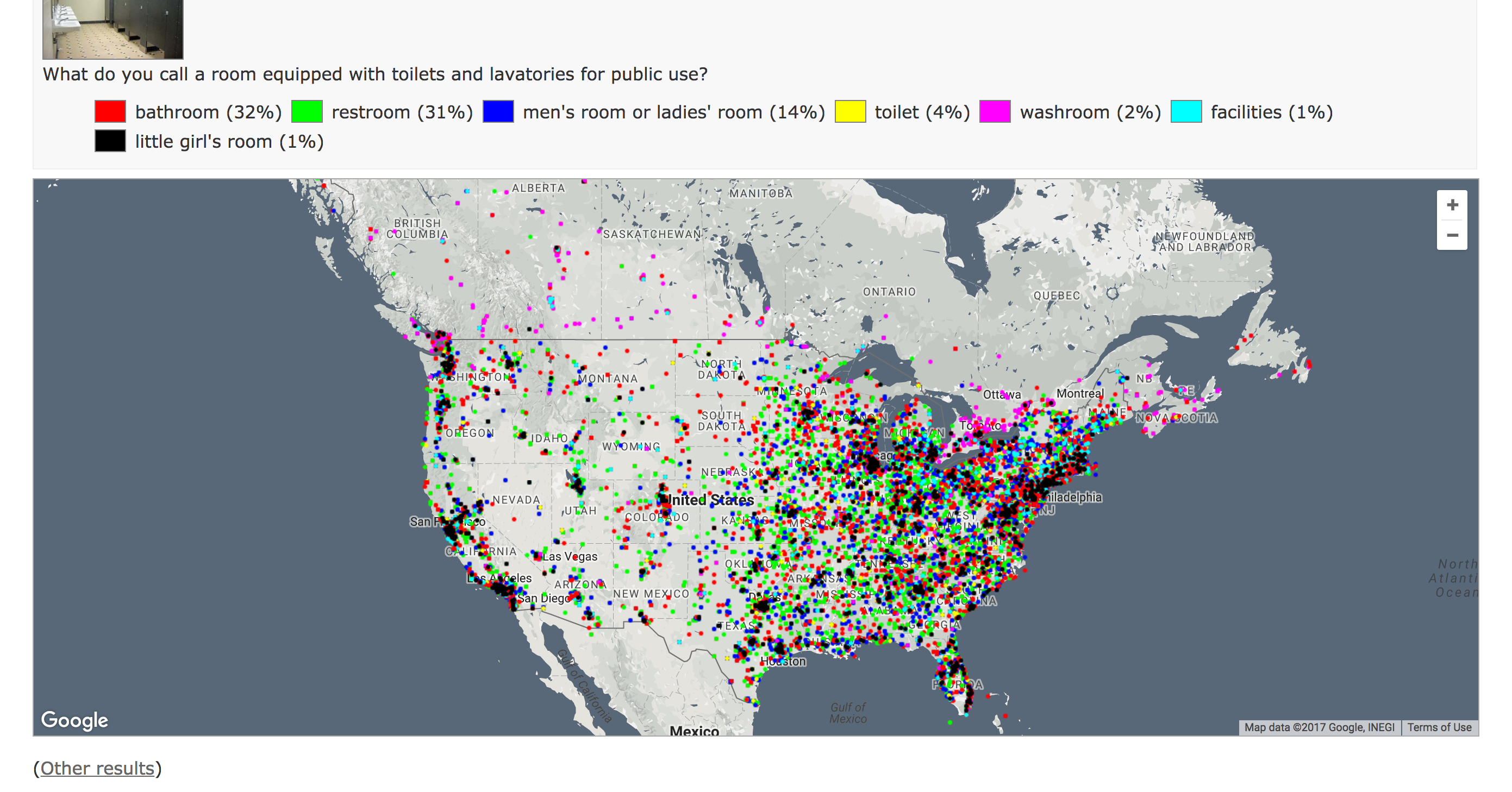
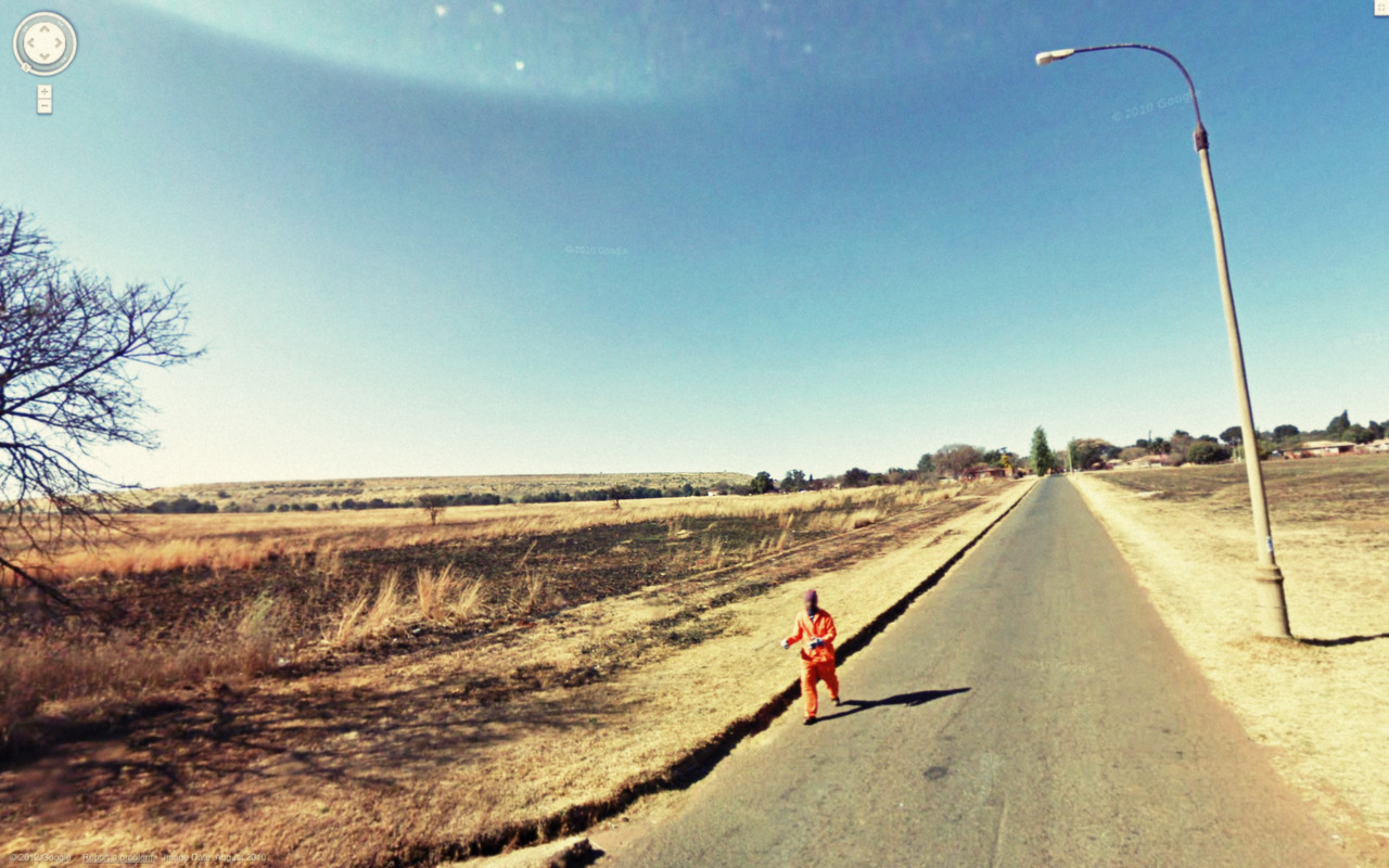 Image credit: http://9-eyes.com/
Quotes from Susan Sontag, On Photography, 1977:
“Strictly speaking, one never understands anything from a photograph….Today everything exists to end in a photograph.”
“The camera makes everyone a tourist in other people’s reality, and eventually in one’s own.”
“Needing to have reality confirmed, and experience enhanced by photographs is an aesthetic consumerism to which everyone is now addicted. ”
[[[[//////////////////////////\\\\\\\\\|||||||||||||||||||||/////]]]]]9 –Eyes is a project by Canadian Artist Jon Rafman. Begun in 2009 and continuing to the present, this series is a sort of street photography taken from within mapspace. Rafman takes screenshots from the ever-evolving, distorted, and stitched web of Google Street View panoramas and posts them to this blog: 9-eyes.com. The artist, rather than strolling physical streets, drifts through cyber geospace and retroactively finds the ‘decisive moment’ described by Cartier-Bresson in poetic, violent, turbulent, pastoral, comical and ultimately ambiguous scenes. I would like to use 9-Eyes to dismantle Google Street View’s supposed neutrality.
Maps have tended to focus on geographic space and index human artifacts– our roads, houses, tweets, traffic patterns etc—as opposed to humans ourselves. Google Street View is both laudable and problematic for the inclusion of people within its archives. As some of Rafman’s images begin to show, the subjects captured are of a certain demographic. This is because, the street view cars equipped with (originally 9) but now 15 cameras only venture out in the brightest (shadowless) hours of the day, meaning most white collar workers are not occupying the street. Instead, the privacy of prostitutes, criminals, the elderly, and children to name a few, is arguably unevenly violated. While the algorithm blurs faces and license plates, it is far from perfect, and people are often identifiable. On the other hand, the repository of images of people could be mobilised for good, to illustrate, argue or prove.
However, this blurring of identity mirrors and exacerbates our lack of empathetic recognition of fellow humans. Rafman’s images are mined from countries around the globe, and divorced from their immediate context we struggle to understand the circumstances of each image and the identity of the people within in. I read this as a comment on the digital proximity yet estrangement with others we face on social media today. The presentation format of a never-ending blogroll also contributes to this blur, as images meld together in front of the viewer, without reference.
The endlessness of Rafman’s blogroll critiques another facet of mapmaking and our online culture today: that we are faced with overwhelming amounts of data, information, and even maps available on and through the internet. This also points to another bias in Google’s Street Views. They hide their implicit authorship of the maps, behind the sheer amount of their data. In their totalizing mission, the data takes on a life of its own, they can no longer be seen responsible for the immense amount of it. Instead, it falls on the viewers to find and report any violations, or aberrations in the maps.
Rafman performs a sort of archeology of this data archive. He sifts through this constantly updating mapscape and preserves certain views, recontextualizes, or even maps them. Though originally taken by a computer-driven camera program, digitally stitched together and distorted, Rafman adds a human dimension by finding, and selecting these pictures. While certainly problematic, this has the effect of personalizing the visual data. Rafman’s project shows us how Street View is far from neutral and brings us simultaneously closer and farther than ever from the places and people represented on the map as we look on in amusement, horror, bewilderment and laughter.
LINKS:
This is a great podcast featuring an interview with Pierre Bélanger.
Pierre Bélanger is a landscape architect and urban planner who teaches at the Harvard GSD. He also directs “OPSYS”: a hybrid between a laboratory and workshop that aims at designing ecological systems that can support and promote contemporary urban life.
As the curator of the Canadian Pavilion entitled ‘Extraction’ at the 16th Venice Biennale of Architecture, he called into question what it means for architecture to be complicit in colonial agendas worldwide by revealing how Canada now replicates the systems around the globe that were initially used to set up its notion of sovereignty and its massive resource extraction economy.
Listen Here:
 Follow