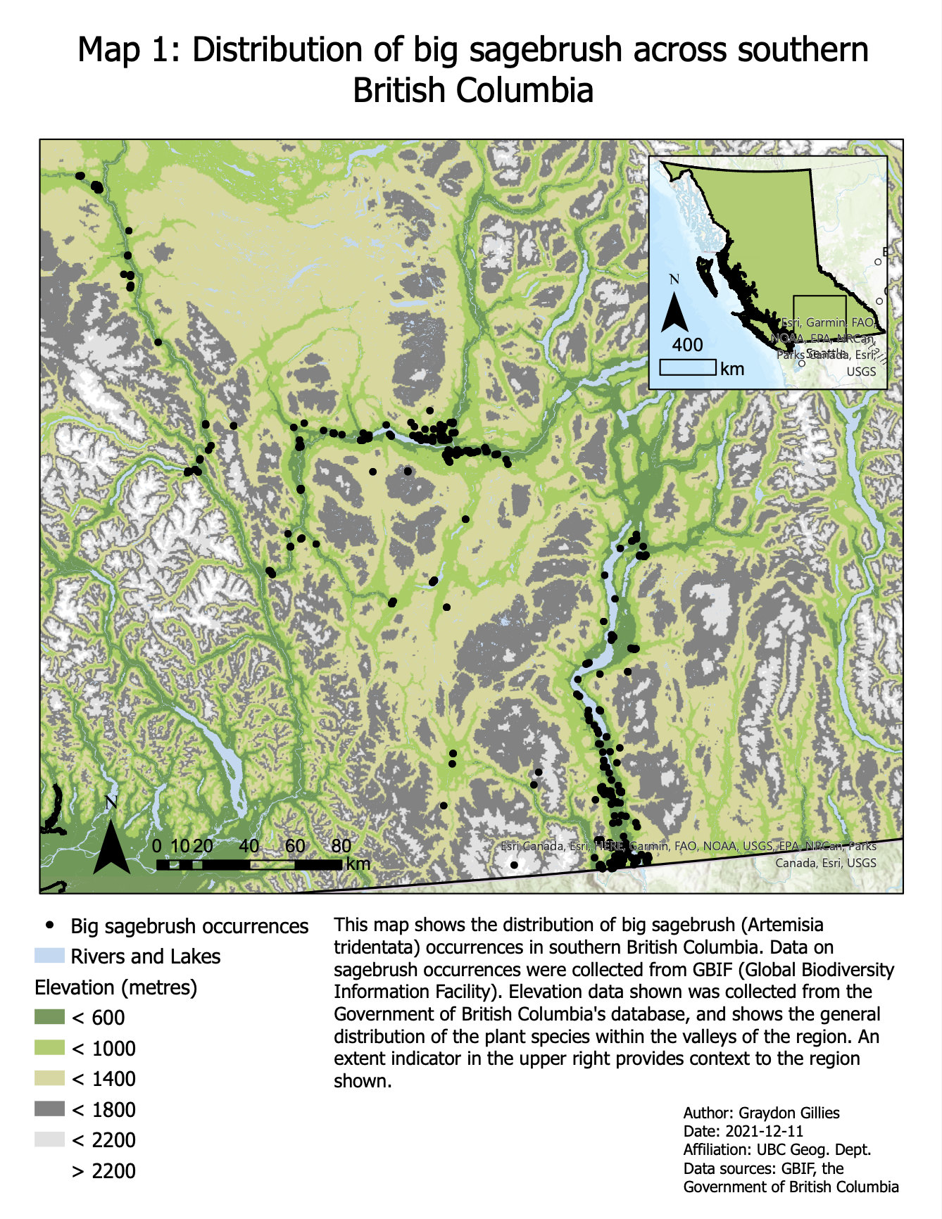
Big sagebrush is found mostly in the low-elevation valleys of southern B.C. To depict this range, the GBIF point occurrences of big sagebrush were displayed with the original DEM data (Map 1). This map shows the entire British Columbian range of the species and all of the northernmost populations besides a small amount of observations in Alberta. It can be seen that the species is generally found at lower elevations within the region and is usually near sources of water (such as lakes and rivers).
Habitat suitability within the current geographic distribution of big sagebrush will decrease under climate warming, and will decrease more substantially under higher levels of climate warming. Panels in Map 2 and Map 3 show the current and projected suitability of each climate scenario. The first panel of both maps shows what the model predicts for the plant’s habitat suitability under current climate conditions. The accuracy of the habitat suitability model can be verified by examining how the current distribution of big sagebrush occurrences matches with this habitat suitability prediction. It can be seen in Map 2a that most of the occurrences are within the highly-suitable (dark green) regions of the map, and none are found within the low-suitability (dark red) regions of the map. This indicates that the habitat suitability model provides a good estimation of the plant’s favoured habitat. By examining Map 2b and 2c, which show how the model results change under changes in temperature and precipitation, it can be seen that the low-elevation valleys appear to have decreasing habitat suitability and take on a yellow colour, indicating more neutral suitability. Simultaneously, the mid-elevation regions just outside the valley appear to become more suitable for the plant. The effects that climate warming has on the projected habitat suitability are quite similar between both warming scenarios, but they are more pronounced and severe in the high-warming scenario. It appears that mid-elevation regions above the valleys become more suitable while the valleys themselves become less suitable, but this analysis isn’t capable of predicting how these changes in suitability will tangibly impact big sagebrush populations in the region.


To more quantitatively examine how the habitat suitability will change across the current distribution of the plant’s range, histograms were generated to display the distribution of habitat suitability across the current locations of big sagebrush, shown in Figures 2-4. It can be seen that the mean suitability of the current GBIF locations decreases by 10 percentage points between current climate conditions and projected low-warming conditions, and decreases 20 percentage points between current conditions and projected high-warming conditions. The shifting to lower suitability values under climate warming, indicating that many of the current locations of big sagebrush may become substantially less suitable. This decrease in suitability is about twice as large under high-warming conditions relative to low-warming conditions.
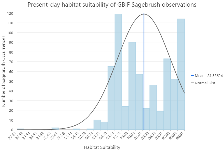
Figure 2: The distribution of current big sagebrush occurrences on GBIF across the model’s predicted habitat suitability under current climate conditions.
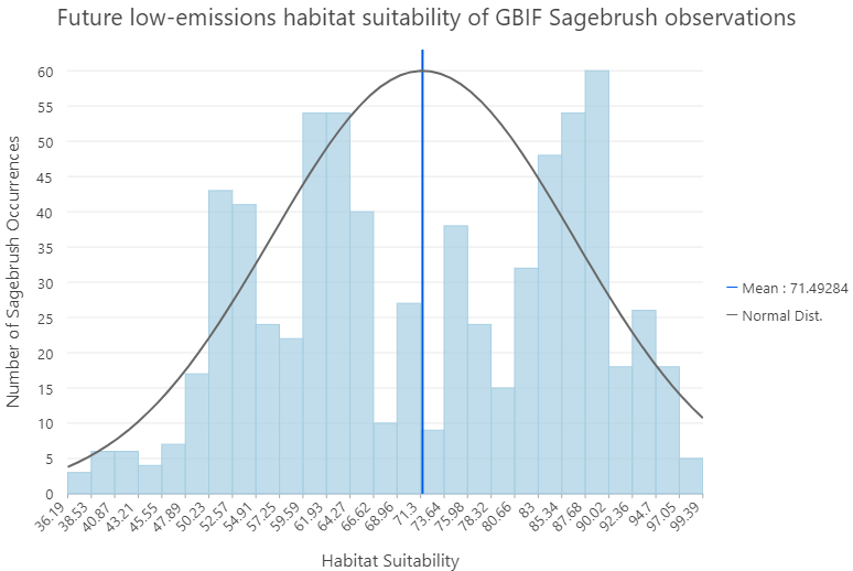
Figure 3: The distribution of current big sagebrush occurrences on GBIF across the model’s predicted habitat suitability under future low-emission climate conditions (2080).
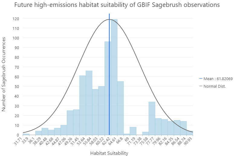
Figure 4: The distribution of current big sagebrush occurrences on GBIF across the model’s predicted habitat suitability under future high-emission climate conditions (2080).
More distant northern regions of British Columbia also exhibit a change in habitat suitability. Map 3 shows the same climate scenarios as Map 2 but on a small scale map that captures the entire province. Parts of southern B.C. such as Vancouver Island and the Greater Vancouver Area become substantially less suitable for the plant (shown by more red colouration), whereas parts of central and northern B.C. beyond the plant’s range become more suitable (as indicated by a transition from yellow to green colouration). Consideration of the habitat suitability in these regions is important despite them being well beyond the plant’s range, as there is a possibility that the species will begin shifting its range into these uninhabited northern regions. If that does not occur, there may also be the opportunity for assisted migration into these regions to ensure the persistence of the species (Hewitt et al., 2011).
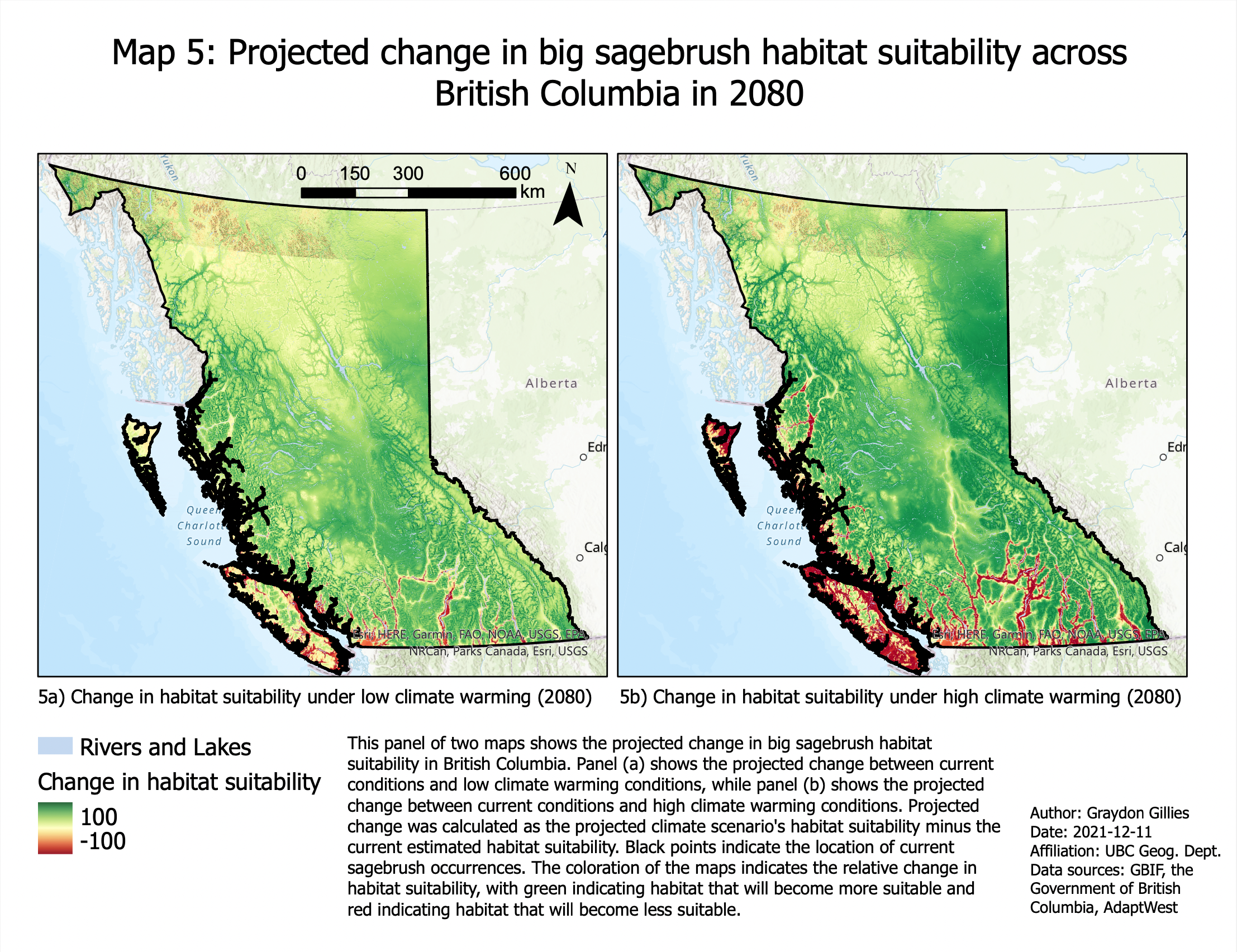
To develop a more visually clear depiction of how suitability is changing across the entire province, Map 4 and Map 5 were created to reflect the change in suitability predicted by the model for each raster pixel. This was calculated by subtracting the current estimated suitability at each pixel from the projected suitability under both future climate scenarios. This calculation could result in a potential range of values from -100 to 100, with negative (red) values indicating habitat that becomes less suitable under the climate scenario and positive (green) values indicating habitat that becomes more suitable under the climate scenario. Values near 0 (yellow) indicate there is little change in the habitat suitability between current estimations and future projections. Both Map 4 and Map 5 show dark redness in the valleys of southern B.C. that the plant inhabits, but this redness becomes much broader and covers a significantly larger area under the high-warming scenario. Under the low-warming scenario there are still many GBIF occurrences that are found in neutral (yellow) or even positive (green) habitat suitability changes, but only a few locations are found in the high-warming scenario that don’t have a negative change of habitat suitability (Map 4). Examining this pattern at a smaller scale shows similar results between both climate scenarios. Much of central and northern B.C. has a yellow-green colour, indicating that much of the province may become more suitable for the plant under climate warming. There are some habitat areas that are projected to decrease in suitability, particularly around Vancouver Island, Haida Gwaii, and southern areas of interior B.C. – though the former two regions are not especially relevant. Despite much of the province becoming more hospitable to big sagebrush under both climate warming scenarios, the current distribution of the plant may face a drastic reduction in suitability, particularly in the high-warming scenario.