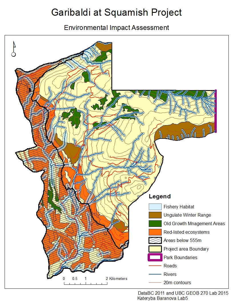
As a natural resource planner, the Northland Properties and Aquilini Investment Group of Vancouver hired me to work on the Garibaldi at Squamish year-round ski resort project proposal. My main objectives were to evaluate the feasibility and environmental impacts of proceeding with the project. In order to accomplish that and demonstrate my results I produced a map that represents the ungulate winter range, riparian areas, old growth management areas, red-listed ecosystems and park boundaries, as well as areas below 555m and nearby roads.
First I conducted an analysis of vulnerable environmental areas in order to exclude them from the project construction area. I gathered data on ungulate winter range, fish bearing streams, old growth forest areas and the terrestrial ecosystem mapping and then used only the data that falls within the project proposal boundaries for further analysis. First I divided the project area to represent areas that are below and above 555m, the area below 555m is shaded to stand out from the rest. Then I identified the areas of ungulate winter range and old growth forest and highlighted them with brown and dark green colours respectively. For fish bearing streams I selected the areas of 50m around streams that are above 555m and 100m around streams below 555m and highlighted them light blue to demonstrate the riparian areas within the project area. I also located red-listed species from the terrestrial ecosystem mapping data and highlighted them orange on the map. Lastly I added the roads layer, which are indicated a red lines to demonstrate already existing transportation routs that can be used for the project.
From my analysis I found that the areas, within the proposed project boundary area, unsuitable for the construction of the ski resort constitute about 55.54% of the total area. 29.92% of the area was below 555m, 6.79% was old growth forest management areas, 7.89% was the ungulate winter range areas, 24.83% was the red-listed species and 30.13% was the riparian zones.
In my opinion the two greatest concerns to the project development is that there is a significant area (29.92% of total project area) that is below 555m and would not get enough snow to maintain a ski resort. This is a very difficult concern to mitigate as it would be very costly to artificially add snow in order for the ski resort to run. The second concern is that the riparian zones also take up a lot of space (30.13%) and besides just that, they also break up the whole area, making it hard to develop a ski resort.
I personally do not believe that the project should be allowed to continue for a number of reasons. First of all there is very little space to construct the ski resort without building onto the areas that I determined unsuitable for construction. The available area, which is only 44.46% of the original proposed area, is all broken up into small segments of land by the riparian zones. It would be extremely difficult and costly to build a ski resort around all the riparian areas and have a route to it. Furthermore, taking into account climate change and rising average temperatures, the 555m boundary line for elevation that is able to maintain enough snow during the skiing season, would most likely rise higher, leaving even less available building space. Lastly, the analysis conducted did not account for noise, light and other pollution from the ski resort and how that might affect the overall wellbeing of endangered species in proximity. Overall, there are too many acquired costs and environmental risks associated with continuing with the project that in my opinion it is simply not worth it.