Landslides are both fatal and costly. In the United States alone, between 25 to 50 people die every year from landslides and approximately $2 billion to $4 billion dollars are spent annually on infrastructure damage. These numbers are expected to increase as climate change has shown to increase the likelihood of landslides. Climate change is affecting the frequency and intensity of heavy rain, which can make slopes less stable by oversaturating the soil with rainwater. This is concerning as it has already impacted many populous areas, including Manipur, India in 2022 and British Columbia, Canada in 2021 (see below). Climate change may also generate more landslides from glacial retreat, permafrost melting, wildfires, and droughts.
The purpose of this website is to aid landscape architects, other design professionals, or anyone else who is interested, in understanding landslides and how to mitigate landslide-risk through design. We see that this website is particularly important for students since evaluation and mitigation of landslides is not commonly taught in landscape architecture programs. We hope to support and empower designers in their initial understanding of the landslide phenomenon. It is important to note, however, that this website is only a general resource and a professional landslide expert, such as a geotechnical or civil engineer, should be consulted prior to construction.
The site is divided into multiple sections:
- Under basic concepts, one can learn more about what a landslide is, how they occur and the different types of landslides.
- We have developed two easy-to-use tools for site analysis and have included them in this blog. The soil matrix is a low-tech tool that can be used to understand which type of landslide is most probable on a site while the ArchGIS-based tool shows the probability of landslides in an area.
- The Mitigation section contains information on how to prevent landslides through various techniques and technologies as well as some interesting precedents.
- All of the articles, websites, and other resources that we used to create this blog are listed in the annotated bibliography and bibliography matrix sections.
For any additional questions or fore more information, please contact us either directly through email or in the comment forum. A search bar is also provided at the bottom of every page in order to search the site for keywords.
Cover photo from redding.com
Recent Landslides in BC
Pemberton Mudslide
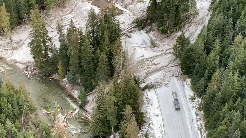
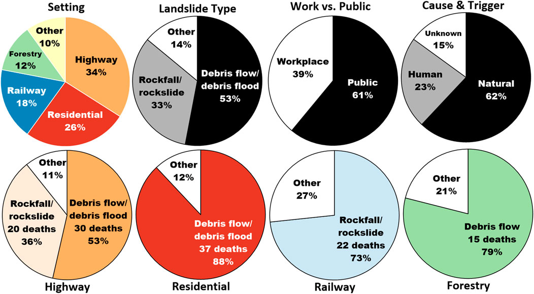
In November 2021, a series of floods and mudslides occurred throughout southeast British Columbia and northeast Washington State due to a prolonged atmospheric river. While the extensive flooding in the Fraser Valley severely damaged property and infrastructure, displacing thousands of people, thankfully there were no recorded injuries or deaths from the floods. In the more mountainous terrain near Pemberton, about a two hour drive from Vancouver, there was a mudslide that swept cars off of the highway, killing five people. This is quite shocking since fatalities from landslides are only about one per year in the last decade despite landslides being the most common natural disaster in British Columbia. Mudslides, also known as debris flows and debris floods, are the most common landslide type and kill the most people, which is alarming since the frequency of mudslides are expected to increase due to increased rainfall. This landslide serves as an important event as we may see more like it.
Tank Hill (Lyton) Landslide
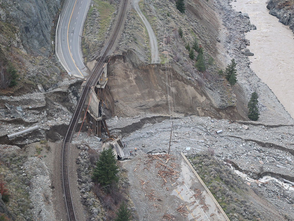
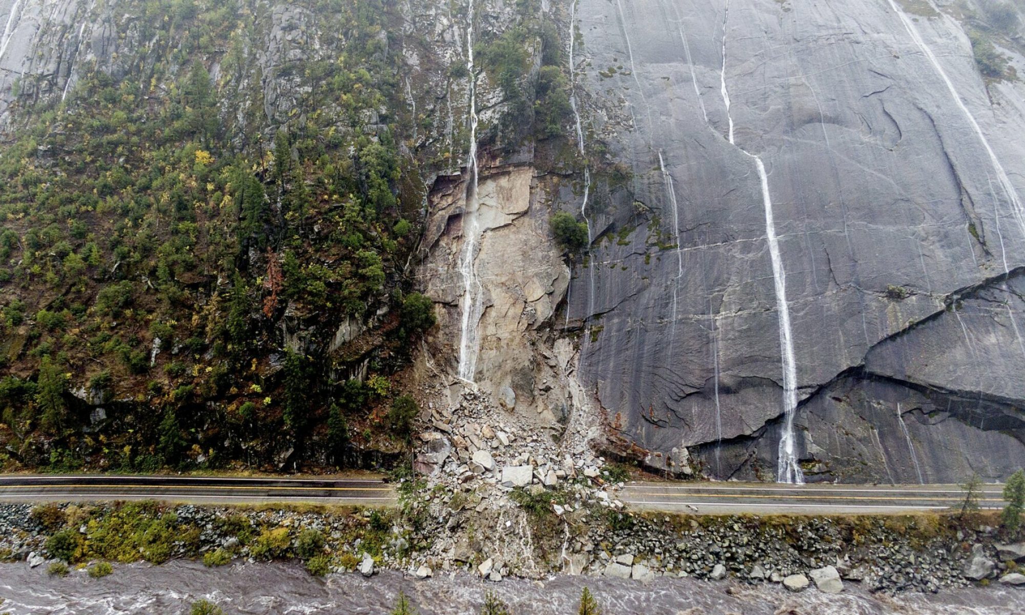
During the same atmospheric river event that triggered the mudslide near Pemberton, other less fatal landslides occurred along other highways outside of Vancouver. These series of landslides blocked every highway to the north and east of Vancouver, leaving the only land travel route to the rest of Canada through the US. While each of these landslides are important case studies in landslides destroying critical infrastructure, the landslide at Tank Hill in the Fraser Canyon (Highway 1) is significant for several reasons. Firstly, the landslide caused the highway to slip under a railway track and shear off seventy meters of the road. The damages not only halted road access, requiring work crews to construct a detour while the lengthy rebuilding takes place, but also stopped CP Railway from operating. This highlighted the fragility of British Columbia’s supply chain route as trains, which carry about two-thirds of containers through BC, and semi trucks rely on networks carved into the side of the Fraser Valley. Secondly, Tank Hill was identified as high-risk of landslides and flooding after the 2021 wildfire season. This section of Highway 1 is just east of Lyton, which was devastated by a wildfire only a few months earlier in June. Wildfires increase risk of landslides since burned soils tend to repel water, reducing infiltration leading to runoff generated debris flows, as well as reducing soil stability by burning plant roots that help anchor the slope. With critical infrastructure in landslide-prone areas along with an increasing frequency of landslides due to more wildfires and heavy rainfall, it is very likely that we will experience more landslides that affect the transportation networks we rely on. That is, unless we are able to intervene and mitigate the risks in areas like Tank Hill.
Elliot Creek Landslide
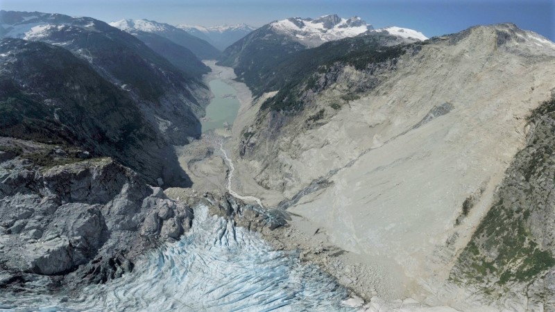
On November 28th, 2020 a massive landslide near the West Grenville Glacier, about 220km north of Vancouver in the Coast Mountains, triggered a tsunami in a glacial lake and outburst flood that decimated the area. There were no injuries or deaths as the event occurred in an remote area, however the geohazard cascade that charged 10 km down slope caused widespread channel erosion and destroyed critical salmon habitat. Since no one was nearby to witness the landslide and the area is difficult to access, researchers at the University of Northern British Columbia used remotely sensed observations, including seismic energy, laser mapping, satellite imagery, and computer simulations, to reconstruct the series of events. The modeled results of the Elliot Creek landslide reveal that 50 million tonnes of rock (equivalent to the mass of all automobiles in Canada) detached and slid 1 km towards a glacial lake. About 60% of the rock mass entered the lake, causing a tsunami 100 meters in height and resulted in an outburst flood that traveled 9 km into Bute Inlet. The fresh water, sediment, and organic debris that entered the marine environment caused a sediment plume and changed the water temperature, salinity, and oxygen levels in the inlet.
The trigger for the event is unknown, however it is known that rapid deglaciation played a key role (similar to the Bondo Landslide) as it led to debuttressing of the base of the slope and created the glacial lake. With increased glacier retreat there will be a higher probability of destructive geohazard cascades to occur. While they tend to occur in mountains far from human settlements, they can severely damage the ecosystems that we rely on. In the case of the Elliot Creek landslide, the disaster destroyed the spawning grounds of chum, which were already declining in numbers, that the Homalco First Nation rely on. Therefore it is crucial that we predict and mitigate the effects of landslides caused by glacial retreat.
Recent Landslides Worldwide
For an excellent resource on recent landslides worldwide, please visit The Landslide Blog. This is continually updated by Dave Petley and provides insightful commentary on significant landslides around the world.