Human as sensor 1

I am interested in the mapping in bottom up approach. Using human as sensors can always recall the forgotten substances which are in fact existing but become  invisible due to the limited information and access, or absence of interest of the top-down mapping group. I will keep on looking for more various ways of bottom-up mapping.

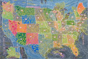
Human as sensors :”Recently a great deal of attention has been devoted to the concept of sensor networks. The observational objectives of Earth science, as well as the objectives of security and surveillance, can be addressed at least in part by the installation of networks of sensors across the geographic landscape. Commonly cited examples include the network of video monitors in many major cities, proposals to instrument the ocean and seabed with sensors in the interests of science and early warning of tsunamis, and networks of traffic sensors that can provide useful information to planners, as well as real­time pictures of congestion.”

“Goodchild Michael F., “Citizens as sensors: The World of Volunteered Geography”, GeoJournal (2007):211- 221, acccessed  May  17, 2017, doi:10.1007/s10708-007-9111.”


History Unwired is a walking tour through one of Venice’s more hidden neighborhoods, delivered over location-aware, multimedia phones and PDAs. Developed in 2005, this project was a first-ever mix of mobile video, animation, audio, and bluetooth locative technologies in the tourism sector. The tour takes visitors around the neighborhood of Castello, guided by the voices of Venetian citizens who depict a particularly local experience of art and craft, history and folklore, public and private spaces.

Delta Primer: a field Guide to the California Delta by Jane Wolff

In this book, Jane Wolff hand draws images on cards to map, describe and analyze the California Delta. See article for more info.

If anyone has a copy of Jane Wolff’s book, I would like to borrow it.

The Wilderness Downtown

In an interesting use of mapping technology, Arcade Fire created an interactive music video with Google Maps that transports you to the town you grew up in.

“Choreographed windows, interactive flocking, custom rendered maps, real-time compositing, procedural drawing, 3D canvas rendering… this Chrome Experiment has them all. “The Wilderness Downtown” is an interactive interpretation of Arcade Fire’s song “We Used To Wait” and was built entirely with the latest open web technologies, including HTML5 video, audio, and canvas.” (chromeexperiments.com)

Created in 2010 and directed by Chris Milk.

Click the link below, enter your home town and experience the experimental production:

http://www.thewildernessdowntown.com/

(Its recommended you watch the video with Google Chrome)

Contested Maps: Kitsilano

Enlarge

vancouver-bc-may-18-2017-sam-greers-map-at-all-nations
Mapping used as a means to lay claim to land.

Arlen Redekop / PNG | Source: http://wpmedia.vancouversun.com/2017/05/vancouver-bc-may-18-2017-sam-greers-map-at-all-nations.jpeg

A (true) story in our own back yard of a man and a map and some lies and some land. And also proof that if you hang onto old maps you can make good $.

A little sneak peak:

The CPR tried to put a rail line and telegraph poles through Greer’s claim, but he tore up the rail ties and cut down the poles. The railway retaliated by tearing his house down when he was away, twice.

Hilarity ensues at The Vancouver Sun.

Visualized Stravinsky

This amazing work of animated graphical score captures multiple dimensions: rhythm, pitch, volume, instrument, and tone quality. The work translated one of the greatest and most complex pieces of the modern musical history: Stravinsky’s Rite of Spring. In the description blow, the author thoroughly explained the idea, method, and program used in the translating process.

Can a series of photographs be a map?

An interesting read about how the Athabasca-Mackenzie River Basin was photographed and documented. What are the implications of this form of mapping? Could the way this area was mapped have lead to the rise of the resource exploitation of the Alberta tarsands (which this area is now known for)?

http://www.aupress.ca/books/120176/ebook/04_Finkel_et_al_2010-West_and_Beyond.pdf

PARIS’ CBD LA DÉFENSE STRATEGIC MASTERPLAN

http://www.awp.fr/project/paris-cbd-la-defense-strategic-masterplan/

In 2012, public institution DEFACTO, selected AWP, Office for Territorial Reconfiguration, (Marc Armengaud, Matthias Armengaud, Alessandra Cianchetta) in partnership with HHF, to provide design and implementation guidance for La Defense, Central Business District. The objective was to conceive a new strategic master plan for the entire (161 hectares) site that addressed issues of public space—green space, urban infrastructure, circulation, transportation and site evolution— specifically as they relate to the 30 hectare slab. —Continue article on website.

Zhongshan Road Map

Designer: Architecture Drawing Studio

Year:2014

Size:40×40 in.

Location: Haikou, Hainan Province, China

110.351325N, 20.049624E

Invited by the the 2nd Haikou International Youth Experimental Art Festival in 2014, Drawing architecture studio created drawings for the Qilou Old Street in Haikou. Qilou Old Street was built by Chinese businessmen who traveled overseas in 19th century. The architecture here is a fusion of European and Asian styles and is also influenced by Indian and Arabian architecture. Chinese government today tries to protect these heritages but their protection work is only focusing on the elevation. But the studio was more interested about the life happening inside buildings. However, they couldn’t make further research since there was a time limit and they were not allowed in.

The author was inspired by Piranesi’s Campo Marzio plan, which was created by a combination of imagination and archaeology. Thus they envisioned an indoor & outdoor urban space based on the architectural outlines extracted from their survey, which can be seen at the upper half of the map.  The lower half of Zhongshan Road depicts the plans of the roofs with the figure-ground method from Nolli Map. But the boarders between the figures and grounds are blurred by the inversion of black and white.

The combination forms of two different style Roman maps represent two different ways to read about cities. One is to explore the city from the ground floor plan, showing more about space inside buildings. One is to explore the city from the roof plan, showing more about space between buildings.  This studio also intended to record everyday life happening in the buildings. So they added a lot of detail elements like furniture and cars to indicate the local’s activities. For example, we can see the street is in a messy state with tables, chairs, beach umbrellas and cars, which give us a sense that life here is busy and alive. And these furniture also help readers to know the scale of the place.

Image credit from: http://www.d-a-s.cn/en/projectdetail.php?currcategory=drawing&page=5

LARC582D_URBAN REPRESENTATIONS: MAPPING_THE INVISIBLE

Spam prevention powered by Akismet