A lattice represents a surface using an array of equally spaced sample points (referred to as mesh points) that are referenced to a common origin and have a constant sampling distance in the x and y directions. Each mesh point contains the z value at that location, which is referenced to a common base z value, such as sea level. Z values for locations between lattice mesh points can be approximated by interpolation based on neighboring mesh points.
Lattices and grids are stored using the same data model. This data model can be interpreted as a lattice or a grid. The lattice interpretation of the data model considers each mesh point as a surface value at the center of a cell; it does not imply an area of constant value. In contrast, the grid interpretation of the data model considers each cell as a square area with a constant attribute value. All locations within the cell are assumed to have the same value. The data model stores the z values in one of two formats: as integer or floating point numbers.
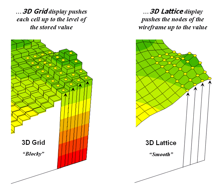
The lattice interpretation views each mesh point as a surface value at the center of the cell whereas the grid interpretation considers each cell as a square area with a constant attribute value.
Floating point grids are frequently used to store continuous data. The surface z values are stored as single precision floating point numbers. This precision is more than sufficient for most applications. Floating point grids, in contrast to integer grids, do not have an associated Value Attribute Table (VAT).
Integer grids, used to store both categorical and continuous data, have a Value Attribute Table (VAT). A VAT contains at least two items, VALUE and COUNT, which are stored as integer values. The VALUE item stores the value associated with each zone of the grid. A zone is two or more grid cells with the same value; the cells can be adjacent or disconnected. The COUNT item stores the total number of cells in the grid that belong to the zone. This format conserves computer resources by storing only one record for each zone of mesh points with the same VALUE. As with other feature attribute tables, other items can be added to the VAT to store attributes of the zone. A lattice surface can be derived from any numeric attribute in an integer grid by giving the name of the grid followed by a period (.) and the name of the item (e.g., grid.item).
Command execution times are often faster with integer grids. Integer grids also require less disk space for storage. The added disk space required to store the integer grid’s VAT is more than offset by the compression used in the storage of integer data. Floating point grids are not compressed. Additional savings can result on relatively flat terrain since all locations with the same value are stored as a single record in the VAT. If your application does not require the level of precision offered by floating point representation, consider processing your lattices (and rasters) as integer grids.
Taken from the 9.3 Arc/Info Help File (ArcInfo Workstation Arc Doc files).