Author Archives: shuhui xu

Basho’s Journey

Matsuo Basho is one the most outstanding Japanese poets of haiku – a short form of Japanese poetry (Basho, 1996; Basho & Barnhill, 2005). He was born in 1644 in Ueno, Iga Province, to a low-ranking samurai family. Basho started writing poems as early as 1662. He was part of the Danrin School, where he participated in numerous competitions. He would later become a judge of poetry competitions and acquire students of his own, become a lay monk, and establish his own poetry school. Basho’s poems were influenced by his intimate relationships, especially with friends, as well as Zen and Chinese Daoism (Basho & Barnhill, 2005).

Feudal stability characterized the Tokugawa Period (1600-1868) (Basho & Barnhill, 2005; Downer, 1989). Hence, travelers could travel safely. Improvements in social mobility facilitated the widespread of arts and throughout Japan, regardless of class, with the merchant class taking on the arts. The Haikai no renga, a comic-linked verse, was significantly popular among samurai and merchants. This is how poetry reached Basho. However, in 1666, Basho’s friend Yoshitada died suddenly, making him consider leaving secular life. The flourishing arts made it possible for gifted writers to remove themselves from their daily life and become master poets. This is the path that Basho followed (Basho & Barnhill, 2005).

In the late spring (May) of 1689, Basho set off for a 2,000-kilometer journey from Edo (currently Tokyo) to the northern interior of Japan, as indicated in figure 1 (Basho & Barnhill, 2005). This journey happened to be among the last one, and it generated the infamous The Narrow Road to the Deep North (Oku no hosomichi). When starting, Basho admits feeling old and frail, but he felt compelled to make this journey. He dressed like a monk, carrying a wide-brimmed sedge hat and bamboo staff. As a lay monk, he owned nothing, relying on friends, disciples, and admirers (Downer, 1989).

Basho traveled for many reasons, including for religious and poetic purposes. At the time, traveling or wandering the countryside was viewed as an ascetic practice that helped shape and sharpen sacred visions and poetic creativity (Basho & Barnhill, 2005). Additionally, going on such journeys helped ascetics, monks, and poets remember those who had died before them and their legacy, as observed in Basho’s visits to monasteries and graves of famous people in his historical timeline. He also traveled to acquire more disciples (as he was a master in his own school) and spread his poetry throughout Japan.

It seems that to Basho, travel was more about the experience than the destination. From his poems, one can deduce that he walked to reflect and interact with people, nature, and culture. When leaving Edo, for example, he feels burdened by the goodbyes from family and friends. Although he is old and frail, he cannot leave these memories behind as a human being; it is his responsibility to carry the burden of sustaining relationships with friends and family rather than walk alone. Even so, he is propelled to keep moving on, whether through friends or to reach places, while never forgetting memories, and creating new friends, or finding new encounters at every turn (Kerkham, 2006). Therefore, this sugoroku is intended to be a game played with friends. As players experience Basho’s journey, they learn more about Japan and various essential aspects of the journey. Drawing from Basho’s poems, these experiences are worthy particularly because they represent the temporality of life.
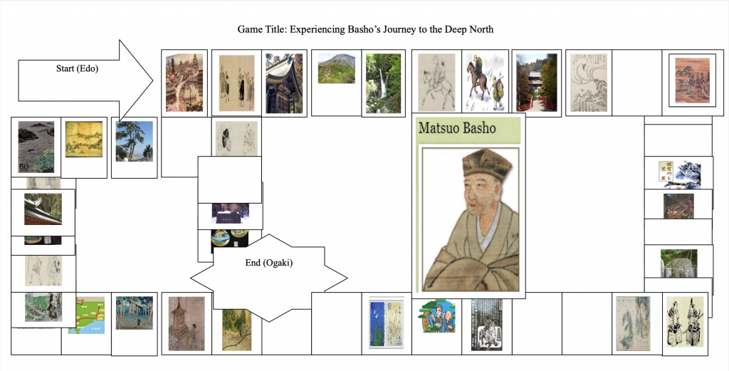
Game Instructions:

Start point: (Edo)

End point: (Ogaki).

Number of players: 2-4.

All boxes, regardless of size and with or without visuals, hold equal importance. Note that only one player (the first to get to Ogaki) will be crowned Basho. The game ends when the first player finishes the game. If all players are unsuccessful in any of the steps, they stay in that stage until they are able to break through and continue their journeys. 

The Shortest Way to Ogaki:

Roll numbers 1 and 3 when the game starts and jump past the Shirakawa Barrier (step 11). When successful, the player is allowed to cast the dice again. If the player gets dice number 1 or 6, they jump past the Great Gate at Date (to step 22). The player then rolls the dice again twice. Dice number 3 and 1 take the player past the Shitomae Barrier (Step 33). The player then casts the dice again. If they get dice number 2 or 5, it is game over as that skips them to Ogaki, the finishing line. 

The Long Way to Ogaki:

References:

Basho, M. (1966). The Narrow road to the deep north, and other travel sketches (Vol. 185) (N. Yuasa, Trans.). Penguin.

Basho, M., & Barnhill, D. M. (2005). The narrow road to the deep north. In Basho’s journey: The literary prose of Matsuo Basho (D. M. Barnhill, Trans.). State University of New York Press.

Downer, L. (1989). On the narrow road to the deep north: Journey into a lost Japan. Vintage. Kerkham, E. (2006). Matsuo Basho’s poetic spaces: Exploring haikai intersections. Palgrave MacMillan.

Maps defined–Chikyū bankoku sankai yochi zenzusetsu (1790)

In “Maps are Strange,” Berry (2006) describes a map as a graphic representation where a combination of codes is used to construct the environment. In premodern and early modern mapmaking art, the most common codes could be classified as iconic, linguistic, and presentational. This essay will focus on these codes and their appearance in the chosen map. The selected map is the 1790 Chikyū bankoku sankai yochi zenzusetsu, roughly translated to Sekisui’s map of the world.

Berry asserts that constructing a map is vital in helping the audience pick out and create important constructs concerning that space. For example, Sekisui’s map of the world has Asia (or rather China) in the middle. This is significantly different from popular maps, such as the Mercator projecting. This map puts Africa and Europe, with America and Asia on the sides, at the center to indicate the power relations bestowed by colonialism and modern-day politics, which involves an underdeveloped Africa due to European and White imperialism. Similarly, Sekisui’s map of the world alludes to China’s centrality in the world. In the old days, China referred to itself as the central kingdom surrounded by its tributes, such as Choson Korea and Japan. By putting China at the center, the map creator communicates that China was the most powerful empire, and the world revolved around it just like colonialism made Europe the king.

According to Berry (2006), the iconic code inventories the environment by communicating the features of a space the mapmaker chose to represent. Sometimes, the map might have a key to help the audience understand the representation and logic used. The most common iconic signs are line, which indicates things that take a linear or line appearance, such as roads and rivers, figures, such as triangles to mean a mountain or circles to suggest cities, and color blocks to show significant differences between signs, such as deep or shallow tints to signify power differences.

The chosen map shows these three codes in profound ways. For example, lines are particularly easy to identify in contents and regions that are not densely populated, such as Africa (white), Europe (yellow), North American (slightly reddish), and South America (bluish). South America has more lines than other continents. These lines appear to signify rivers rather than roads because, in 1790, not many roads would have been highly developed, as extensively as indicated in this map.

This map has many figures. Most are hard to understand due to clarity issues within the diagram and the Chinese letters that often have a Japanese feeling. However, one can see raised regions to mean mountains, joined raised places to signify a range, and the dots to indicate population. Notice how Asia has more dots than other areas, thus asserting its status as the most populous empire in humankind’s history.

Last but not least are the hues to indicate differences. For instance, the map creator used white for Africa, yellow for Europe, red for Asia, orange-red for North America, dark blue for South America, and dark red for the Antarctic border. It is hard to determine why these colors were used. However, drawing from the history of Europe and Asia, such as the spread of Christianity and colonization, one can argue that Europe and China were in perfect contradiction to one other despite their growing visibility in global politics. Although the map has a Japanese effect, the relative powerlessness of Japan at that time, including self-isolation and its relations with China indicate that China was more powerful.

Berry (2006) argues that codes show three more features: stability, generic, and versatility. First, stability means that a particular element within a map will mean the same thing every time it appears on the map. For example, the lines in each continent indicate rivers. I arrive at this conclusion because the lines occur and increase in frequency when the raised figures showing mountains are present and many. That is why South America has more lines, but short and irregular, possibly suggesting a river basin or system, such as Amazon. In Africa, the lines are more continuous and last longer, indicating many long rivers, such as the Nile.

Second, generic refers to the “limited, fixed, and putatively standard variables” (p. 64) that remove the life from each representation and imbue it with generic characteristics, such as lines to indicate rivers and dots to mean people, regardless of the unique aspects of each region.

Third, versatility speaks to the representation of finely visible and invisible things, such as social constructs or environmental concepts. For instance, many rivers and high places in South America could allude to its fertility. In contrast, the widespread representation of this in Africa could indicate that some regions are wet, whereas the vast spaces in the center are either drier or unexplored. Unexplored is a better perspective considering that even though the map indicates that the Antarctic region is unpopulated, the areas below Africa and South America have lighter hues to indicate their unexplored nature. Again these are just speculations as the map’s keys are not clear.