Author Archives: tianqi chen

A filial daughter’s trip of the Tokaido

Tianqi Chen

Game Commentary:

Filial piety, requiring respect, obedience, and care for one’s parents and elderly family members, was one of the most significant concepts of Confucian values, and a heavy influence on East Asia, including early modern Japan. The classic Confucian expectation of women’s filialness was raised in Liu Xiang’s Lienü Zhuan, emphasizing the highly idealized “exemplary woman” (lienü) as a model for behavior and comportment (Yonemoto, 2017). Within patriarchal Confucian society, the standard of the exemplary woman is based on her devotion to men, such as a husband, father, son, or teacher, and to family honor. Through sacrifices, women offer benefit to others, constituting one of their virtues (Yonemoto, 2017). In the Edo period, a woman’s filial piety was defined by serving her husband’s parents and bringing honor to her family through marriage. Ito Maki (1797–1862), was a commoner woman who was the eldest daughter of a prominent physician in Mimasaka Province. Her father, Kobayashi Reisuke, was a physician with a broad intellectual network and a student of Western science (Yonemoto, 2017). Maki received a good education and was able to express her filial piety and longing for her family of origin in her writing in later days. Maki’s family underwent various traumatic experiences, which profoundly influenced Maki’s life and created a filial bond of attachment between her and her parents. Maki was adopted by her childless uncle Kōzaemon, and she moved from Mimasaka to join her uncle’s family in Edo. Maki’s uncle Kōzaemon has higher social status than Maki’s father. He had acquired hatamoto status (Yonemoto, 2017).

Because marriage in the Edo period was about equal social status, through adopted by her uncle, Maki could raise her social status and marry into a better family, fostering a good reputation for her natal family. Therefore, this journey from Maki’s hometown Mimasaka to join her uncle’s family in Edo became a life-changing choice that would define the rest of her life. Based on historical evidence, Maki chose to be adopted by her uncle and married into a better family, thus fulfilling her duty of leaving a good reputation for her natal family. However, Maki also paid the price. She was not allowed to contact her original family at all, even though she missed them dearly. Maki could only express her filial piety to her parents by writing letters, and she once mentioned that she felt delighted when she saw the map of her hometown. Unfortunately, Maki never returned to her hometown for the rest of her life. She noted in her letter a desire to fly back to her hometown like a bird. Although women had very few choices in the Edo period, there were still some choices that women could make to escape the fate of marriage, such as serving in a wealthier home. Therefore, this map game adapts Ito Maki’s real-life story by giving her a second option to serve in a household of rank and to raise her stature and that of her natal family through hard work. Two routes are given to her as two different options: go to Kyoto and work, or go to her uncle’s house at Edo. These two routes both travel via the Tōkaidō highway, the most essential and convenient route during the Edo period, following the fifty-three post stations (limited here to six critical post stations).

Game Instructions:
Material and Procedure:

  1. Two single six-sided dices
  2. The map board with the number of each station, and each station has two numbers
  3. The question cards
  4. There are two options for the player: one is to go to Kyoto and work, the
    other to go to Maki’s uncle’s home in Edo–the player make the choice.
  5. After the players make decisions and roll the two dice, the number of dices the players
    throw determines the station where they land.
  6. When the players arrive at the station, they must answer the common knowledge
    questions about Edo Japan, and only when they give the correct answer can they move
    on.
  7. The players who arrives at their destination first is the winner.

The question cards with answers:

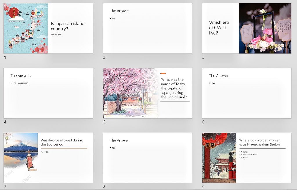
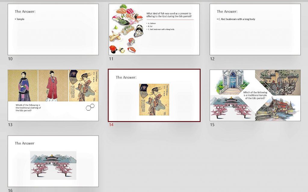
Power point link to question cards:
https://docs.google.com/presentation/d/17BGoX9Zu06KoXmkvrkhSngXmKWHmRXkQ9
Vmq26ImVUw/edit#slide=id.p1

The Game Board:

The link of the dices:
https://docs.google.com/presentation/d/1O5BAYfX4uRIYETumdkKtKCzHw84T_pR3Fu-3
O-fBiiw/edit#slide=id.gd3777506be_0_12

The appreciation of the map Tōkaidō bunken nozu


Quoting from the Traganou:

The major characteristic of the map is its combining precise topographical descriptions with vigorous details of life. Indeed, the illustrations added by Moronobu transformed the map into a vivid pictorial illustration of the culture of traveling in the Edo period. Such illustrations focus on the celebrated ‘floating’ aspects of the culture of the road, elements that are ephemeral and changeable. The map depicts various types of travelers, including daimyō processions and commoners traveling back and forth, as well as incidents for which the Tōkaidō was well known in popular culture. It is interesting to note the close similarities in the ways figures of travelers are drawn between this map and the Dōchūki of 1655, a guidebook that was published a few years before Tōkaidō bunken ezu’s first edition, which will be examined in the following chapter (see Figure 18). The map also depicts meteorological conditions such as the Ōi River in flood, snow on Mount Fuji and rain in Hara, which is a typical preoccupation of ukiyo-e iconography. A major difference between this map and our contemporary geographical standards is the depiction of certain, important geographical elements more than once. As Nitschke has noticed, Mount Fuji appears on the map more than ten times at spots from which it is visible (Nitschke 1993:54). To this we should add the repeated appearance of Mount Ōyama, famous in the popular mythology of Edo (Traganou, 38).


The Tōkaidō as a megalopolis plays an essential role throughout the history of Japanese cultural geography and anthropology. Therefore, many maps depict the route information of the Tōkaidō, which provides travel information for people and easy to carry on the road. Despite maps that guide the route for people on the road, it has another type of maps that highly meticulously make with the painting of details. This kind of map is usually a kind of painting artwork and very lengthy, which is not easy for people to carry on the road. Tōkaidō bunken nozu is a proportional map of the Tōkaidō, which is one of the most popular maps of the Edo Era. Tōkaidō bunken nozu is a map that uses the description of the terrain as the background depicts the details of people’s lives. The whole map is divided into five folded volumes with the continuity of art appreciation. Although the rivers, mountains, and other essential landmarks are carefully marked on the map, it is still perceived that this map’s goal is not to help people find the route, mainly based on there is no minutia depict of streets and alleys. In particular, this map is more like a guidebook that provides local entertainment and traditional customs for tourists. For example, the map accurately marks the four directions and tagging all the local famous scenic spots, such as post station, rivers, mountains. The local entertainment buildings, such as teahouse, temples, and shrines, are also marks on the map.

Moreover, there are many impressive figures of vivid people drawn on the map. Some of them are passers-by in a hurry walking on the road alone. Some wealthy people were carried along the road in sedan chairs by servants. On the docks, some people are moving their luggage for the boat. These vivid and detailed depictions tell the real-life of traveling in the Edo era and convey culture and convention to people through the map.

Furthermore, these elements make this map more likely to be a travel guidebook, promoting local customs and practices to tourists, such as point out beautiful scenery, highlight the recreation facilities and the local way of life.  Besides, another detail is the repeated appearance of Mount Fuji on the map. First, it might because there were no many high buildings and large mansions at that time, and due to the height id Mount Fuji, it is more likely for people to see it from different directions. The more reasonable guess is selecting these places corresponds to Mount Fuji’s stereotypical representations as seen in meisho literature and arts (Traganou, 38). Therefore, this map combines the accurate description of the terrain and the vivid detail of people’s lives, making the map an artwork with delight to view and cultural diffusion.

The map defined-Bankoku sōzu

There are several interesting codes in the Bankoku sōzu (1600), such as
iconic and presentational codes. Firstly, the map uses irregularly shaped icons to establish
boundaries between areas. Wrapping the whole map with oval lines and using a black and white
line separates the map in the middle, dividing the map into four parts according to the East,
West, North, and South. Moreover, there are some presentational codes in the map; for example,
the map uses different colors to label regions and nations, especially, the map uses dark blue to
paint Japan’s area. The association of the color might because of Japan is an island country and
surrounded by the ocean; therefore, the map uses dark blue to represent Japan. Also, the scripts
on the map are fascinating, such as marks the cities of China, particularly, it indicates the Ming
Dynasty that China was going through at the time of 1600s, and marks with two Chinese
characters in the area of the capital city Nanking. It is worth mentioning that China is the only
country that tags different cities on the whole map. In this way, all these codes bring many
associations of the implication relationship between China and Japan, such as the two countries
are close to business trade and cultural exchange, so Japanese are familiar with China’s
geography, and they can draw the map of China. Besides, there is a fascinating script write on
the part of the South area, ” 自是南方地人到者少故未審其人物如何.” The English translation
is that few people come to the South, so they cannot depict the picture. Therefore, the code
defines the South area as a mysterious region on the map, encouraging people to take adventure
attitudes toward this space.
Furthermore, the map of Bankoku sōzu (1600) has “fantastic cultural” world-building.
The title of the map was written by the Chinese character “萬國縂圖, ” the translation is a
general map of ten thousand nations, which is the embryonic form of the World Map, and it
shows that people begin to realize the importance of cultural interaction with the whole world.
The map has drawn forty boxes of people from various places with different races and
appearances. Some of these people are based on reality to depict, such as China and some
Western countries. It gives the details of the clothing, tools, and physical features, proving some
particular cultural exchanges and interactions between these countries and Japan.
On the other hand, some people on the map are more likely based on ancient
mythology development. For example, dwarfs and cannibals, specifically, the Chinese tag,
mentions that the cannibal only eats men but not women, which curious where these legends
come from or might that back to the ancient time there are ethnic groups that actually
cannibalism. The genetic problems could also cause dwarfs and giants, especially the giant
kingdom’s location marked on the map as “長人.”
In conclusion, whether these fabulous legends are true or not, this map represents
the most advanced world cultural interaction at that time. It delivered the message that Japan’s
awareness of world civilization and expresses curiosity of unknown space of the world and the
desire to explore more areas.