Continuing with my last blog post, I will be focusing on language preservation through technology to contend Howe’s (1998) point on spatial disparity within Cyberspace.
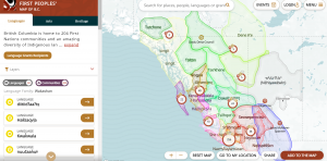
The First Peoples’ Cultural Council has created an interactive map of BC which not only identifies all First Nations within BC, but breaks down language, heritage, and arts for each community. Pronunciation and basic greetings are also apart of the welcome tabs for each nation. Highlighting the over 200 First Nations communities, you can see how many First Nation community members are speaking their language. I visited the geographical location of the Tsleil-Waututh Nation and noticed that 0% of the community can speak the language, Hul’q’umi’num’. Where as 6% of the community can semi-speak and 3.5% are learning. I noticed that the Squamish First nation had similar statistics with the language being semi-spoken by .6 percent of community member but 10% of the community is now learning the language. I began to wonder if technology was aiding in this upsurge of learners?
We have been saying throughout the discussions in class that technology needs to be curated and in control by Indigenous communities. Cathi Charles Wherry, a special advisor to the council states, “One of the most exciting aspects of the map is that the content is created by Indigenous people about Indigenous people […] so we’re not just the subjects, we’re the creators of the content. So this is very unique. It’s not an outside entity looking in at us. It’s from within the communities” (Wherry quoted in Dickson, 2020)
This would be an amazing resource to use in and outside of the classroom and across elementary and post secondary.
https://maps.fpcc.ca/#55.678348649442825/-125.95849609375/3.9960778141674207
Dickson, C. (2021, June 15). New interactive map shares Indigenous arts, language and culture throughout B.C. CBC. https://www.cbc.ca/news/canada/british-columbia/first-peoples-cultural-council-interactive-indigenous-map-1.6067254?cmp=rss