Spatial Analysis of the Effects of the Anomalous Winter of 2014/15 on 157 Ski Resorts Located in Western North America
by KALIM BAHBAHANI and MICHAEL PIDWIRNY
Introduction
The winter of 2014/2015 was one of the warmest in recent history for western North America. The cause of this climate irregularity was the development of extremely warm ocean surface waters (the Blob) over much of the eastern North Pacific Ocean (Di Lorenzo and Mantua, 2016). These high sea surface temperatures influenced weather patterns on the western side of North America producing very mild winter temperatures (Figure 1). At high elevation locations, precipitation that should normally fall as snow, many times came down instead as rain. During the 2014/15 winter season, many ski resorts in western Canada and the United States experienced poor weather conditions. Some ski resorts did not open at all or were forced to close early in January or February because warm temperatures left their runs bare of snow. Here, we analyze winter mean temperature, snowfall, and rainfall data from 157 ski resorts to examine the spatial pattern of this unique climate anomaly.
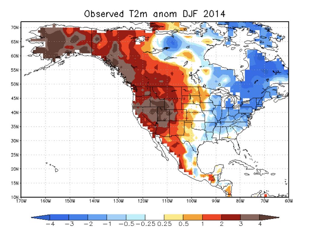
Figure 1. Observed surface temperature anomalies across North America in degrees Celsius during the winter of 2015 (December 2014 and, January and February 2015) relative to average values for the normal period 1981-2010 (Source, NOAA).
Objectives
This research statistically examines the severity of the winter of 2014/15 relative to the 30-year normal period 1981-2010 at 157 ski resorts in western North America. Three climate variables that are directly related to the quality of the ski season were analyzed in this study: winter mean temperature, winter snowfall, and winter rainfall.
Methods
1) We selected 157 major ski resorts located in western North America for this study.
2) Mean temperature, snowfall, and rainfall data for the winter season (combined months of December, January, and February) were generated at mid-elevation of each ski resort for the winter of 2014/15 and the 30 individual years between 1981-2010 using either ClimateBC or ClimateNA. ClimateBC and ClimateNA produce high quality spatially interpolated climate data by statistically downscaling and integrating PRISM monthly data for the period 1961-1990 and historical data from weather stations for the period 1901-2015 (Wang, Hamann, Spittlehouse and Carroll, 2016).
3) For the mean temperature, snowfall and rainfall data, the 30-year normal period of 1981-2010 was used to calculate means and standard deviations. Using these simple descriptive statistics, standardized Z-scores were calculated for the values associated with 2014/15 Blob year relative to 1981-2010.
4) The Z-scores for the three climate variables analyzed for the 157 ski resorts were classified into groups according to the probability of occurrence and then mapped with unique symbols using ArcGIS version 10.3.
Results and Discussion
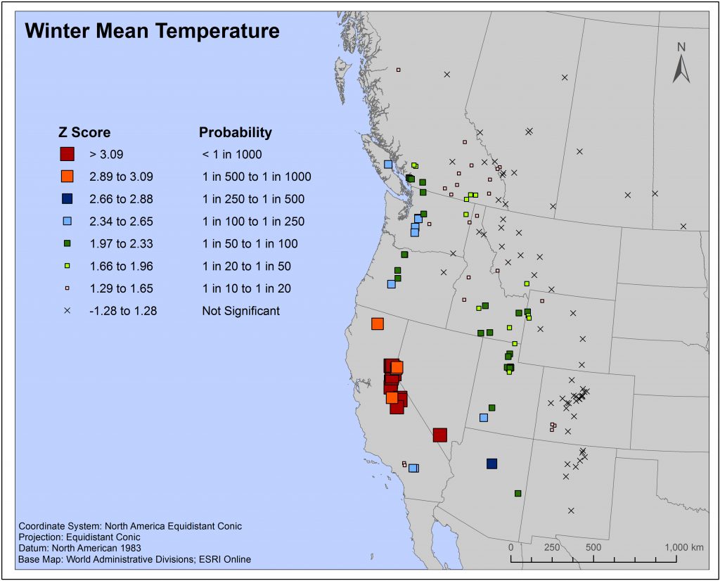
The winter mean temperature map shows that most ski resorts in southern British Columbia, Washington, western Oregon, California, Idaho, Arizona and Utah had an abnormally warm winter season, with the highest Z-scores being mainly located in Sierra Nevada mountains of California and Nevada. A few unusually warm ski resorts occurred in southeastern Montana, northwestern Wyoming and southwestern Colorado. Ski resorts that were generally a greater distance from the Pacific coast were unaffected.
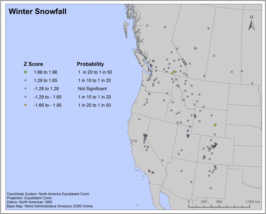
Scattered ski resorts in southern British Columbia, Washington, western Oregon, northern California, southeastern Idaho, and northern Utah had slightly below-normal winter snowfall in 2014/15. A couple resorts in eastern Wyoming and one resort in northwestern Montana had slightly above-normal winter snowfall.
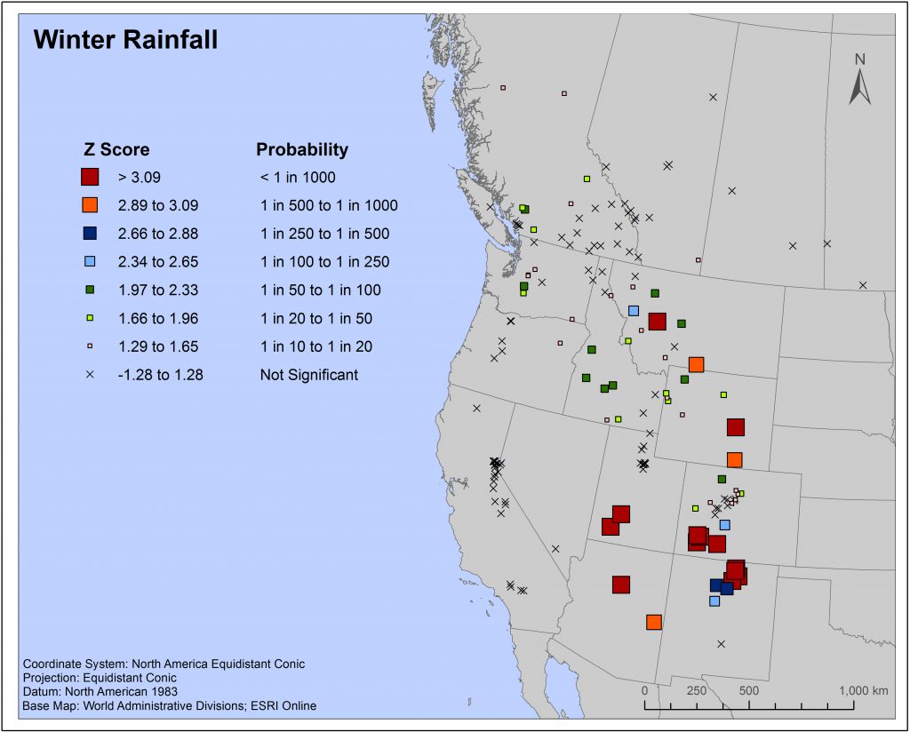
On the winter rainfall map, extremely rainy winter seasons occurred at ski resorts found in Arizona, northern New Mexico, southern Utah, southern Colorado, Wyoming and Montana. Scattered resorts in Idaho, Montana, Wyoming and Colorado had above-normal winter rainfalls but with a lower probability of occurrence. A few ski resorts in coastal Washington and southwestern British Columbia, as well as a couple of resorts in central British Columbia showed slightly higher than average winter rainfall.
The abnormally warm temperatures and frequent rainfall events of the winter of 2014/15 produced a new challenge for ski resort operations in western North America. Historical climate data, that dates back to the beginning of the 20th century, suggests such climate conditions over such a large geographical area have never occurred in the past. In fact, the previous poor ski years of 1976/77 and 1980/81, that also occurred over a large portion of western North America, were caused by lack of snowfall, not warm temperatures. A climatic event similar to the 2014/15 Blob event may occur again sometime in the future. The results of this study identify geographical areas that could be influenced by extremely warm temperatures and unseasonable rainfall events related to such an event.
References
Di Lorenzo, E. and N. Mantua. 2016. Multi-year persistence of the 2014/15 North Pacific marine heatwave. Nature Climate Change (6) doi: 10.1038/NCLIMATE3082
Wang, T., A. Hamann, D. Spittlehouse and C. Carrol 2016. Locally downscaled and spatially customizable climate data for historical and future periods for North America. PLos ONE 11(6) doi:10.1371/journal.pone.0156720.