Reflection
For the past 24 hours I have been spewing fun facts about False Creek and local commercial fishing practices to anyone who will stand still. Growing up in Vancouver, I’ve been to Grandville island hundreds of times, yet I had no concept of local environmental history. This trip was eye opening, and made me see urban shorelines in an entirely new way.
Starting our field trip by looking at photos of what the False Creek area looked like prior to colonial development set the stage for the day. Tanvi showed me one particular photo that stuck with me – a picture of the northern Granville street area as a forest. Seeing this unrecognizable photograph made me realize the staggering pace of development in Vancouver. The forested version of Grandville street resembled scenes of where I have been camping, not a bustling market like today.
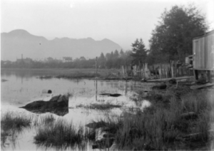
Figure 1. A particularly striking photo: False Creek in the early 1900s.
Source unknown, courtesy of Prof. A Vincent, The University of British Columbia.
Prof. Vincent’s opening remarks: asking us to picture standing in the same spot 200 years ago with forest all around us, permanently re-framed my view of the area. Throughout the rest of the day everything I saw was compared to the pristine forested version of False Creek in my mind.
Meeting with Mark Adams was the perfect culmination of development and reclamation to tie the field trip together. He referenced many of the original natural features of the area that we learnt about throughout the day, and added much more. It was inspiring to hear him walk through his design considerations, and for me to realise how much thought went into Habitat Island.
I have been lucky enough to have bounced around most of the local gulf islands, and it was really interesting to hear Mark point out characteristics of Habitat Island that mirrored local geography. The team designing Habitat Island clearly did a tremendous job, but it was impressive to hear how thoroughly they considered the implications their project would have on the surrounding habitat. For example, they purposely made a very steep sloping shoreline on the northern side of the island to reduce sediments disturbance. Mark explained that as boats drive by and stir-up the sediment, it settles on top of rocks in the area. Sadly, mussels and barnacles are unable to stick to the rocks through the sediment layer. Mark as his team knew that despite their steep slopping shoreline, there was still lots of sediment disturbance in the area. They came up with a smart solution: by using large, round rocks to form the shoreline, there are spaces left on the underside of the big rocks after they have been piled together. Sediment only settles on the top side of rocks, so a pristine habitat for barnacles and mussels is created on the exposed & clean underside of the rocks.
I am heading into a career in product management, so it was interesting to consider the island’s design from a product design point of view. The island was designed for two very different user groups: humans and marine life. I was impressed by the island’s ability to bring animal habitats close to humans, while keeping the habitat relatively protected from human activity. False Creek experiences extremely heavy human traffic, and the fact that Habitat Island has become a viable habitat is incredible. Bringing herring spawn, juvenile salmon, Dungeness crab, and nesting falcons into the heart of this commercial area sets a truly impressive standard for reclamation projects. I am a huge believer in the importance of brining humans in contact with natural environments, and it was quite literally inspiring to see the island’s success.
Coming from a software development background, it was cool to hear Mark discuss the importance of documentation for a park. In software, documentation is paramount. All software projects begin and end with thorough documentation, so that the next team working with the code has a full understanding of the goals and details of the project. Mark explained there is a lack of long term documentation on many reclamation projects to guide future work. Elections change the governing bodies, and consultants often switch firms, so the teams that designed and built the reclamation projects often disband after a few years. Mark expressed special concern over the idea that people will not know why Habitat Island was built, and would be unaware of the amazing reclamation work and important habitats in the area.
As we visited the island with Mark, deterioration to the island was already prevalent. There was widespread erosion, and many plants had been trampled by heavy-footed humans. Mark listed off many maintenance activities needed for the upkeep of the island, but he worries that a lack of stewardship could result in a steady decline of the above-water portion of the island.
On another note, my favourite part of the field trip was meeting Fraser Macdonald, and learning about local commercial fishing practices. I love being at sea. I spend most of my summers at sea in some form: either teaching sailing, sailing for fun, fishing, or zooming around on motor boats. Meeting Fraser was the first time I had the opportunity to hear about someone young-ish making a living for themselves as a fisherman in BC. He provided a very valuable overview of the local fishing industry. As a business student, I am always interested in the economics behind people’s livelihood’s, and it was fascinating to hear about the economics of his fishing company. I never would have guessed the massive inflation of commercial licence prices, nor that private investors would be buying up fishing licences.
Perhaps most valuable of all, it was really interesting to hear Fraser’s sentiment towards various aspects of the fishing industry. Fraser appears to take sustainable fishing very seriously, while other fisherman I have talked to all blame other industries for their dwindling catch. I have heard many fisherman blame loggers encroaching on streams as the main reason why the salmon stocks are dwindling. It was refreshing to hear Fraser acknowledge that many stocks are overfished, and to see him take action by consciously choosing to fish more well-managed stocks.
As an avid prawn fisherman myself, it was great to hear that the Spot Prawn stocks are actively monitored by 3rd party consultants. If I heard Fraser correctly, he mentioned that spot prawn stocks are measured daily over the summer, and the commercial season ends once the 3rd party consultants determine that the stocks are beginning to show signs of over fishing. I was unable to find further information about these spot prawn assessments. The DFO states that prawn and shrimp stocks are relatively stable overall, but this is concerning non-specific. [1]
A list of questions I would love to explore further:
- What portion of commercial fishing licences are owned by investors vs. directly owned by fishermen?
- Fraser Macdonald mentioned a $250 million subsidy for First Nations communities to buy commercial fishing licences, I would be interested in learning more about this program. I can’t seem to find it online after much searching.
- Many questions about the Spot prawn management that Fraser Macdonald referred to:
- What is the name of the 3rd party consultants that monitor the stock? Who are they?
- Fraser mentioned that each prawn fisherman pays a fee to fund the stock assessment. If the stock assessors are funded by the prawn industry, then this presents a concerning opportunity for a bias stock assessment…
- What is the name of the 3rd party consultants that monitor the stock? Who are they?
- Is there a documented plan for the upkeep of Habitat Island moving forward?
- I know it now belongs to the parks board, do they have a publicly available plan?
References:
- Government of Canada, F. (2020, April 21). Integrated fisheries management plan summary: Prawn and shrimp (pandalus spp.) by trap – pacific region, 2020/2021. Retrieved March 07, 2021, from https://www.pac.dfo-mpo.gc.ca/fm-gp/mplans/prawnshrimp-trap-crevette-casier-ifmp-pgip-sm-eng.html