3] In order to address this question you will need to refer to Sparke’s article, “A Map that Roared and an Original Atlas: Canada, Cartography, and the Narration of Nation.” You can easily find this article online. Read the section titled: “Contrapuntal Cartographies” (468 – 470). Write a blog that explains Sparke’s analysis of what Judge McEachern might have meant by this statement: “We’ll call this the map that roared.”
In his article “A Map that Roared and an Original Atlas: Canada, Cartography, and the Narration of Nation” Matthew Sparke outlines the ways in which different physical representations of Canadian geographical history, the map and the Atlas, have communicated information about ownership and sovereignty over the Canadian landscape. Matthew Sparke highlights two case studies in examining this work: The 1997 Gitxsan and Wet’suwet’en case against the government of British Columbia, and the first volume of The Historical Atlas of Canada. Matthew Sparke suggests that both these cases were landmarks in attempting to define a national, unified narrative of land ownership and entitlement to said land, and in placing this definition within a national and historically colonial context.
In the section “Contrapuntal Cartographies” (Sparke 468-470) Sparke outlines the Gitxsan and Wet’suwet’en use of maps and cartography as a form of resistance and protest against a primarily Eurocentric and preferentially colonialist approach. Sparke suggests that both the results of the legal case of Delgamuukw v the Queen and The Historical Atlas of Canada engage in an attempt to create a Canadian “nation-state” identity that encompasses “demographic, economic, cultural, governmental, and social” (468) relationships collectively’ this necessitates a shared vision of land, history, and Canadian future which often does not listen to, or even tolerate, differential and minority viewpoints as legitimate. Sparke highlights the inherent ethnocentrism present in both the case’s proceedings and Judge Mceachern’s decision on it, which was condemned by the United Nations because of Judge McEachern’s discrimination. Sparke looks particularly at the role of cartography, which historically embedded Europeans as the owners and “discoverers” of North America, and in doing so suggests that the ways in which the Gitxsan and Wet’suwet’en nations utilize this same power in challenging this Eurocentric view through a language or modality that is shared between them (the map).
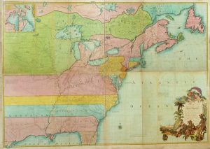
John Mitchell’s rendition of North America prior to the Seven Years War, designed to denote the British as having more territory and therefore a stronger likelihood of success than they had in actuality (Mitchell; Dugre).
In calling the Gitxsan and Wet’suwet’en use of a map that rejects and refuses confinement by existing systems of utilities and systems embedded in colonial establishment a “map that roared,” Judge McEachern recognizes the resistance in this act. This map does not just function as a visual representation of the Indigenous perspective on their land; it is a direct, targeted response to colonial claims of their land in the same language that was used to assert this claim. It is a response in the language of the colonizer that rejects the systems used to confine it and encompass it. In saying it “roared,” the Judge, who would eventually decide against recognizing Indigenous land claims, revealed a recognition of the Indigenous argument as powerful, meaningful, and challenging. It roars in defense of its people, its perspective, and its point: you cannot use a map to lay claim to a land and its history. By recognizing this roar and then dismissing the case, Judge Mceachern could also be seen as inherently recognizing the inability of other cartographies to act as evidence, which relates to its later role in the Delgamuukw v. British Columbia appeal case, which was taken to the Supreme Court of Canada.
In calling this section “Contrapuntal” Sparke also brings forth images of duality, as contrapuntal is traditionally a word used to refer to musical scores comprising two melodic lines. Melodic lines are also usually the most prominent, narrative part of a musical composition in that they are the most identifiable and emotion-laden part of the musical piece. In this context, referring to the ongoing negotiations in perspectives on who “owns” Canada, and which narratives are “correct”, the imagery of two interrelated voices that rely on each other in their engagement seems to mirror the ways in which the Gitxsan and Wet’suwet’en peoples engaged with both the Canadian legal system and its relation to colonial history, and their relationship to the maps and cartographies they used in this case. Challenging the Canadian narrative as it exists cannot occur in a void; the colonial Canadian perspective relies on negating the Indigenous one, just as the Indigenous perspective for this case relies on challenging the existing narrative. Both narratives are independent versions of the events of history, but they rely on each other for context and authority, just as melodies stand alone or operate contrapuntally. Similarly, a map or cartography is embedded with a narrative in that it necessarily operates as a simplified representation of the truth, and in this case, the Gitxsan engage with the cartographic form as a means through which to challenge one narrative (or melody) through another: the form is related, but the story it communicates is different, just as a contrapuntal melody uses a similar form to tell related, but independent, musical stories. In this sense, “The Map that Roared” is related again through sound and story to its functioning as a challenge to existing narratives.
Works Cited
“The Delgamuuk Court Action.” Gitxsan, Gitxsan, 2013, www.gitxsan.com/community/news/the-delgamuukw-court-action. Accessed 19 Feb 2019.
Dugre, Neal. “Maps and the Beginnings of Colonial North America.” Digital Collections for the Classroom, The Newberry, 05 Sep 2017, dcc.newberry.org/collections/maps-and-the-beginnings-of-colonial-north-america. Accessed 19 Feb 2019.
Kurjata, Andrew. “20 years ago, this court case changed the way Canadians understood Indigenous rights.” CBC News British Columbia, CBC News, 11 Dec 2017, www.cbc.ca/news/canada/british-columbia/delgamuukw-vs-british-columbia-20-years-rights-titles-1.4440703. Accessed 19 Feb 2019.
Mitchell, John. “Map of the British and French Dominions.” Map. Scale not given. “Maps and the Beginnings of Colonial North America.” Digital Collections for the Classroom, The Newberry, 05 Sep 2017, dcc.newberry.org/collections/maps-and-the-beginnings-of-colonial-north-america. Accessed 19 Feb 2019.
Sparke, Matthew. “A Map that Roared and an Original Atlas: Canada, Cartography, and the Narration of Nation.” Annals of the Association of American Geographers, vol. 88, no. 3, 2010, pp. 463-495
“What is Counterpoint?” Music of Yesterday, 2019, musicofyesterday.com/historical-music-theory/what-is-counterpoint/. Accessed 19 Feb 2019.