Studying temporal climatic variability at representative locations for BEC variants is a key part of my research methodology. The premise of this approach is that BEC variants aren’t entities in themselves, but instead are ecologically relevant subdivisions of continuous climatic gradients across the landscape. The implications of this premise is that BEC variants are better characterized in terms of core conditions than in terms of boundary locations, and also that temporal climatic variation at a representative location is more ecologically relevant than spatial climatic variation across the geographic extent of the BEC variant.
Representative locations need to meet the following criteria to be effective:
- They need to be near the centroid of the spatial climatic variation of the BEC variant;
- They should be able to represent the temporal climatic variability of the BEC variant. If the BEC variant spans different climatic regions, more than one centroid surrogate may be required;
- They shouldn’t be located at the geographic extremes of their BEC variants; and
- The relative geographic positions of representative locations should make sense in terms of regional climatic gradients.
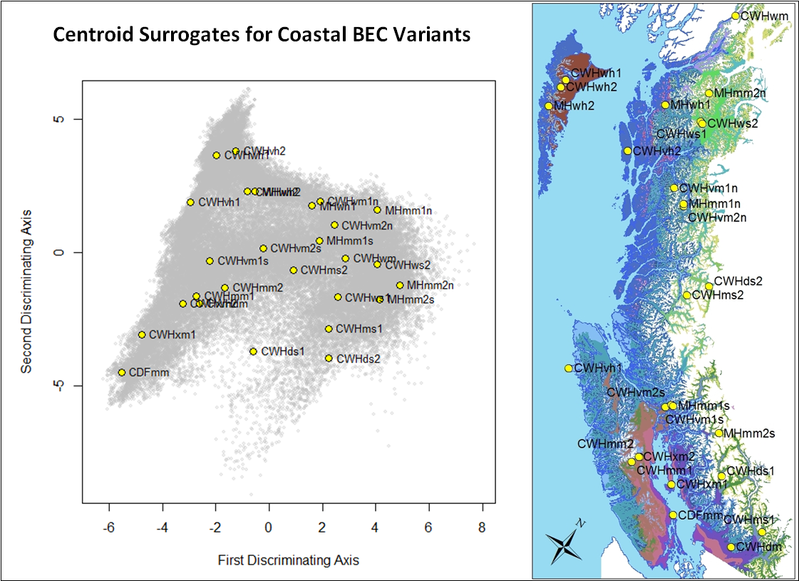
A simple way to identify representative locations is to identify the multivariate centroid of the spatial variation in climatic normals for each BEC variant, and then find a geographic location that is at or near to this centroid. I call this location the “centroid surrogate” of the BEC variant. In the previous post, I found preliminary centroid surrogates for the BEC variants of the BC coast. However, I noted several problems:
- Some BEC variants (e.g. the MHmm2) span the entire coast. This is problematic because the north coast and south coast have different patterns of temporal climatic variability. BEC variants with very large geographic extents need to be subdivided for climate change analysis.
- Several centroid surrogates were located at geographical (e.g. CWHds1, ms1, vh1) and elevational (CWHdm) extremes of their BEC variants.
- Standardized euclidian distance was used instead of mahalanobis distance. Mahalonobis distance is likely preferable due to the correlations between climate variables.
In this post, I modify the methodology to address each of these problems and find centroid surrogates that adequately meet the criteria for representative locations.
Subdividing very large BEC variants
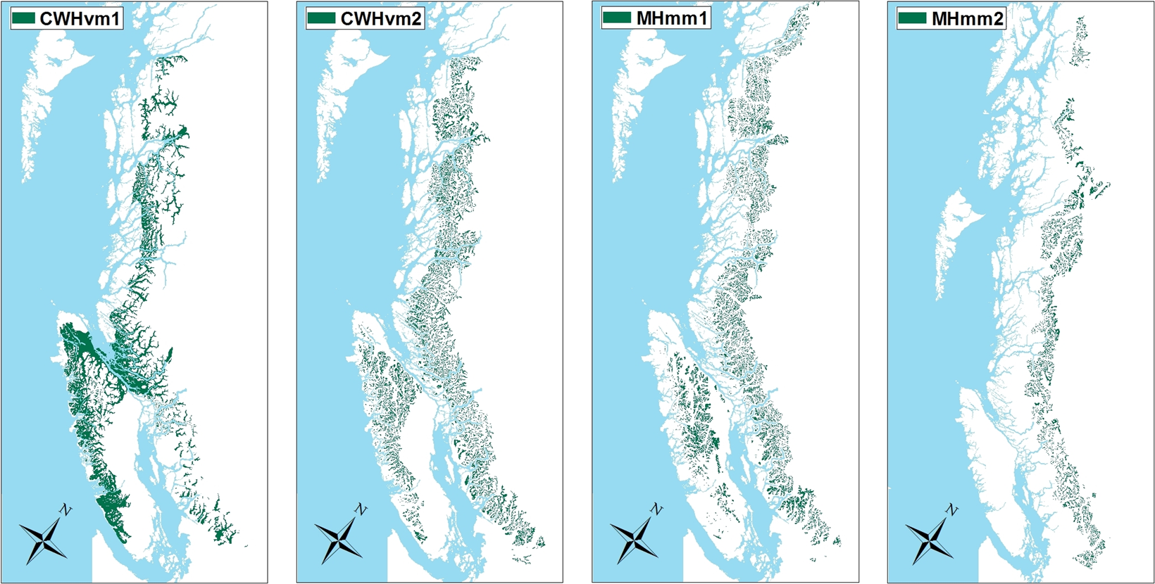
Figure 1: BEC variants with large geographic distributions requiring subdivision for the purposes of climate change analysis.
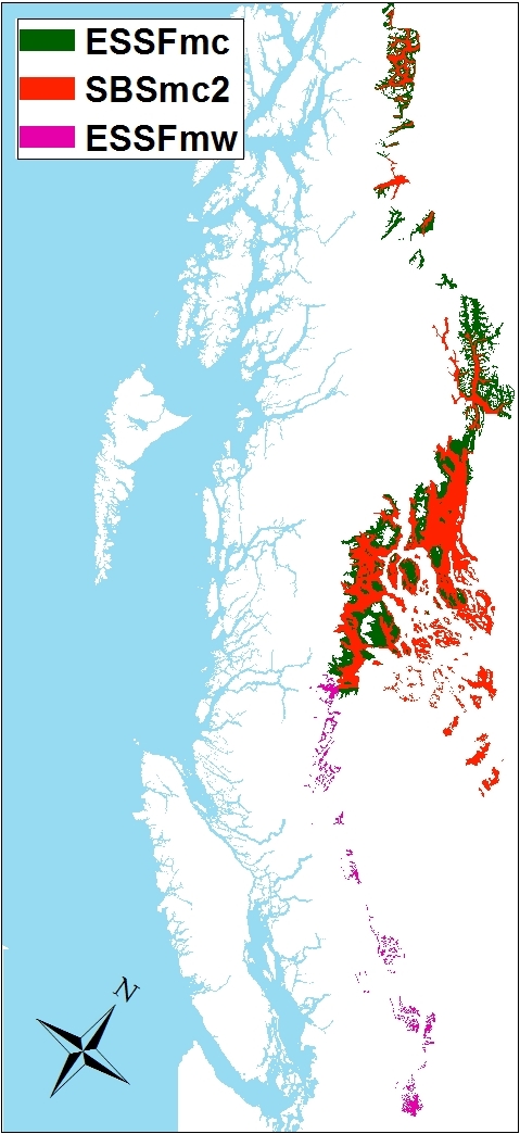
Figure 2: interior BEC variants with moderate geographic distributions that were not subdivided.
I conducted a map review of all BEC variants in British Columbia (excluding alpine and parkland variants). the only variants that clearly span more than one climatic region are the previously identified coastal variants: the CWHvm1/2 and MHmm1/2 (Figure 1). Three variants in the interior have moderately large geographic distributions (SBSmc2, ESSFmc, ESSFmw), but were not subdivided because the majority of each of these variants is located in one climatic region (Figure 2). The four coastal variants were subdivided as follows:
- CWHvm: area within the Coastal Gap Ecoregion denoted as northern subunits (CWHvm1n, vm2n). Rest of area denoted as southern subunits (CWHvm1s, vm2s).
- MHmm: northern (suffix “n”) and southern (“s”) subunits divided by 52o Latitude.
Mahalanobis distance: Euclidian distance on a subset of principal components
Climatic distance was measured using Euclidian distance on the first 9 of 15 principal components of the annual 1961-1990 climatic normals for a 1600m grid of the entire area of BC. These PCs represent 99.9% of the variance in the data. This high threshold was chosen because the PCA was done over the entire area of BC, and meaningful climatic variation of individual BEC variants may occur in lower-eigenvalue PCs.
Geoclimatic centroid surrogates
As noted in the previous post, centroid surrogates based purely on climatic variation can occur at geographic extremes of some BEC variants, which is undesirable. Conversely, locations near the geographic centre of BEC variants may not be sufficiently near the climatic centroid to be representative of the BEC variant. These issues are illustrated in Figure 3. To solve this problem, I limited the candidate grid points to those within one standard deviation of the latitude, longitude, and elevation means of each BEC variant. I called this a “geoclimatic” approach to finding centroid surrogates.
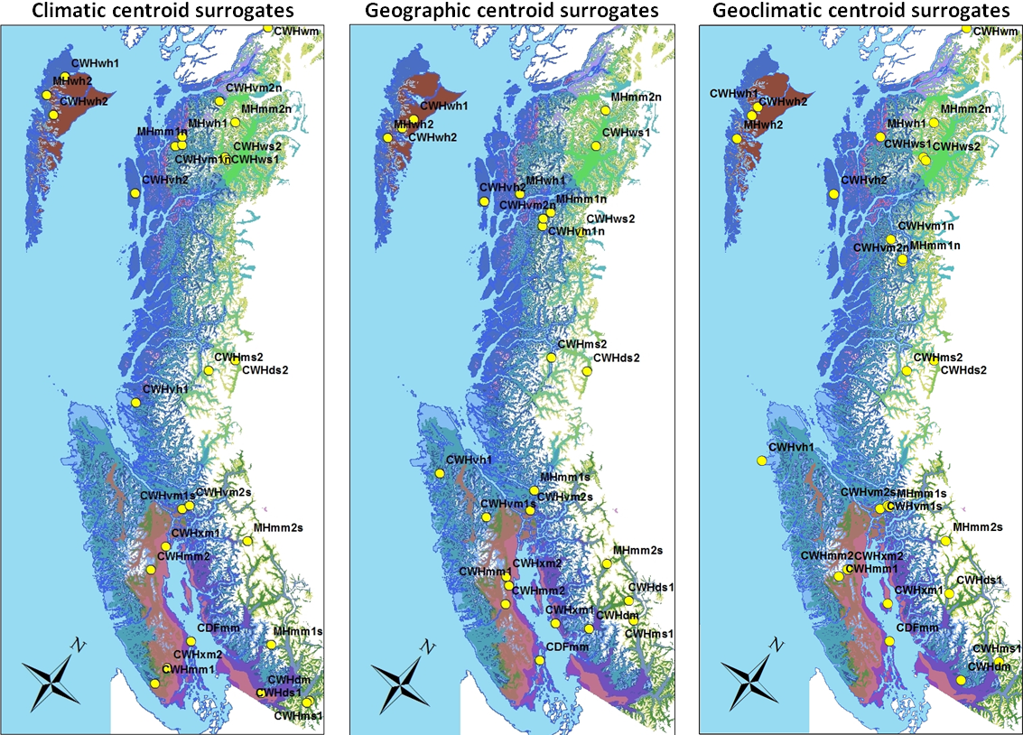
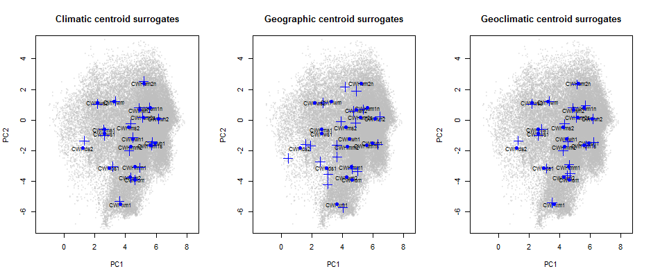
Figure 3: comparison of climatic, geographic, and geoclimatic centroid surrogates, in the first two principal components of 1961-1990 annual climate normal variation across British Columbia.
Centroid surrogates were generated for all BEC variants in British Columbia. For simplicity, results are shown here only for the coastal region. The geoclimatic centroid surrogates for the coast adequately meet the criteria for representative locations. specifically, the following attributes are notable:
- The relative locations of centroid surrogates intuitively make sense and all appear to be within the geographic and climatic cores of the BEC variants. The only possible exception is the centroid surrogate for the CWHvh1; the outer coast of the brooks peninsula may be unrepresentative.
- Centroid surrogates are well distributed in climate space (especially in 3D), but are somewhat clustered in map space. With the exception of the CWHms2 and ds2, there are no centroid surrogates on the central coast. This creates a geographic separation between south coast and north coast regions. There are also smaller-scale clusters of BEC variants, most notably: the CWHvm1s/vm2s/MHmm1s; the CWHvm1n/vm2n/MHmm1n; and the CWHxm2/mm1/mm2. These clusters may be advantageous for some purposes, but they may also create artifacts in analyses based on interpolated climatic time series. The geographical clustering of centroid surrogates must be kept in mind for interpretation of other analyses.
Overall, the geoclimatic centroid surrogates appear to be an acceptable result, and will be used as the basis for the next stages of my research.