The Garibaldi at Squamish is a proposed year-round mountain resort mega-project located between Vancouver, BC and Whistler, BC that has been subject to a great deal of contention since its initial proposal was submitted by the proponent in 1997. In order to assist in performing an effective Environmental Impact Assessment (EIA) on the proposed project to asses the environmental, social, and economic impacts of it, I performed a thorough analysis on the proposed project area. To determine some of the key areas that need to be protected for this project in order to minimize effects on the surrounding environment, I mapped out areas of old growth forest, ungulate habitat areas, and riparian management zones around rivers and streams, as well as the locations of existing rivers and roads. All areas within the proposed project zone were either classified as being above or below 600 meters in elevation, in order to predict whether or not there will be enough snow to open ski runs.
My analysis found that a relatively large proportion of the area for the proposed Garibaldi at Squamish resort project was considered to be protected land, meaning that it consisted of old growth forest and/or ungulate habitat and/or riparian management zones around rivers and streams. Riparian management zones around rivers and streams made up 28 percent of the total protected area, old growth forests made up 7 percent ,and ungulate habitat areas made up 8 percent. The total protected area from all three variables covered nearly 40 percent of the total proposed area for the project. This indicates that out of the total area of the project, in order to protect the present day environment, only 60 percent of it can undergo development. Additionally, as seen in Figure 1, not all of the non-protected land in the proposed area is at an elevation of 600 or more meters, meaning that there will likely not be enough snow for people to ski. Considering the increasingly severe effects of climate change, this predetermined snow-line elevation is only going to increase in the future, meaning that a few decades from now the majority of the area may not even get any snow.
That said, the data used in this analysis may not be the most accurate and up-to-date information, and is likely to continue changing in the coming years. The projected snow-line elevation of 600 meters, as shown by the snow-line contour in Figure 2, is just an estimate, and changes in climate due to El Nino and La Nina events, as well as climate change are most likely going to effect this value, as well as whether or not an area receives a lot of snowfall. Further analyses can determine how other effects of climate change, such as temperature changes and changes in animal migration patterns will impact and be impacted by the development of The Garibaldi at Squamish. Additionally, the proximity of this all-season resort to both Vancouver and Whistler should be considered both environmentally and economically, in order to determine if there is an actual need for this project.
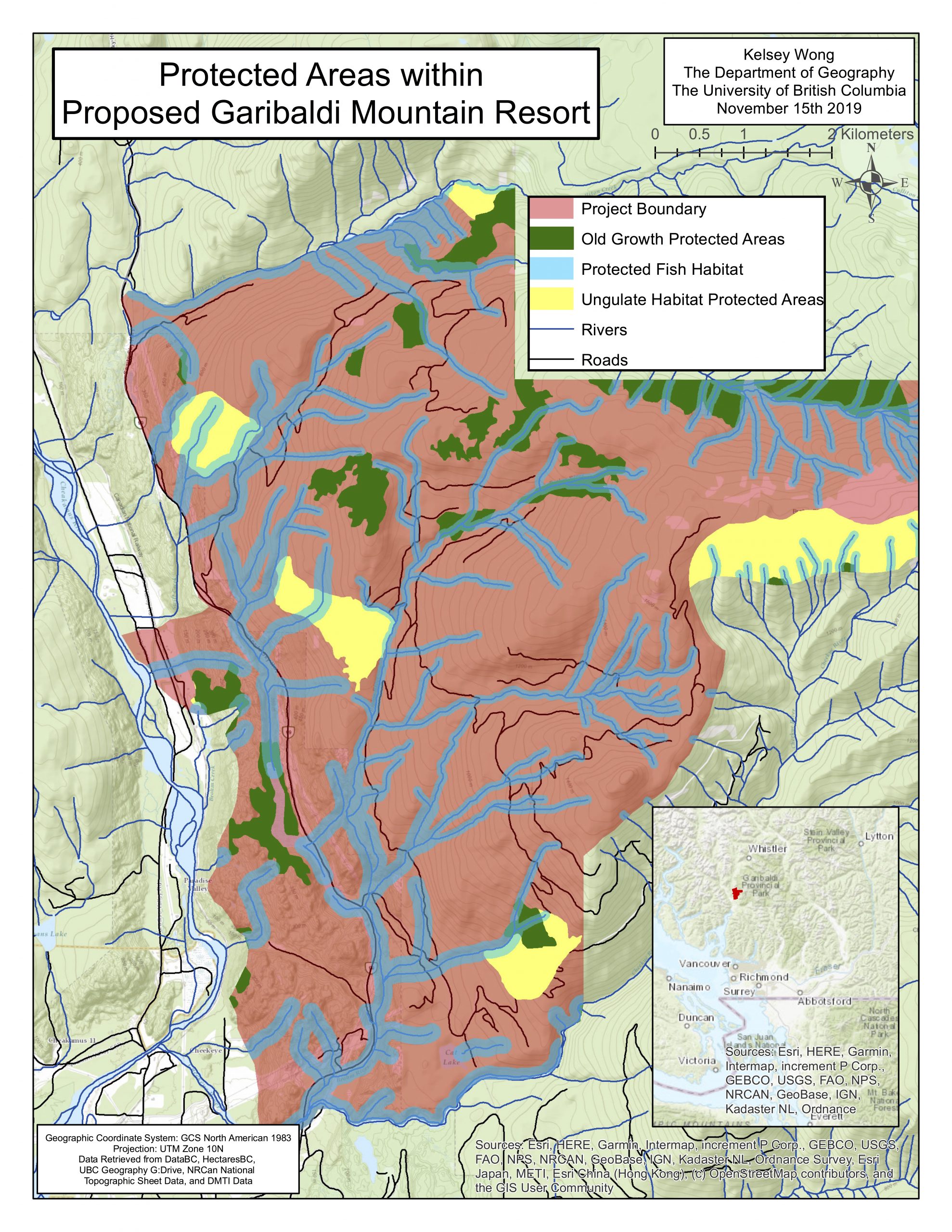
Figure 1. This map shows the proposed project area for a new year-round mountain resort called The Garibaldi at Squamish, located between Vancouver, BC and Whistler, BC. Protected areas, including old growth forests, ungulate habitat, and fish habitat that fall within the proposed project area are also shown, as well as currently existing local roads and rivers. The inset map shows the project’s location (in red) within the province of BC.
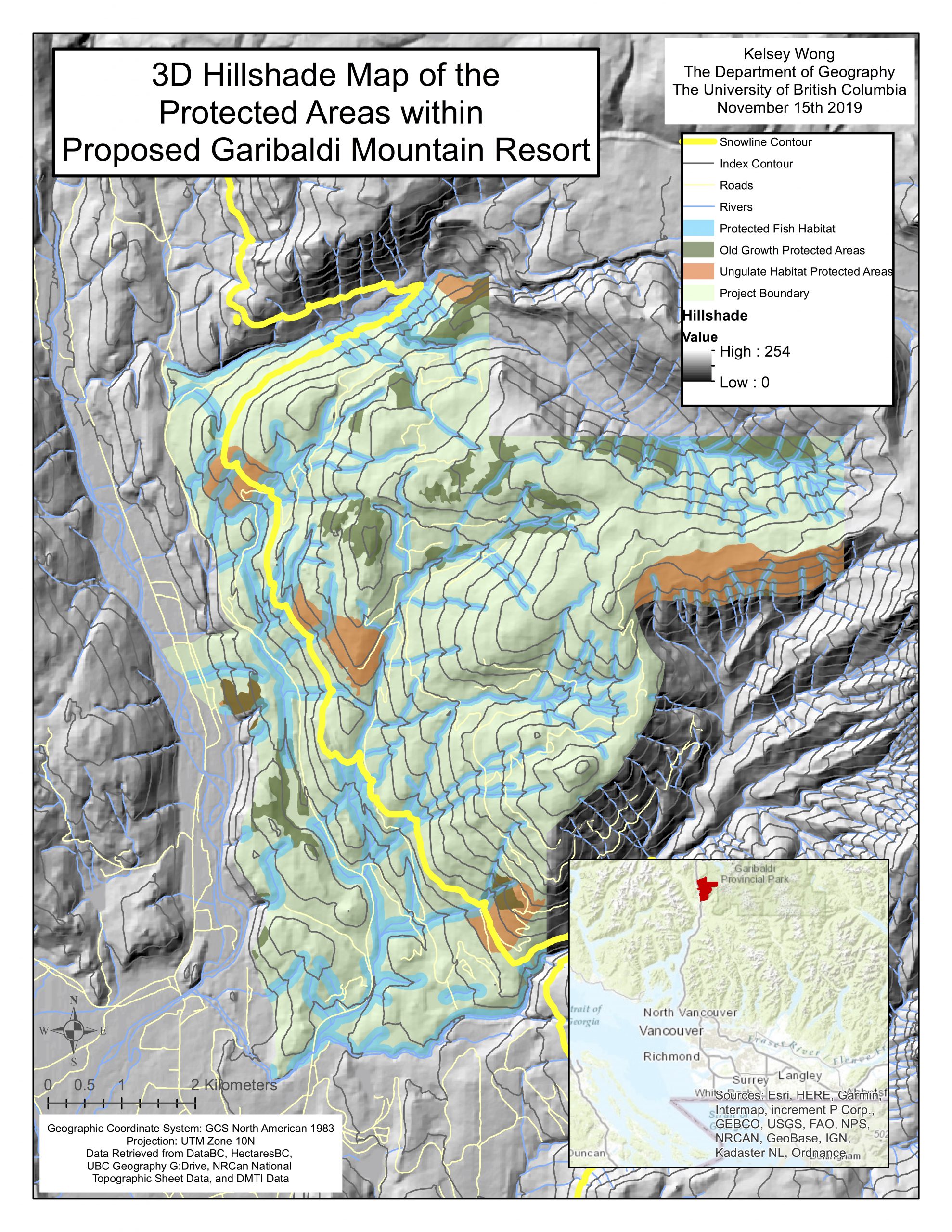
Figure 2. This 3D hill-shade map shows the proposed project area for a new year-round mountain resort called The Garibaldi at Squamish, located between Vancouver, BC and Whistler, BC. Protected areas, including old growth forests, ungulate habitat, and fish habitat that fall within the proposed project area are also shown, as well as currently existing local roads and rivers. The snow-line contour (yellow line) shows the contour that represents an elevation of 600 meters, the predicted minimum elevation for adequate snowfall for ski runs to open. The index contour lines occur at 100 meter intervals. The inset map shows the project’s location (in red) within the province of BC.