Maps
Layers for Map 1 – Suitability Map
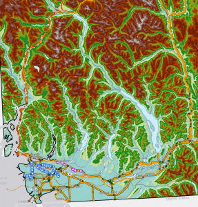
Map 1 before Raster Calculator – PDF
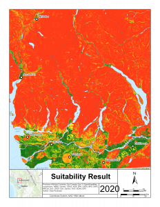
Suitability Result (Map 1 – PDF)
Summary Layers of Map 2 – Social Considerations
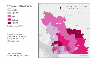
Low Income Layer 1 (Map – SocM1 – PDF)
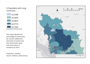
Long Commute Layer 2 Map – SocM2 – PDF
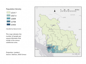
Population Density Layer 3 (Map – SocM3 – PDF)
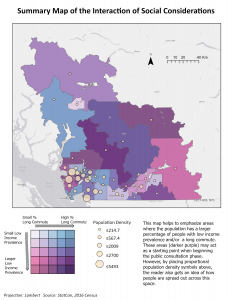
Social Considerations Summary (Map 2 – SocM4 – PDF)
Results
Project Summary
For our project, we examined potential routes from Chilliwack to Whistler based on topographical and environmental considerations including elevation, slope, species at risk, provincial park land, as well as sensitive water sheds (Map 1).We also created a summary map on social considerations (Map 2 – SocM4) based on population density (Map – Soc M3), income (Map – Soc M2), and commuter times (Map – SocM1). We looked at these factors in order to determine the need for a commuter train connecting different parts of the lower mainland and Sea to Sky.
As we can see from the Suitability Result Map 1 above, as well as from our knowledge of the region gained from research, the Allowable Grade Corridors Map 4, and the Possible Restraints Map 6, as well as the hope to service areas of lower income and higher commute times in Squamish (Map 2 – Soc4), there are two preferable routes in the Coastal Region. The two routes that would be the most suitable can be seen below in the Potential Route Map 3 as well as in the Allowable Grade Corridor Map 4 and the Possible Restraints Map 6 below as Route A & C.
The first corridor, Route A, extends from Chilliwack along highway and train beds to the North Shore (Transportation Corridors Map 5 below), through West Vancouver and then up the Sea to Sky Highway through Squamish to Whistler (left route in the Potential Route Map 3 below). The second corridor that we considered, Route B, would take the middle trajectory in the Potential Route Map 3, but considering the high degree of slope (Map 5) as well as the sensitive water shed habitat (Map 6), this route was determined to be an ill fit for the proposed project. The other potential corridor, Route C, would take the same trajectory as the first two routes but differs in that it would divert through to Deep Cove up Indian Arm then along logging roads to Squamish (righthand route in the Potential Route Map 3).
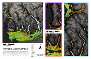
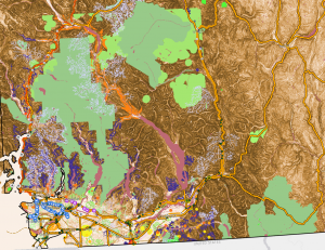
Allowable Grade Corridors (Map 4 PDF)
Lower Mainland Segment of the High Speed Rail (Map 5)
Building the high speed rail from Chilliwack to the North Shore and then to Whistler along existing highway and train beds with relevant stops at major transit hubs including Skytrain terminals and bus depots is the most rational route to take as is illustrated in Map 5 below (Mountain Valley Express, 2020). Using existing infrastructure would reduce the cost to build the rail, would marginally increase risk to at risk species as no new land would be used on this section of rail, and getting approvals through a BC and Federal Environmental Assessment process should be similar to other infrastructure projects such as highway expansion (Buckingham & Doyle, 2009). Consultations with impacted communities including First Nation groups and communities adjacent to the proposed rail way line would also need to be included in a proposal before a rail route could be built (Impact Assessment, 2020).
![]()
Transportation Corridors – Lower Mainland Route (Map 5 PDF)
Sea to Sky Segment of the High Speed Rail (Route A – Map 4)
Where the analysis becomes more intricate is through picking a route from the lower mainland to Squamish as the region has steep elevation changes, high degrees of slope, many provincial parks and protected water sheds (see Figure 1 below). This area is also home to a variety of potentially impacted at risk species (Map 6), climatic hazards such as freezing temperatures and high precipitation both in rain and snow fall, as well as narrow areas in which there is minimal space in which to incorporate a high speed rail line (Blais-Stevens & Hungr, 2008) (Map 1).
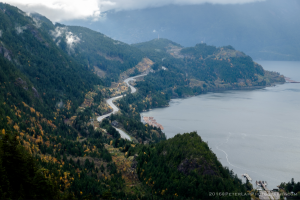
Sea to Sky Highway (Lam, 2016)
The Sea to Sky Section of route one is an area of intense natural beauty, rugged landscapes including high slope and elevation, as well as communities which closely straddle the highway including Lions Bay and Squamish with communities of high commuter traffic (Buckingham & Doyle, 2009), (Map – SocM4 & Map 6). This area also suffers from extreme weather patterns as well as geological hazards such as flooding, freezing and thawing which can cause rock and mud slides, as well as risks from earthquakes (Blais-Stevens & Hungr, 2008).
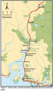
Figure 1. Provincial Parks and Communities in the Sea to Sky Corridor PDF
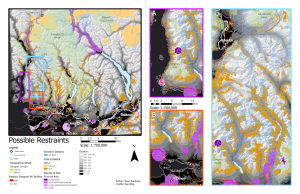
There are also several at risk species (Possible Restraints Map 6 below) which have narrow habitat ranges in this area, including the endangered Red Legged Frog (Figure 2), Arbutus trees habitat (Figure 3), fragile fish spawning habitat, Bald Eagle nesting sites, as well as a variety of provincial parks as can be seen in Figure 1 above (Government of British Columbia, 2020) & (Buckingham & Doyle, 2009) and in Map 6 below. These issues can be mitigated as has been the case with the expansion of Highway 99 prior to the 2010 Olympics. For example, by using improved crossing structures for fish, restrictions on clearing vegetation during breeding seasons, monitoring of bird nests using cameras and video, water quality management, as well as park improvement projects to mitigate the impact of encroachment onto provincial park areas, the rail way proponents could reduce or mitigate impacts from the project on wildlife while providing services to surrounding communities (Buckingham & Doyle, 2009).
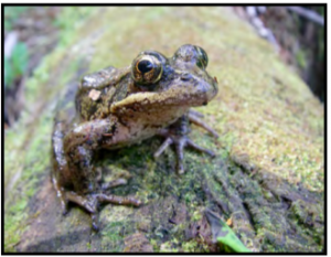
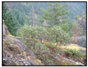
Figure 2. Red Legged Frog Figure 3. Arbutus Habitat
The benefits of taking Route A are that there are already pre-existing rail beds, which although may not be able to accommodate the highest speeds from West Vancouver to Squamish due to the winding nature of the rail caused by topography and terrain characteristics, this corridor has been used in the past for a commuter train as well as currently for a tourist train via the Rocky Mountain Express and for freight (Map 5). As such, Route A could potentially be a less money and time intensive route to build as less modifications would have to be made to the landscape in order to make the route suitable for a higher speed commuter train. Route A could accommodate a high speed commuter train at slower speeds in the Horseshoe Bay to Squamish stretch with time gained on the Chilliwack to Vancouver and the Squamish to Whistler portions of the route. Although according to the Suitability Map, part of Route C would be the preferable route as the area in North Vancouver to the beginning of Indian Arm has a higher suitability than West Van to Squamish (Map 1).
Indian Arm to Squamish (Route C – Map 4)
Route C would take the route from the North Shore up Indian Arm through to Iron Bay then along pre-existing logging routes to Squamish. This route has the benefits of resting in areas of lower slope (Map 1, Map 4) as well as avoiding larger communities such as West Vancouver and Lions Bay which are already well serviced via bus transit systems (BC Transit, 2015). These communities also have a history of advocating against expansion, which has previously led to court cases and arrests. Most recently in response to the 2010 Winter Olympics Highway 99 expansion because the project was anticipated by protesters to have a negative impact on housing prices as well as have negative environmental consequences (Hernandez, 2020). Although Deep Cove also has a history of advocating against development as was seen in the proposed bridge between Deep Cove and Coquitlam (Jung, 2019). But since this time, there has been exponential increase in urban density and commuter traffic in both North Vancouver and Squamish, and as such, perhaps a high speed rail would have a better public and municipal government reception than past proposed projects (Hernandez, 2020).
Route C, would have the disadvantage of having a higher cost to construct as there is little to no infrastructure past Indian Arm and the cost of creating and maintaining a rail in such a remote location would be higher than if done along existing highway such as in Route A (Map 1). Route C would also intersect provincial parks including Seymour Provincial Park, Say Nuth Khaw Yum Provincial Park, Buntzen Lake, and Balcarra Regional Park, (Figure 1) and as such, special concessions would have to be made in the Environmental Assessment Processes in order to allow a rail line to be built (Buckingham & Doyle, 2009). Although Route C has the advantage of impacting less critical habitat, less species at risk as well as less sensitive streams than Route A and B (Map 6).
Conclusion
The high costs of building a rail line as well as the challenging topography of the Sea to Sky area makes building a high speed rail line a challenging proposition (Crosby, 2019). With increasing commuter and tourist traffic along Highway 99, traffic accidents and higher carbon emissions have increased, as such, a green commuting solution needs to be found for this region (Crosby, 2019). A high speed rail would help to decrease traffic accidents, reduce carbon emissions, would cause a housing boom in the areas further away from Vancouver and would increase the work life balance for many commuters by reducing travel time and creating cheaper and more accessible housing opportunities further away from places of work (Mountain Valley Express, 2020). Day tourist traffic would increase to Whistler as Whistler would become more accessible, which would increase the local tourist economy. Although, housing prices in Squamish, Whistler, and Chilliwack may increase, which may have a negative impact on local communities in the form of higher property values, higher rental costs and proportionately higher taxes (Hernandez, 2020).
Through our analysis we have found that the issue of implementing a high speed rail through the lower mainland up to Whistler may be more challenging due to the need for straighter rail lines to accommodate higher speeds. As such, perhaps extending the Skytrain or West Coast express to Chilliwack, North Vancouver and Whistler along Route A, would fulfill the need for a commuter train to reduce traffic and carbon emissions while respecting the challenging topography and existing freight right of way. As an alternative, perhaps the High Speed Train should be completed in stages, with the first section of the high speed train to be built from Chilliwack to Vancouver, as more people would benefit from the portion of the route due to decreased commuter times (Map 2).