Uncategorized

2021/22 Winter Forecast for Western Canada’s Ski Resorts

by MICHAEL PIDWIRNY

Introduction

During the winter months of December, January, and February, the climate of the northwest USA and southern British Columbia is defined by cooling temperatures and an increase in precipitation. Temperatures cool mainly because of the reduction in heat energy supplied by the Sun. During these months, the intensity of the solar radiant energy declines because of lower Sun angles and a shortening of day length. Figure 1 describes the average near-surface temperature (2 meters above ground level) for the winter season. Temperatures along the west coast are moderated by the stored heat energy found in the surface waters of the Pacific Ocean.
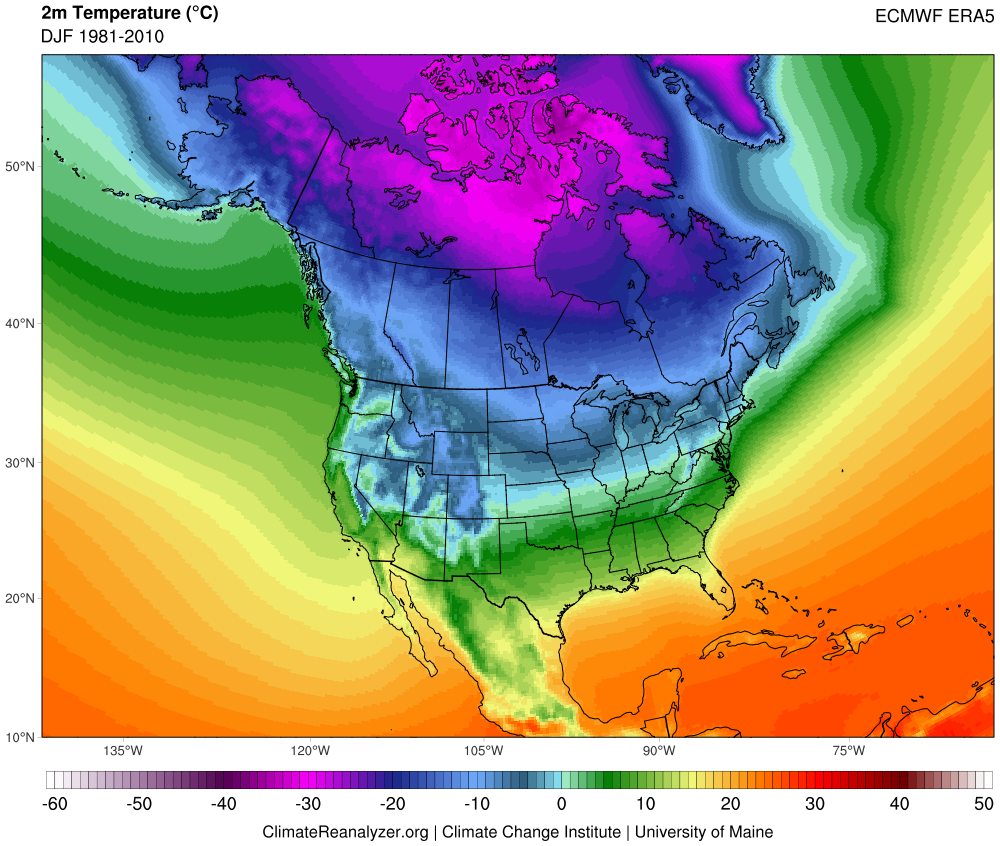

Figure 1. Average winter near-surface mean temperature (°C) for the North American continent and adjacent oceans for the period 1981-2010. Source: Climate Reanalyzer – https://climatereanalyzer.org.

Figure 2 describes the typical patterns of winter precipitation for North America. High amounts of precipitation occur along much of the west coast because of the interaction between mid-latitude cyclones and orographic uplift. During winter, mid-latitude cyclones often originate in the northeastern Pacific Ocean and then move in an easterly direction. Orographic enhancement of the quantity of precipitation falling from these storm systems occurs because of the presence of mountains found running from Alaska to California. Central North America is relatively dry compared to the west coast because most of the precipitable water held in the clouds of the mid-latitude cyclones previously precipitated out and the cold continental air masses frequently found here hold little moisture.
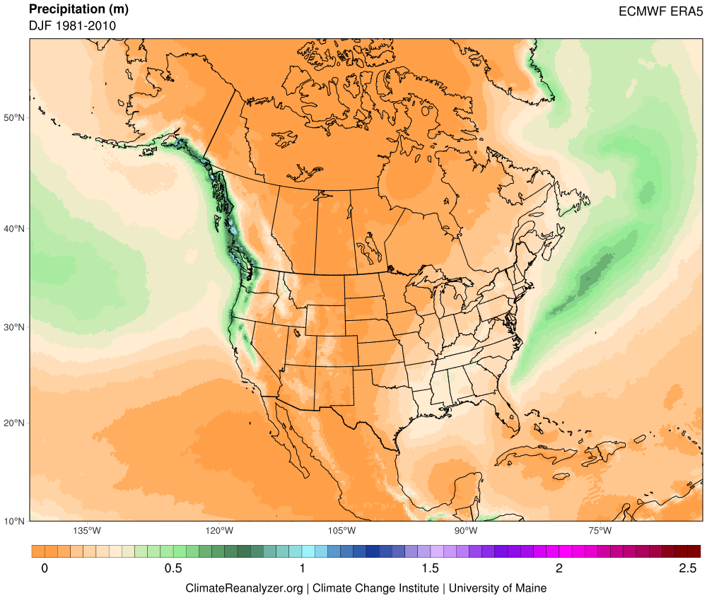

Figure 2. Average winter precipitation over the North American continent and the adjacent oceans for the period 1981-2010. Source: Climate Reanalyzer – https://climatereanalyzer.org.

Variation in year-to-year winter weather of the northwest USA and southern British Columbia is strongly influenced by several large-scale cyclic climate phenomena which modify large-scale atmospheric circulation and sea surface temperatures in the Pacific Ocean. Further, these climate factors tend to have a significant impact on temperature and precipitation trends during the winter months over southern British Columbia and Washington state. Seesawing on a time scale of a few years are El Niño and La Niña events located along teh tropical Pacific Ocean. El Niño – usually brings warmer than average winters and below-average precipitation to this area of the Pacific Northwest. La Niña – is often associated with cold winters with average to above-normal precipitation. Generally, the effects of significant El Niño and La Niña are limited to one or maybe two consecutive winter seasons. Operating on a much longer timescale of one to three decades is another cyclic climate factor of importance known as the Pacific Decadal Oscillation. The Pacific Decadal Oscillation alternates between a warm or a cold state and these states seem to amplify the climatic effects of co-occurring El Niño and La Niña events, respectively.

El Niño

El Niño is the name given to the cyclical development of warm ocean surface waters on the east side of the Pacific Ocean at the equator. This climate event usually occurs around Christmas and usually lasts for a few weeks (weak) to a few months (strong). El Niño is created by a reduction in the speed of the Trade Winds right along the equator which results in a shift in atmospheric circulation and pressure patterns in this region of the planet (Figure 3). Sometimes an extremely warm El Niño can develop and last for more than a year. Since 1935, significant El Niño events have developed in 1958, 1966, 1978, 1983, 1987, 1990, 1992, 1993, 1998, 2005, 2010, and 2016. Figure 4 shows the general global patterns of winter surface temperature warming and cooling associated with El Niño.
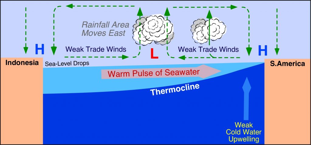

Figure 3. Cross-section along the Pacific Ocean at the equator during an El Niño event. Notice associated atmospheric circulation patterns and direction of warm seawater pulse in the ocean.
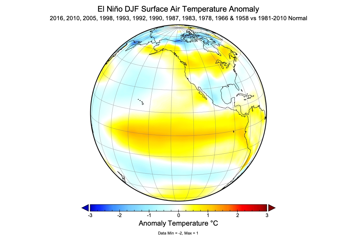

Figure 4. December to February near-surface temperature anomaly based on the average of twelve El Niño years relative to the 1981-2010 normal average.

La Niña

La Niña is the name given to the cyclical development of cold ocean surface waters on the east side of the Pacific Ocean at the equator. Similar to El Niño, a La Niña climate event usually occurs around Christmas and normally lasts for a few weeks (weak) to a few months (strong). La Niña is created by an increase in the speed of the Trade Winds along the equator which results in a shift in atmospheric circulation and pressure patterns in this region of the planet (Figure 5). Sometimes an extremely cold La Niña can develop and last for more than a year. Since 1935, significant La Niñas have occurred in 1950, 1956, 1967, 1971, 1974, 1976, 1999, 2008, 2011, and 2021. Figure 6 shows the general global patterns of winter surface temperature cooling and warming associated with La Niña.
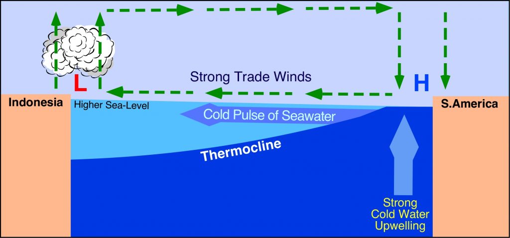

Figure 5. Cross-section along the Pacific Ocean at the equator during a La Niña event. Notice associated atmospheric circulation patterns and direction of cold seawater pulse in the ocean.
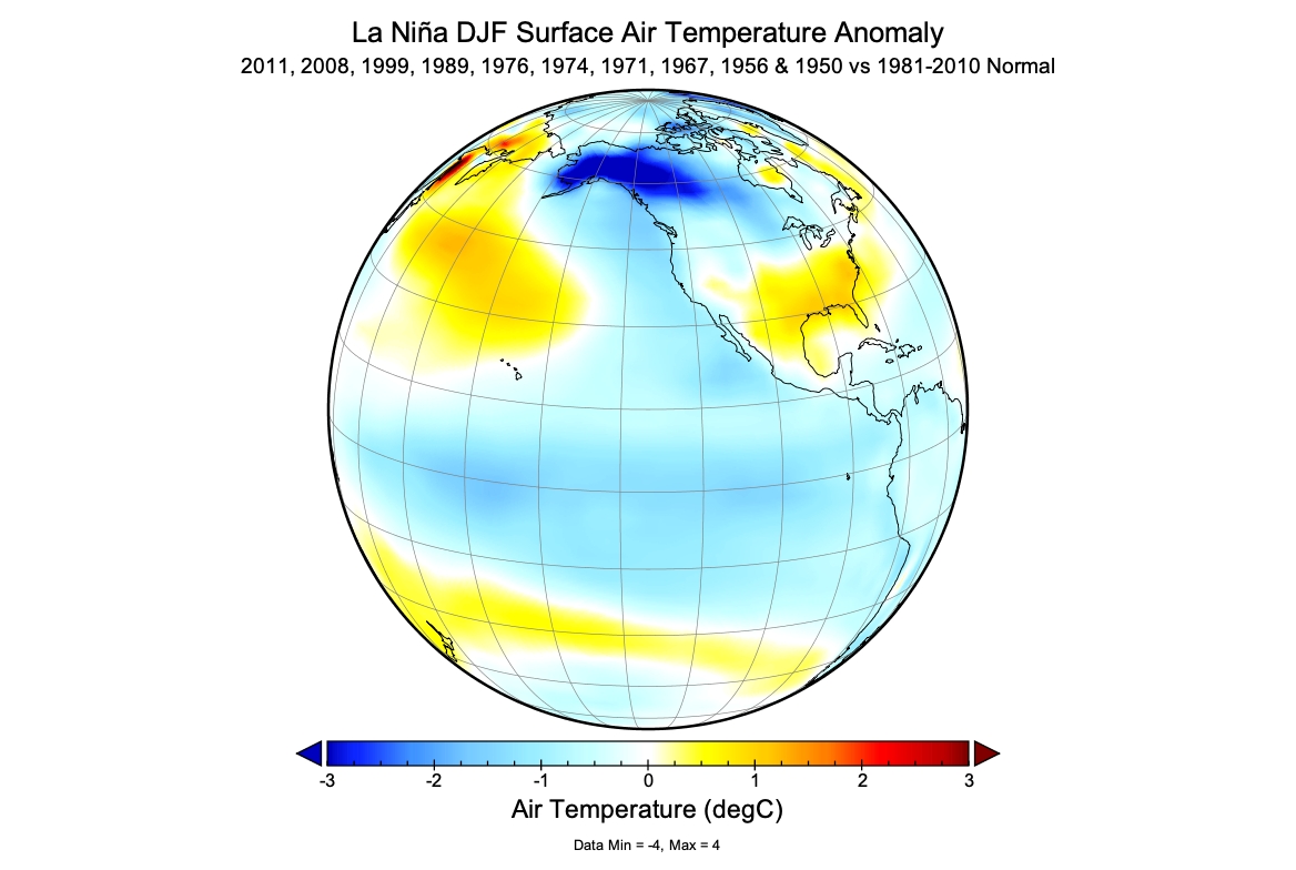

Figure 6. December to February near-surface temperature anomaly based on the average of ten La Niña years relative to the 1981-2010 normal average.

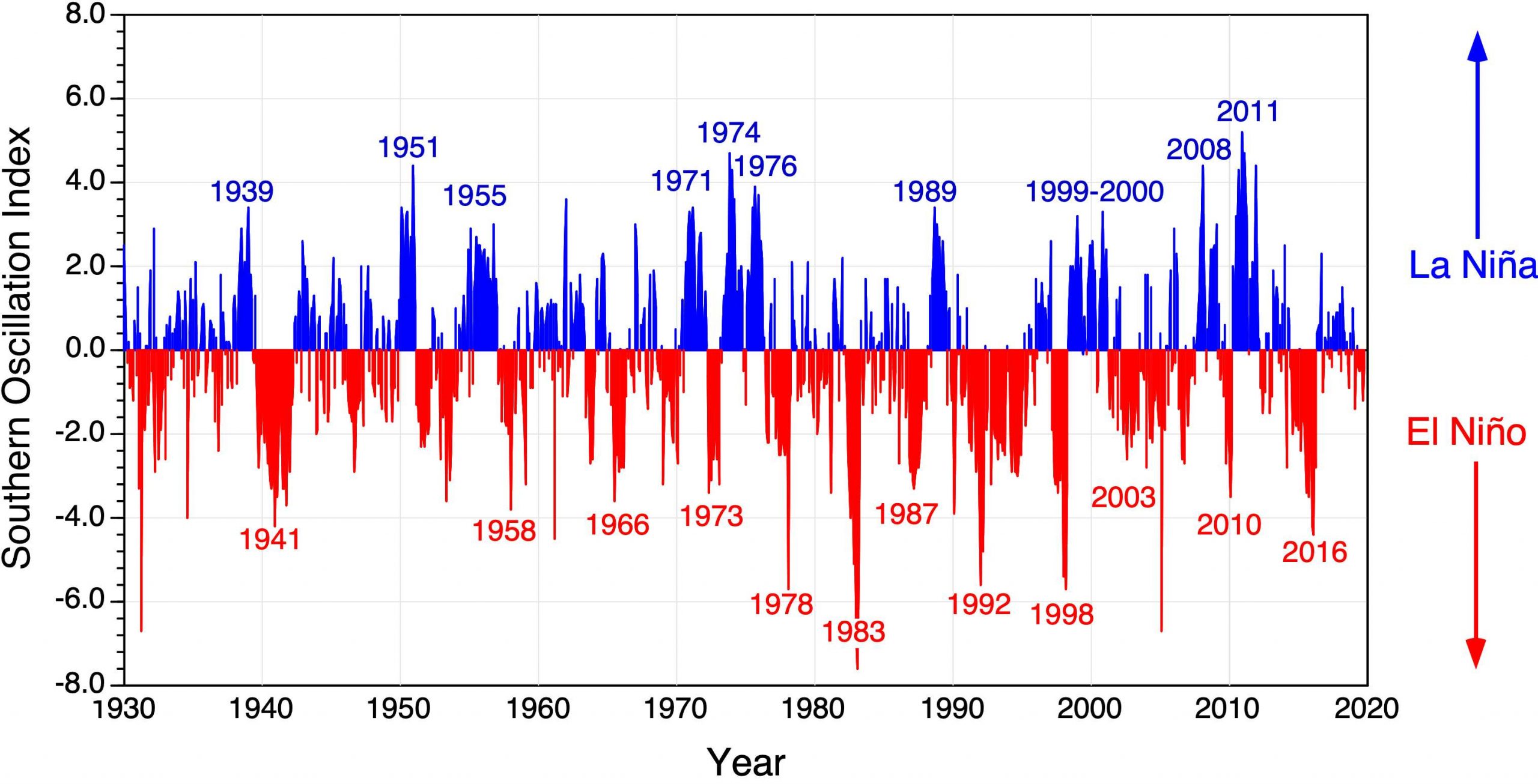
Figure 7 shows the relative strength of El Niño and La Niña events from 1930 to 2021 according to the Southern Oscillation Index (SOI). On this figure, negative values indicate El Niño conditions with lower values suggesting stronger events. High positive values indicate significant La Niña events.
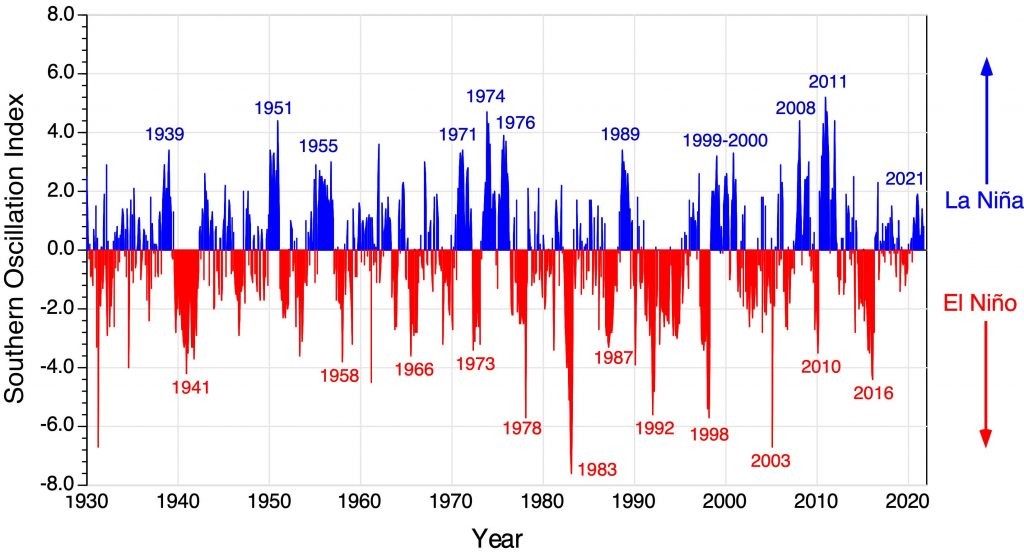

Figure 7. Relative strength El Niño and La Niña events from January 1930 to September 2021. Red indicates El Niño event while blue identifies La Niña event.

The Pacific Decadal Oscillation

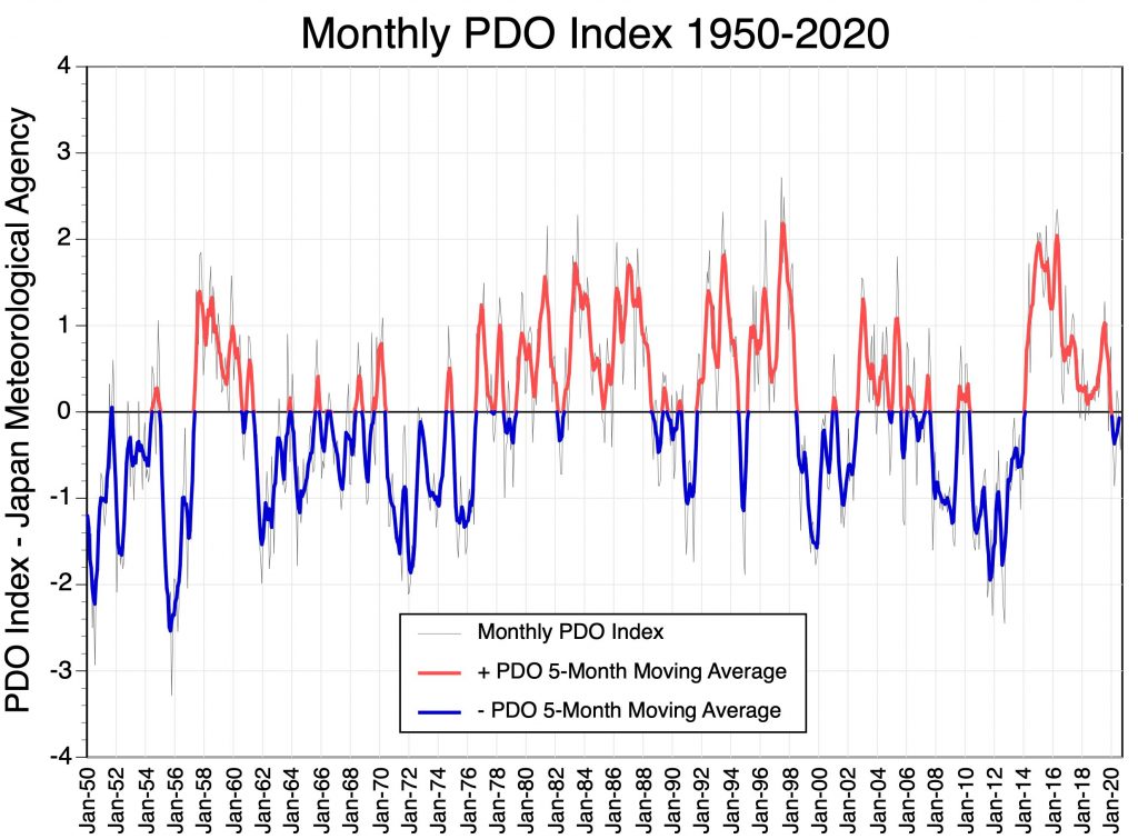
The Pacific Decadal Oscillation (PDO) is a cyclical pattern of ocean-atmosphere climate variability that occurs in the North Pacific Ocean. The PDO is detected as a change in sea surface temperatures over the Pacific Ocean from 20 to 60° North latitude. There are two phases that can last many years to several decades as shown in Figure 8. During the warm or positive phase, sea surface temperatures in the western North Pacific Ocean become cooler, while the eastern side of this ocean warms (Figure 9). The warm phase results in a zone of warm seawater hugging the west coast of North America from Alaska down to the Baja Peninsula. During the cold or negative phase, sea surface temperatures in the western North Pacific Ocean becomes warmer, while the eastern part of this ocean cools down (Figure 10). Significant reversals in the prevailing phase of the PDO have occurred around 1957, 1961, 1977, 1998, 2014, and 2020 (Figure 8).
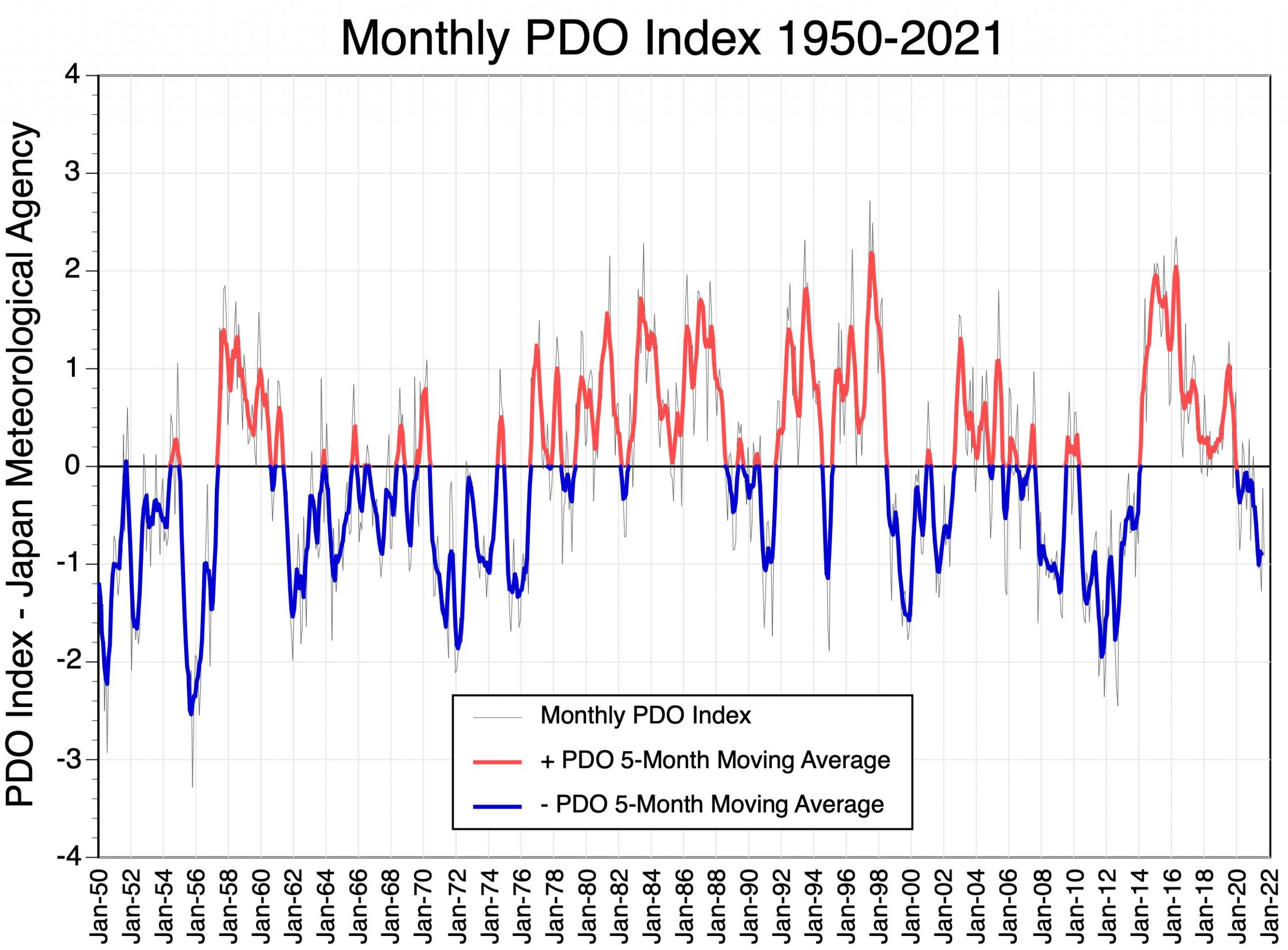

Figure 8. Relative strength and phase of the monthly Pacific Decadal Oscillation Index from January 1950 to September 2021. Values above zero indicate the warm or positive phase of the PDO and are colored red on the moving average line. Values below zero identify the cold or negative phase and are colored blue on the moving average line.
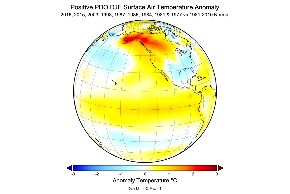

Figure 9. Surface temperature effects of the warm (positive) phase of the Pacific Decadal Oscillation during the winter season (December, January, and February) for the North American continent and the Pacific Ocean. This map describes the average temperature anomaly of nine significant warm episode years to the 30-year average 1981-2010.
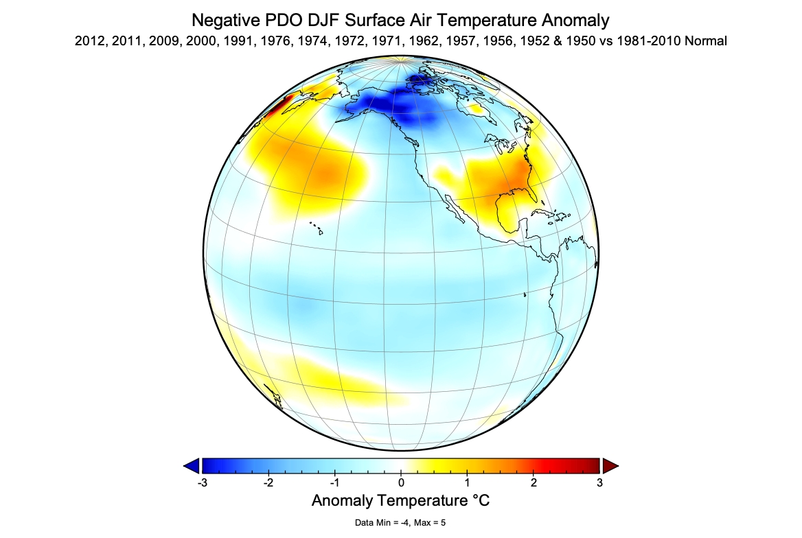

Figure 10. Surface temperature effects of the cold (negative) phase of the Pacific Decadal Oscillation during the winter season (December, January, and February) for the North American continent and the Pacific Ocean. This map describes the average temperature anomaly of fourteen significant cold episode years to the 30-year average 1981-2010.

Forecast Winter 2021/22

La Niña conditions are now being observed over the equatorial Pacific (Figure 11). Computer models suggest there is an 87% chance that La Niña will continue to exist in December, January, and February.
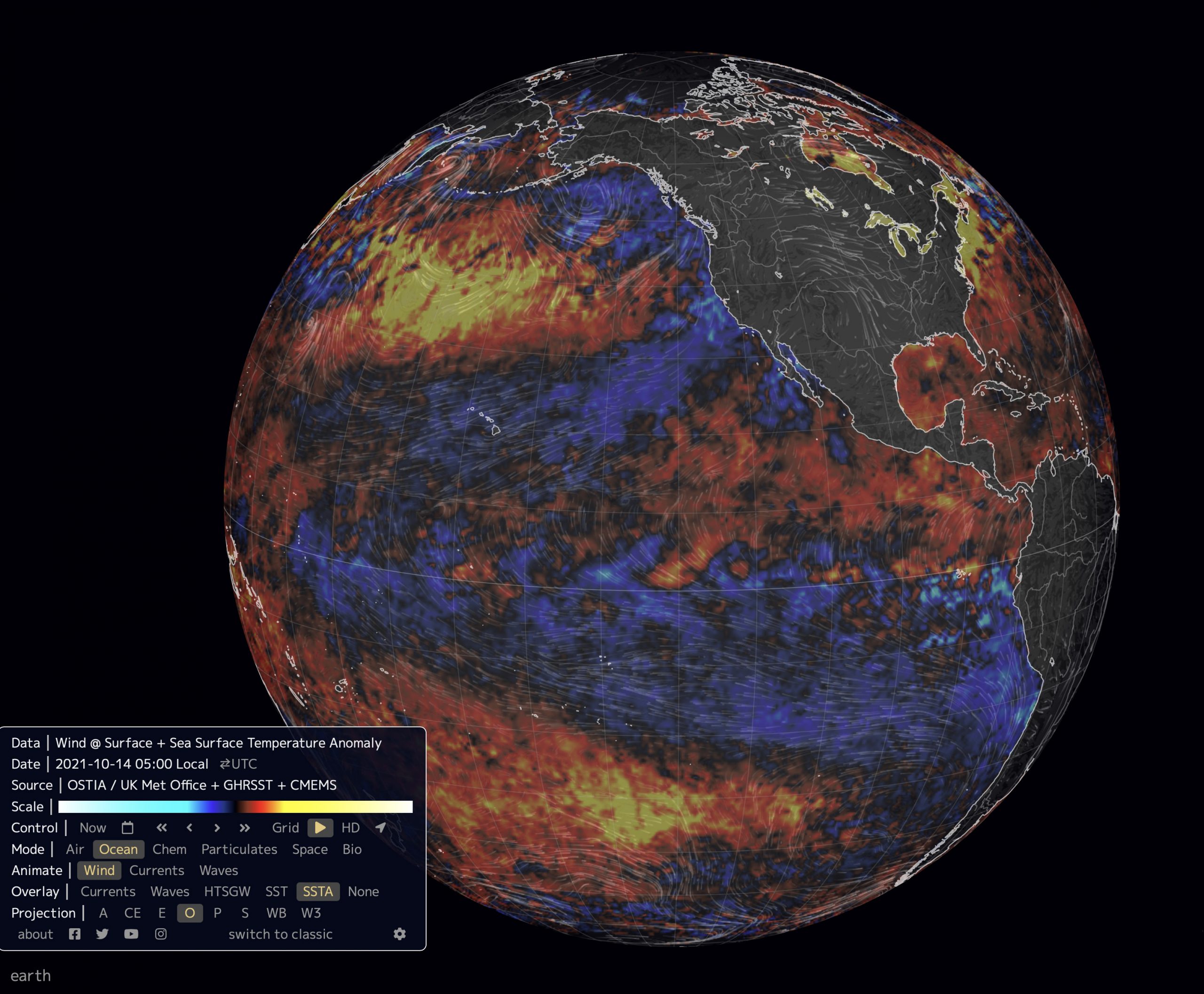

Figure 11. Pacific Ocean sea surface temperature anomalies for October 14, 2021. In this image, black represents a temperature no different than the 1981-2010 thirty-year average. Red to yellow indicates an above-normal temperature anomaly. Blue to light blue indicates a below-normal temperature anomaly. La Niña conditions are now observable along the equatorial Pacific. Also, an extensive area of cooler than average sea surface temperatures exists off the west coast of Canada and the USA. This pattern usually occurs when PDO is in its negative phase. (Image Source: https://earth.nullschool.net).

The Pacific Decadal Oscillation (PDO) index from January 2018 to September 2021 is shown in Figure 12 (and see web page Monthly PDO Index). From the summer of 2018 until fall 2019 the monthly PDO index rose from near zero to around +1.0. A sudden decline into negative territory occurred in October 2019, then a rebound to higher values in November and December, and mainly negative values from January 2020 to September 2021. 
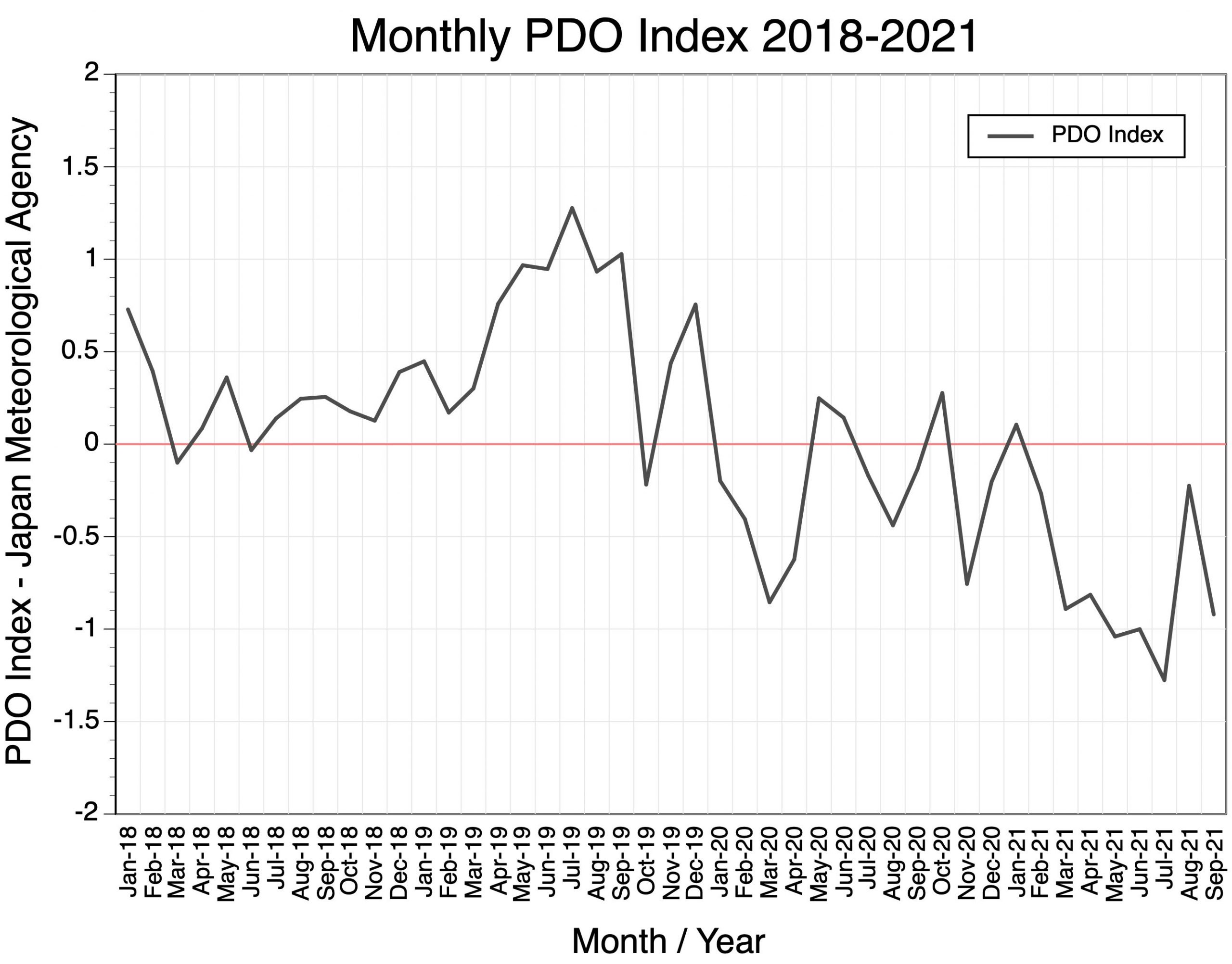

Figure 12. Relative strength and phase of the monthly Pacific Decadal Oscillation Index from January 2018 to September 2021. Values above zero indicate warm or positive phase, while values below zero identify cold or negative phase.

In conclusion, current patterns associated with La Niña and the Pacific Decadal Oscillation suggest that the climate of the winter of 2020/21 will be colder than normal with higher than normal precipitation for southern British Columbia and western Alberta.


Climate Prediction Center – North American Multi-Model Ensemble Long-Range Monthly Forecasts – October 2021

There is one more important piece of information that can provide us with some insight as to what the winter season will be like in Pacific Northwest USA and southern British Columbia in 2021/22. National Oceanic and Atmospheric Administration’s Climate Prediction Center creates long-range seasonal forecasts based on the average of seven different General Circulation Model simulations. Figure 13 describes the December surface mean temperature forecast for North America released in October 2021. This forecast suggests temperatures will be normal to slightly above-normal for southern British Columbia and Alberta, and 0.25 to 2.0°C above-normal for Washington state, eastern Oregon, Idaho, Montana, Utah, and Colorado.
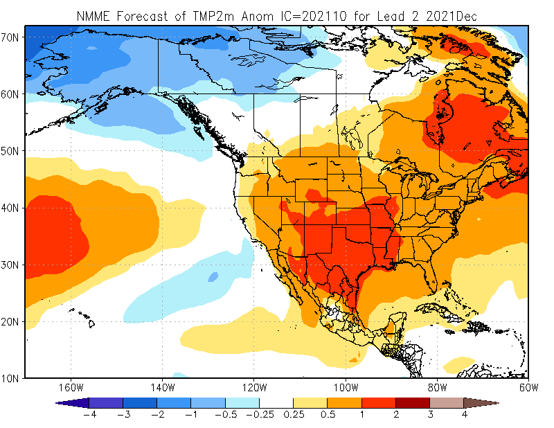

Figure 13. Climate Prediction Center – North American Multi-Model Ensemble surface temperature forecast for December 2021. October 2021 model run. Shown is the forecasted temperature anomaly relative to the 1981-2010 thirty-year average.

Figure 14 describes the December precipitation forecast for North America from the Climate Prediction Center released in November 2020. This forecast suggests well above-normal precipitation for much of British Columbia, Alberta Rocky Mountains, Washington state, Oregon, northern Idaho, and western Montana.
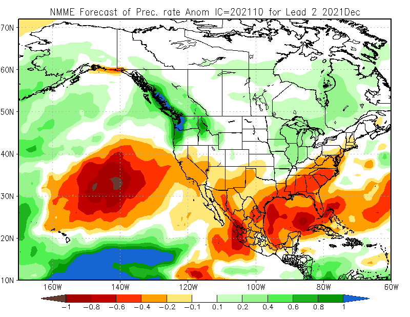

Figure 14. Climate Prediction Center – North American Multi-Model Ensemble precipitation forecast for December 2021. October 2021 model run. Shown is the forecasted precipitation anomaly relative to the 1981-2010 thirty-year average.

Climate Prediction Center – North American Multi-Model Ensemble Long-Range Seasonal Forecasts – January  2021 and February 2021.

Figures 15 and 16 describe respective January and February surface mean temperature forecasts for North America released in December 2020. The January forecast suggests temperatures will be below-normal for British Columbia, Alberta, Washington State, western Oregon, Montana, and northern Idaho (Figure 15). While southern California, Utah, Arizona, New Mexico, and Colorado will see above-normal temperatures.
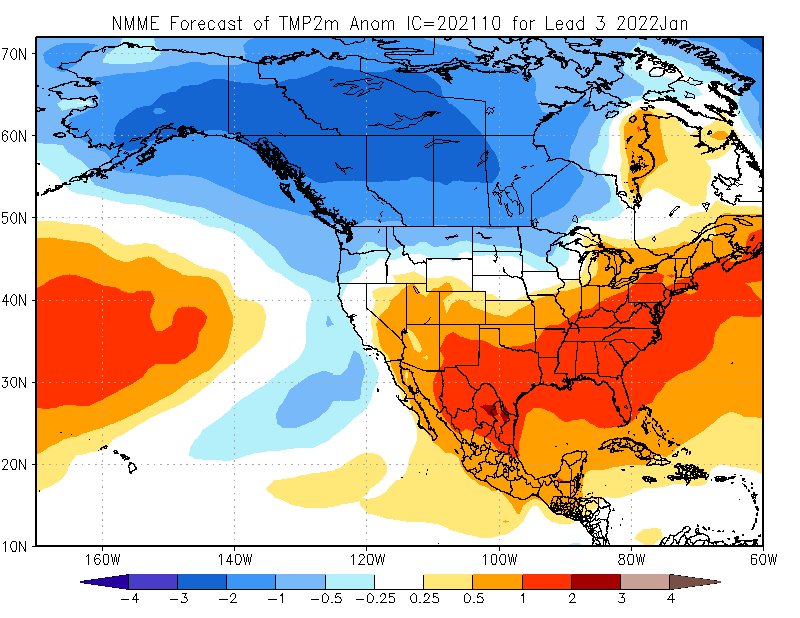

Figure 15. Climate Prediction Center – North American Multi-Model Ensemble surface temperature forecast for January 2022. October 2021 model run. Shown is the forecasted temperature anomaly relative to the 1981-2010 thirty-year average.

The February forecast suggests temperatures will be below-normal for most of British Columbia and Alberta (Figure 16). Normal temperatures will prevail in and Alberta, northern Montana, northern California, Oregon, and Washington state. While southern California, southern Idaho, southern Montana, Wyoming, Utah, Nevada, New Mexico, and Colorado will see above-normal temperatures.
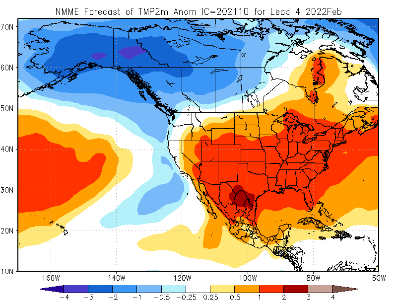

Figure 16. Climate Prediction Center – North American Multi-Model Ensemble surface temperature forecast for February 2022. October 2021 model run. Shown is the forecasted temperature anomaly relative to the 1981-2010 thirty-year average.

Figures 17 and 18 describe respective January and February precipitation rate forecasts for North America released in October 2021. The January forecast suggests precipitation will be above-normal for southern British Columbia, southern Alberta, Washington state, Oregon, Idaho, western Wyoming, and Montana (Figure 17). Below-normal precipitation will occur in California, southern Nevada, southern New Mexico, and Arizona. Elsewhere precipitation conditions will be near normal.
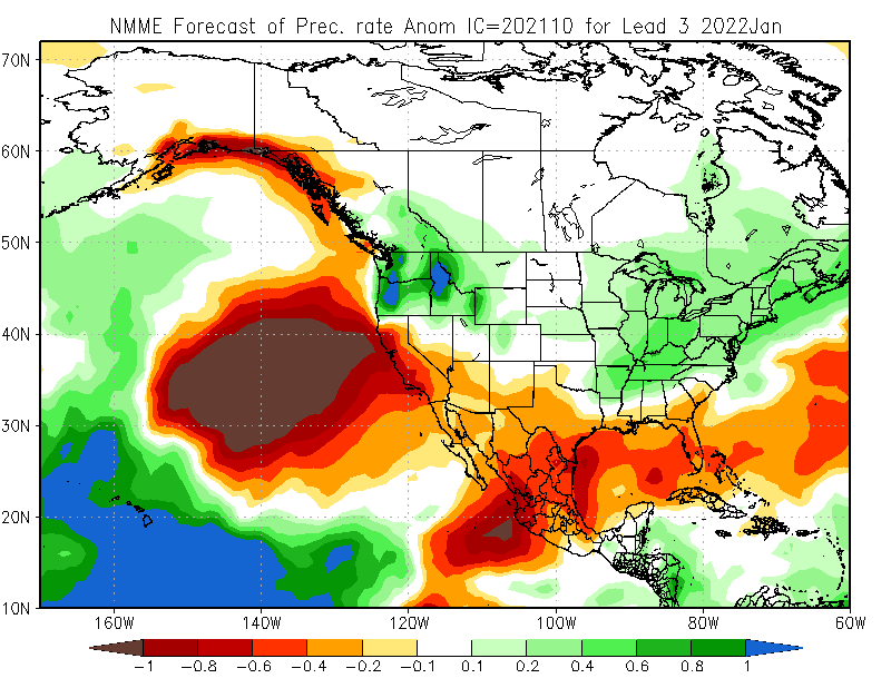

Figure 17. Climate Prediction Center – North American Multi-Model Ensemble precipitation forecast for January 2022. October 2021 model run. Shown is the forecasted precipitation rate anomaly relative to the 1981-2010 thirty-year average.

The February forecast suggests precipitation will be above-normal in Washington state, most of Idaho, Oregon, western Montana, much of British Columbia, and western Alberta (Figure 18). California, New Mexico, Utah, Colorado, and Arizona will see below-normal precipitation. 
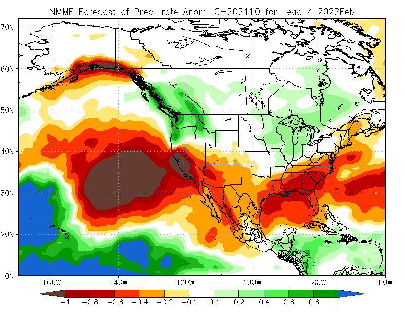

Figure 18. Climate Prediction Center – North American Multi-Model Ensemble precipitation forecast for February 2022. October 2021 model run. Shown is the forecasted precipitation rate anomaly relative to the 1981-2010 thirty-year average.
2020/21 Winter Forecast for Western Canada’s Ski Resorts

by MICHAEL PIDWIRNY

Introduction

During the winter months of December, January, and February the climate of the northwest USA and southern British Columbia is defined by cooling temperatures and an increase in precipitation. Temperatures cool mainly because of the reduction in heat energy supplied by the Sun. During the winter months, the intensity of the solar radiant energy declines because of lower Sun angles and a shortening of day length. Figure 1 describes the average near-surface temperature (2 meters above ground level) for the winter season. Temperatures along the west coast are moderated by the stored heat energy found in the surface waters of the Pacific Ocean.


Figure 1. Average winter near-surface mean temperature (°C) for the North American continent and adjacent oceans for the period 1981-2010. Source: Climate Reanalyzer – https://climatereanalyzer.org.

Figure 2 describes the typical patterns of winter precipitation for North America. High amounts of precipitation occur along much of the west coast because of mid-latitude cyclones and orographic uplift. During winter, mid-latitude cyclones often originate in the northeastern Pacific Ocean and then move in an easterly direction. Orographic enhancement of the quantity of precipitation falling occurs because of the presence of mountains found running from Alaska to California. Central North America is relatively dry compared to the west coast because most of the precipitable water held in the clouds of the mid-latitude cyclones previously precipitated out and the cold continental air masses found here hold little moisture.


Figure 2. Average winter precipitation over North American continent and the adjacent oceans for the period 1981-2010. Source: Climate Reanalyzer – https://climatereanalyzer.org.

Variation in year-to-year winter weather of the northwest USA and southern British Columbia is strongly influenced by several large-scale cyclic climate phenomena which modify large scale atmospheric circulation and sea surface temperatures in the Pacific Ocean. Further, these climate factors tend to have a significant impact on temperature and precipitation trends during the winter months over southern British Columbia and Washington state. El Niño – usually brings warmer than average winters and below-average precipitation to this area of the Pacific Northwest. La Niña – is often associated with cold winters with average to above-normal precipitation. Generally, the effects of significant El Niño and La Niña are limited to one or maybe two consecutive winter seasons. Operating on a much longer timescale of one to three decades there is another cyclic climate factor of importance known as the Pacific Decadal Oscillation. The Pacific Decadal Oscillation seesaws between a warm or a cold state and these phases seem to amplify the climatic effects of co-occurring El Niño and La Niña events, respectively.

El Niño

El Niño is the name given to the cyclical development of warm ocean surface waters on the east side of Pacific Ocean at the equator. This climate event usually occurs around Christmas and usually lasts for a few weeks (weak) to a few months (strong). El Niño is created by a reduction in the speed of the Trade Winds right along the equator which results in a shift in atmospheric circulation and pressure patterns in this region of the planet (Figure 3). Sometimes an extremely warm El Niño can develop and last for more than a year. Since 1935, significant El Niño events have developed in 1958, 1966, 1978, 1983, 1987, 1990, 1992, 1993, 1998, 2005, 2010 and 2016. Figure 4 shows the general global patterns of winter surface temperature warming and cooling associated with El Niño.


Figure 3. Cross-section along the Pacific Ocean at the equator during an El Niño event. Notice associated atmospheric circulation patterns and direction of warm seawater pulse in the ocean.


Figure 4. December to February near surface temperature anomaly based on the average of twelve El Niño years relative to the 1981-2010 normal average.

La Niña

La Niña is the name given to the cyclical development of cold ocean surface waters on the east side of Pacific Ocean at the equator. Similar to El Niño , a La Niña climate event usually occurs around Christmas and normally lasts for a few weeks (weak) to a few months (strong). La Niña is created by an increase in the speed of the Trade Winds along the equator which results in a shift in atmospheric circulation and pressure patterns in this region of the planet (Figure 5). Sometimes an extremely cold La Niña can develop and last for more than a year. Since 1935, significant La Niñas have occurred in 1950, 1956, 1967, 1971, 1974, 1976, 1999, 2008, and 2011. Figure 6 shows the general global patterns of winter surface temperature cooling and warming associated with La Niña.


Figure 5. Cross-section along the Pacific Ocean at the equator during a La Niña event. Notice associated atmospheric circulation patterns and direction of cold seawater pulse in the ocean.


Figure 6. December to February near-surface temperature anomaly based on the average of ten La Niña years relative to the 1981-2010 normal average.

Figure 7 shows the relative strength of El Niño and La Niña events from 1930 to 2019 accord to the Southern Oscillation Index (SOI). On this figure, negative values indicate El Niño conditions with lower values suggesting stronger events. High positive values indicate significant La Niña events.


Figure 7. Relative strength El Niño and La Niña events from January 1930 to October 2019. Red indicates El Niño event while blue identifies La Niña event.

The Pacific Decadal Oscillation

The Pacific Decadal Oscillation (PDO) is a cyclical pattern of ocean-atmosphere climate variability that occurs in the North Pacific Ocean. The PDO is detected as a change in sea surface temperatures over the Pacific Ocean from 20 to 60° North latitude. There are two phases that can last many years to several decades as shown in Figure 8. During the warm or positive phase, sea surface temperatures in the western North Pacific Ocean become cooler, while the eastern side of this ocean warms (Figure 9). The warm phase results in a zone of warm seawater hugging the west coast of North America from Alaska down to the Baja Peninsula. During the cold or negative phase, sea surface temperatures in the western North Pacific Ocean becomes warmer, while the eastern of this ocean cools down (Figure 10). Significant reversals in the prevailing phase of the PDO have occurred around 1957, 1961, 1977, 1998, and 2014 (Figure 8).


Figure 8. Relative strength and phase of the monthly Pacific Decadal Oscillation Index from January 1950 to September 2020. Values above zero indicate warm or positive phase of the PDO and are coloured red on the moving average line. Values below zero identify the cold or negative phase and are coloured blue on the moving average line.


Figure 9. Surface temperature effects of the warm (positive) phase of the Pacific Decadal Oscillation during the winter season (December, January, and February) for the North American continent and Pacific Ocean. This map describes the average temperature anomaly of nine significant warm episode years to the 30-year average 1981-2010.


Figure 10. Surface temperature effects of the cold (negative) phase of the Pacific Decadal Oscillation during the winter season (December, January, and February) for the North American continent and Pacific Ocean. This map describes the average temperature anomaly of fourteen significant cold episode years to the 30-year average 1981-2010.

Forecast Winter 2020/21

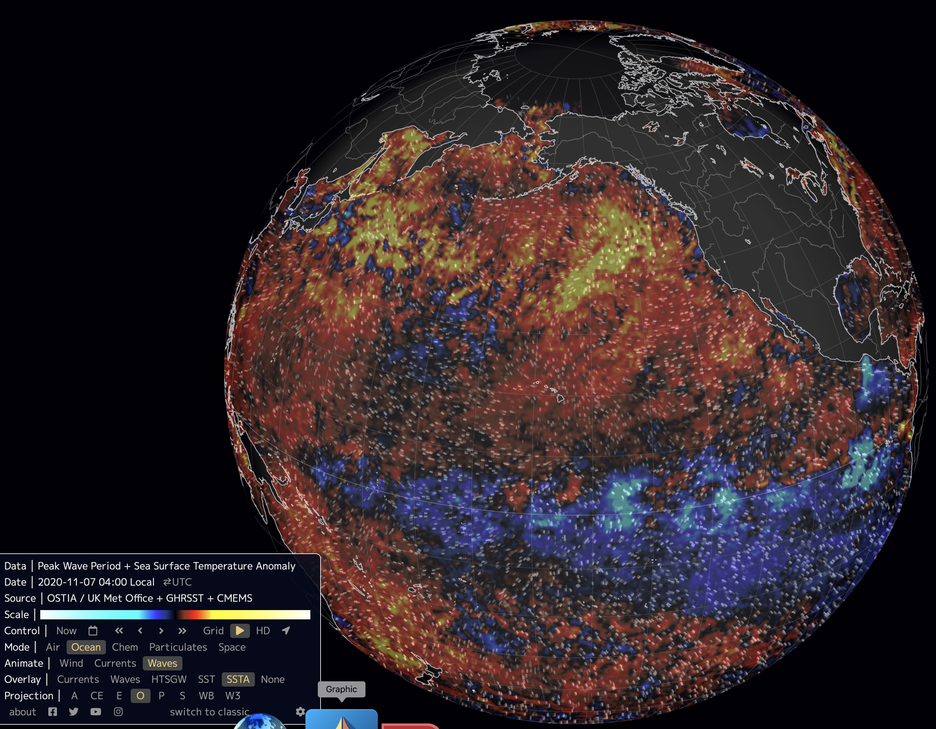
La Niña conditions are now being observed over the equatorial Pacific (Figure 11). Computer models suggest there is an 85% chance that La Niña will continue in December, January, and February.


Figure 11. Pacific Ocean sea surface temperature anomalies for November 7, 2020. In this image, black represents a temperature no different than the 1981-2010 thirty-year average. Red to yellow indicates an above-normal temperature anomaly. Blue to light blue indicates a below-normal temperature anomaly. La Niña conditions are now observable along the equatorial Pacific. However, an extensive area of warmer than average sea surface temperatures exists off the west coast of Canada and the USA. This pattern usually occurs when PDO is in its positive phase. (Image Source: https://earth.nullschool.net).

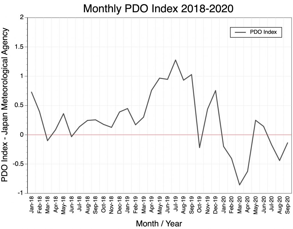
The Pacific Decadal Oscillation (PDO) index from January 2018 to September 2020 is shown in Figure 12 (and see web page Monthly PDO Index). From the summer of 2018 until fall 2019 the monthly PDO index rose from near zero to around +1.0. A sudden decline into negative territory occurred in October 2019, then a rebound to higher values in November and December, and mainly negative values from January to September 2020. 


Figure 12. Relative strength and phase of the monthly Pacific Decadal Oscillation Index from January 2018 to September 2020. Values above zero indicate warm or positive phase, while values below zero identify cold or negative phase.

In conclusion, current patterns associated with La Niña and the Pacific Decadal Oscillation suggest that the climate of the winter of 2020/21 will be colder than normal with higher than normal precipitation for southern British Columbia and western Alberta.


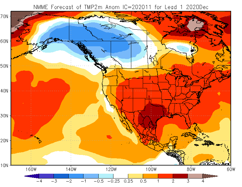
Climate Prediction Center – North American Multi-Model Ensemble Long-Range Monthly Forecasts – December 2020

There is one more important piece of information that can provide us with some insight as to what the winter season will be like in Pacific Northwest USA and southern British Columbia in 2020/21. National Oceanic and Atmospheric Administration’s Climate Prediction Center creates long-range seasonal forecasts based on the average of seven different General Circulation Model simulations. Figure 13 describes the December surface mean temperature forecast for North America released in November 2020. This forecast suggests temperatures will be normal for southern British Columbia and Alberta, and 0.25 to 2.0°C above-normal for Washington state, eastern Oregon, Idaho, Montana, Utah, and Colorado.


Figure 13. Climate Prediction Center – North American Multi-Model Ensemble surface temperature forecast for December 2020. November 2020 model run. Shown is the forecasted temperature anomaly relative to the 1981-2010 thirty-year average.

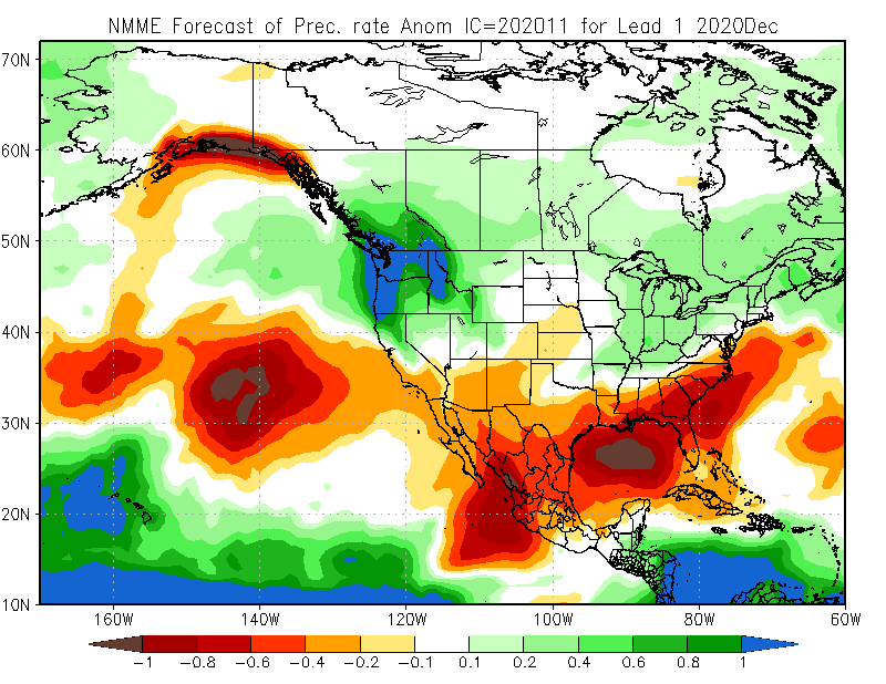
Figure 14 describes the December precipitation forecast for North America from the Climate Prediction Center released in November 2020. This forecast suggests well above-normal precipitation for much of British Columbia, Alberta Rocky Mountains, Washington state, Oregon, northern Idaho, Montana, and northern California.


Figure 14. Climate Prediction Center – North American Multi-Model Ensemble precipitation forecast for December 2020. November 2020 model run. Shown is the forecasted precipitation anomaly relative to the 1981-2010 thirty-year average.

Climate Prediction Center – North American Multi-Model Ensemble Long-Range Seasonal Forecasts – January  2021 and February 2021.

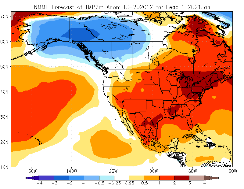
Figures 15 and 16 describe respective January and February surface mean temperature forecasts for North America released in December 2020. The January forecast suggests temperatures will be slightly below-normal for British Columbia and Alberta. Mainly normal for Washington State, Oregon, Montana, and northern Idaho (Figure 15). While much of California, Idaho, Wyoming, Utah, and Colorado will see above-normal temperatures.


Figure 15. Climate Prediction Center – North American Multi-Model Ensemble surface temperature forecast for January 2021. December 2020 model run. Shown is the forecasted temperature anomaly relative to the 1981-2010 thirty-year average.

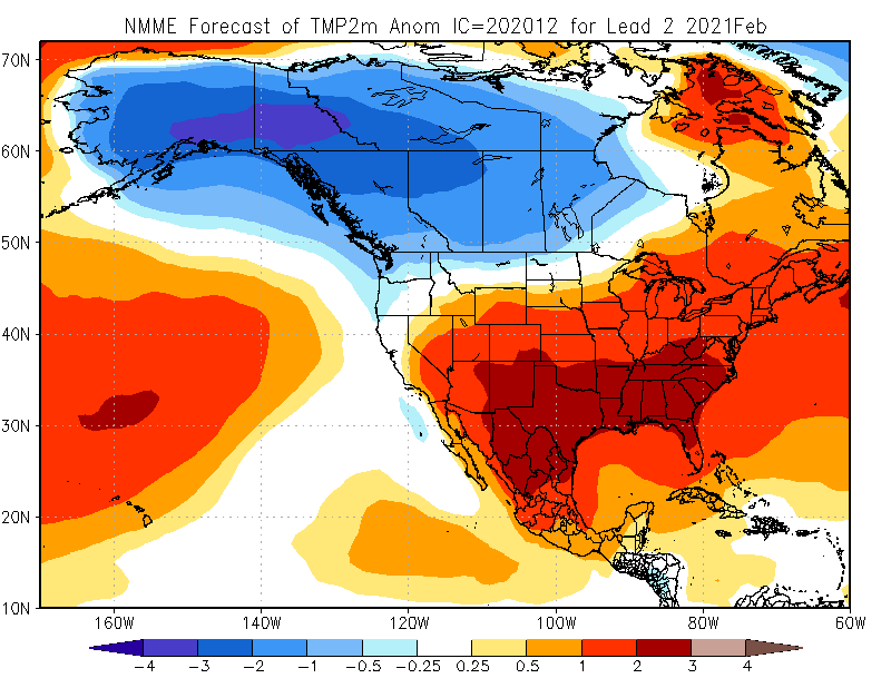
The February forecast suggests temperatures will be below-normal for British Columbia, Alberta, Montana, Oregon, and Washington state (Figure 16). While California, Idaho, Wyoming, Utah, and Colorado will see normal to above-normal temperatures.


Figure 16. Climate Prediction Center – North American Multi-Model Ensemble surface temperature forecast for February 2021. December 2020 model run. Shown is the forecasted temperature anomaly relative to the 1981-2010 thirty-year average.

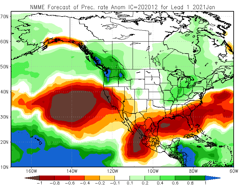
Figures 17 and 18 describe respective January and February precipitation rate forecasts for North America released in December 2020. The January forecast suggests precipitation will be above-normal for most of British Columbia, Alberta, Washington state, Oregon, Idaho, western Wyoming, western Colorado, and Montana (Figure 17). Below-normal precipitation will occur in California. Elsewhere precipitation conditions will be near normal.


Figure 17. Climate Prediction Center – North American Multi-Model Ensemble precipitation forecast for January 2021. December 2020 model run. Shown is the forecasted precipitation rate anomaly relative to the 1981-2010 thirty-year average.
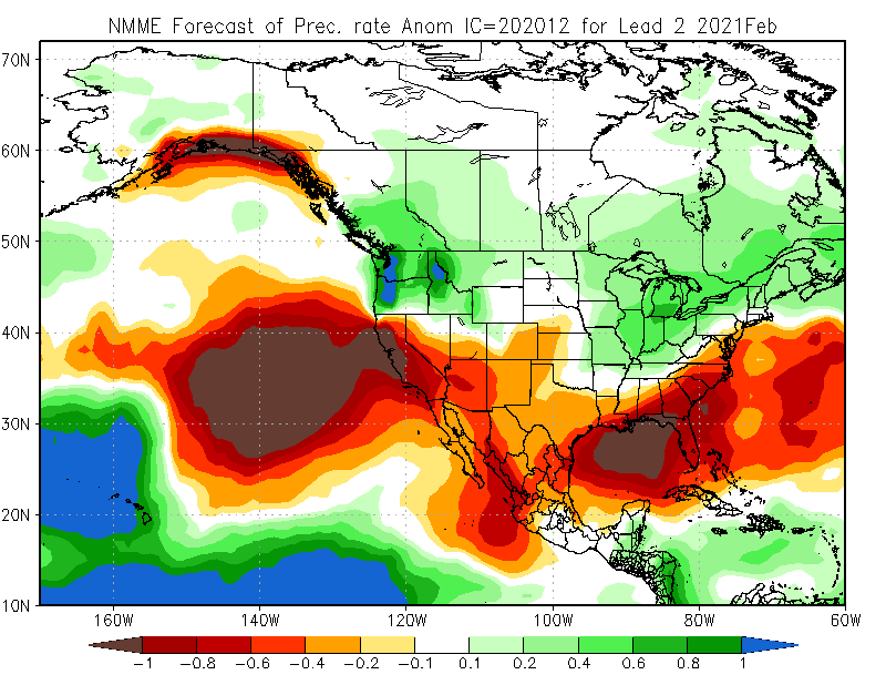
The February forecast suggests precipitation will be above-normal in Washington state, northern Idaho, Oregon, western Montana, and southern British Columbia, and western Alberta (Figure 18). Near normal for much of Utah and Colorado. California, New Mexico, and Arizona will see below-normal precipitation. 


Figure 18. Climate Prediction Center – North American Multi-Model Ensemble precipitation forecast for February 2021. November 2020 model run. Shown is the forecasted precipitation rate anomaly relative to the 1981-2010 thirty-year average.
Impact of Future Climate Change on Ski Season Length for Western North American Ski Resorts

by ETHAN CLARK and MICHAEL PIDWIRNY 

Objectives

The purpose of our research was to determine the impact of future climate change on the length of the ski season for 154 selected resorts in Western North America. This research uses climate databases ClimateBC and ClimateNA to produce high quality historical data and future predicted data from 15 global climate models (GCMs). Using monthly temperature data, we were able to model the length of ski season at each resort’s mid-elevation for the normal period 1971-2000 and two emission scenarios, RCP4.5. (best-case scenario) and RCP8.5 (worst-case scenario), for the year 2085.

Introduction

Several studies have suggested that the winter recreational activities of skiing and snowboarding will be severely impacted by changes in temperature and precipitation driven by future human caused climate change. Skiing and snowboarding are activities normally done in the winter season when temperatures are below freezing and precipitation falls as snow. Climate change should cause the length of the ski season to shorten, mainly controlled by warming temperatures. This research uses monthly temperature to model the changes in ski season length for 154 ski resorts in Western North America under RCP4.5 and RCP8.5 emission scenario to the year 2085.

Methods

1) We identified 154 major ski resorts in Western North America and determined their mid-elevation using OntheSnow.com.

2) Using Google Earth for each ski resort we determined their exact decimal degree latitudinal and longitudinal location (to 4 decimal points) for a point on the resort that was at mid-elevation and roughly at its geographic center.

3) Climate databases ClimateBC and ClimateNA (Wang et al., 2016) were used to generate statistically downscaled, spatially interpolated, and altitude adjusted historical monthly mean temperature data for the thirty years between 1971-2000.

4) ClimateBC and ClimateNA were also used to produce future forecasted monthly mean temperature data for the year 2085 under RCP4.5 and RCP8.5 emission scenarios for 15 different GCMs used in the IPCC’s 5th Assessment Report.

5) For each ski resort, daily mean temperature curves were constructed using polynomial regression from the monthly data for the average of 1971-2000 and for the average of 15 GCM results for both RCP emission scenarios.

6) Ski season length (number of days) was calculated from the daily mean temperature curves using a 0°C threshold.

7) A Geographical Information System was used to map the ski season length of each resort for the historical average of 1971-2000, RCP4.5 2085, and RCP8.5 2085. To simplifying the map display, ski season length was grouped as being either 0 days, 1-30, 31-60, 61-90, 91-120, 121-150, 151-180, and greater than 180 days for the resorts studied.

Results

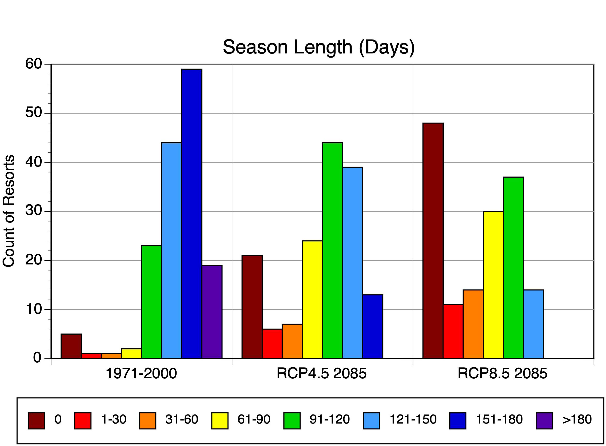
Figures 1, 2 and 3 display the calculated ski season length of each ski resort for the historical normal of 1971-2000, RCP4.5 2085, and RCP8.5 2085, respectively. Figure 4 shows the same data in three histograms.


Figure 1. Length of ski season under 1971-2000 period for selected ski resorts in Western North America.


Figure 2. Length of ski season under RCP4.5 for 2085 for selected ski resorts in Western North America.


Figure 3. Length of ski season under RCP8.5 for 2085 for selected ski resorts in Western North America.


Figure 4. Distribution of binned length of ski season data for 1971-2000 normal, and RCP4.5 and RCP8.5 emission scenarios for 2085.


Discussion and Conclusions

The spatial distribution of season length at Western North American ski resorts shows there is a clear difference between coastal versus continental resorts in the climate normal period and both RCP4.5 and RCP8.5 emission scenarios (Figures 1, 2 and 3). Resorts close to the coast are moderated in temperature by the Pacific Ocean leading to shorter ski seasons. Interior resorts experience the effect of continentality which causes colder winter temperatures and longer ski seasons.

The histograms in Figure 4 show a dramatic shift in season lengths from 1971-2000 to future scenarios. During the historical period, only five ski resorts were calculated to have no definable ski season. These resorts are found in California and they operate only under ideal conditions. For the future forecast, the number of ski resorts with no definable ski season increases to 21 and 48 for the RCP4.5 and 8.5 emission scenarios, respectively. The resorts with no definable ski season are located in close proximity to the North American coast. Removing resorts with no ski season, we calculate the average ski season length to be 153 days for the 1971-2000 climate normal period, 108 days for RCP4.5, and 83 days for RCP8.5.

For many ski resorts in Western North America, the heart of ski season currently runs from the beginning of December to the end of March or approximately 120 days. For the 1971-2000 climate normal period, our analysis indicates that 79% of the resorts we studied have a season length of 120 days or greater. Our future forecast suggests that resorts with a season length of 120 days or greater decreases to 34% with RCP4.5 and only 9% under RCP8.5 by 2085.

While both emission scenarios will cause significant decreases in ski season length, the best-case RCP4.5 scenario is clearly a better outcome. This stresses the importance for ski resorts and other winter sports stakeholders to be active lobbyists against future climate change through the reduction greenhouse gases emissions.

References

Wang, T., A. Hamann, D. Spittlehouse and C. Carrol 2016. Locally downscaled and spatially customizable climate data for historical and future periods for North America. PLos ONE 11(6) doi:10.1371/journal.pone.0156720.

Climate Change Challenges for Alpine Ski Resorts in Western Canada

by MICHAEL PIDWIRNY, ETHAN CLARK, and KALIM BAHBAHANI 

Introduction

By the end of the 21st century, the Intergovernmental Panel on Climate Change (IPCC) predicts that the continued emission of greenhouse gases by human activity will significantly increase surface air temperatures and change patterns of precipitation on our planet at local, regional, and global spatial scales. Being able to forecast how climate change will influence socio-economic systems is important to assess potential impact to humans. Understanding this impact will also allow for the development of effective adaptation and mitigation strategies to minimize the negative effects of climate change.

Analysis of the climatic impacts associated with human caused climate change at alpine ski resorts is quite straightforward using recently developed techniques which mathematically interpolate measurements from weather stations to other nearby locations. The research presented here uses spatially interpolated climate data which is generated by the software databases ClimateBC and ClimateNA (Wang et al., 2016). These climate software databases can produce data for the historical period 1901-2018 and future climate forecasts for the 21st century generated by climate simulation models used in the 5th Assessment Report of the IPCC.

Historical Trends – Cypress Ski Resort

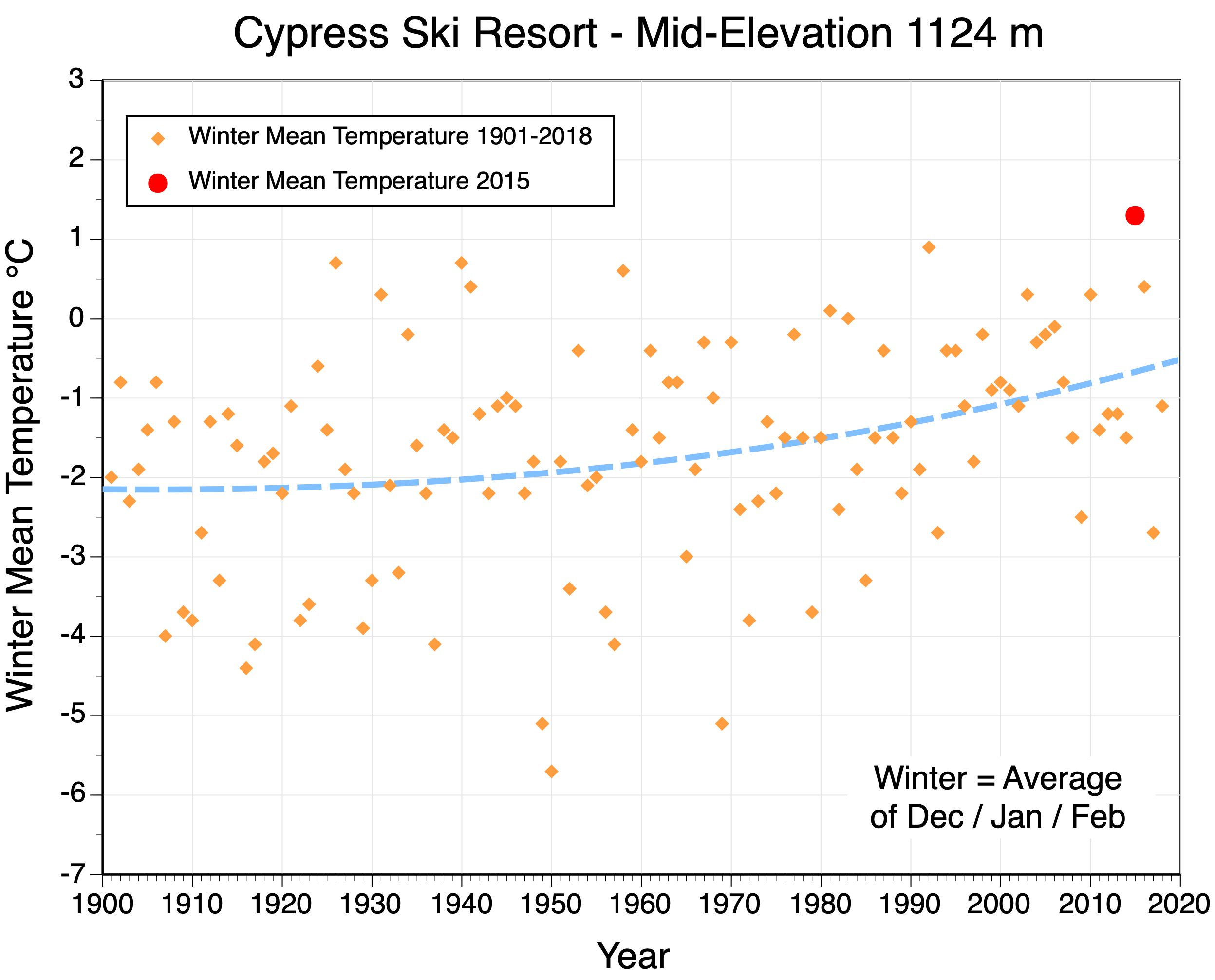
Alpine ski resorts in western Canada receive considerable year-to-year variation in surface air temperature and snowfall during the winter season (December, January, and February). This variability can sometimes hide trends when the data record is short. Figure 1 illustrates the variation in winter mean temperature for Cypress Ski Resort located just north of Vancouver, British Columbia for the period 1901 to 2018. Over this 118-year period, we can observe an obvious warming trend for winter mean temperature of about 1.5° C. It is important to note that the winter mean temperature of 2015 was warm enough to cause this resort to close down for most of that ski season.


Figure 1. Observed winter mean temperatures from 1901 to 2018 at Cypress Ski Resort, elevation 1124 meters. The segmented blue line describes the best-fit trend line through the 118 yearly observations. This graph also identifies the year 2015, the warmest winter in the history of Cypress.


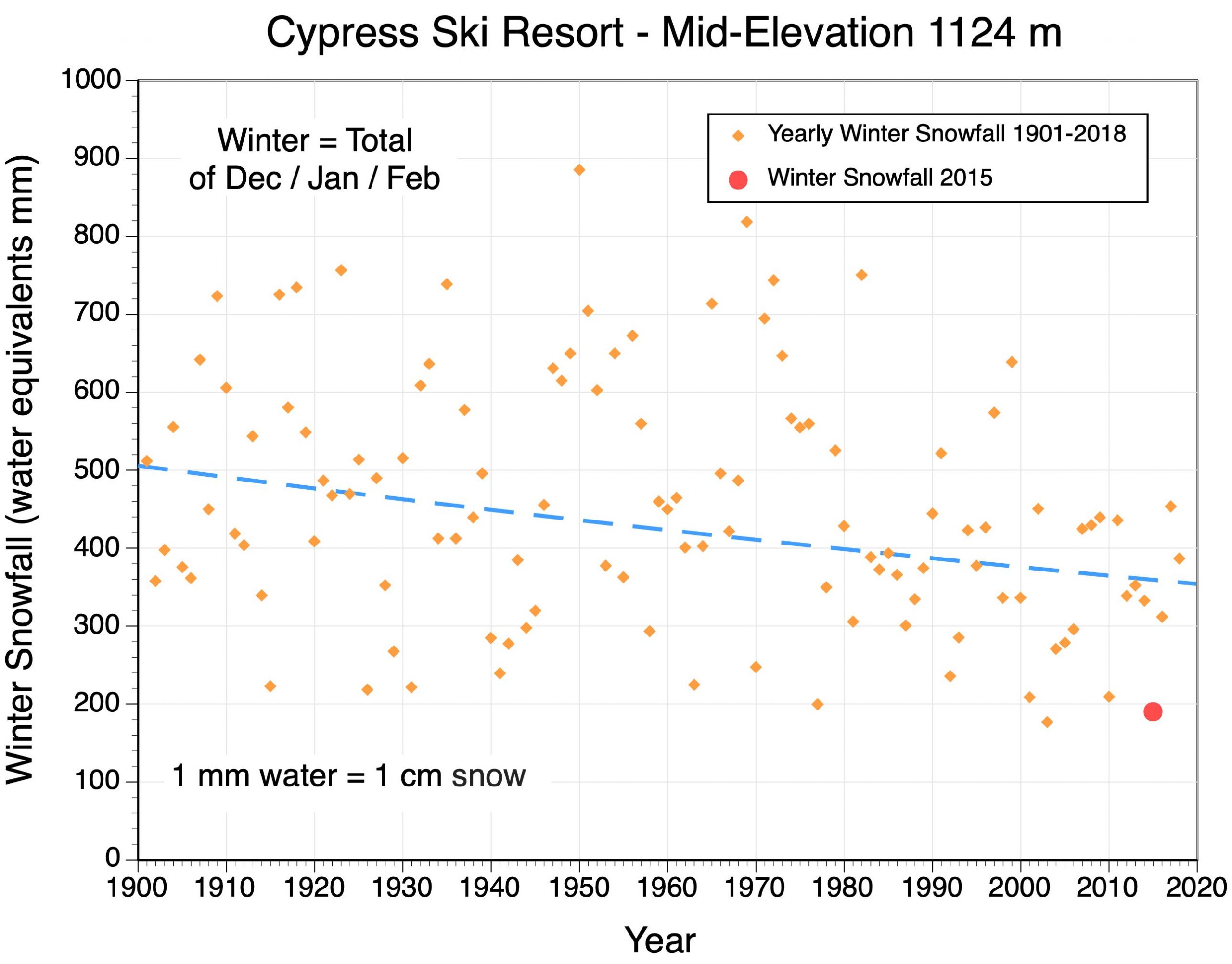
Figure 2 describes the variation in winter snowfall for Cypress Ski Resort for the period 1901 to 2018. On this graph, we see a trend of less snow falling at this resort over time. In the first half Snowfalls averaged about 475 cms in the first half of the 20th century. In the first 18 years of the 21st century, winter snowfalls declined by about 30% now averaging 332 cms.


Figure 2. Observed winter snowfall from 1901 to 2018 at Cypress Ski Resort, elevation 1124 meters. The segmented blue line describes the best-fit trend line through the 118 yearly observations. This graph also identifies the year 2015, the warmest winter in the history of Cypress.


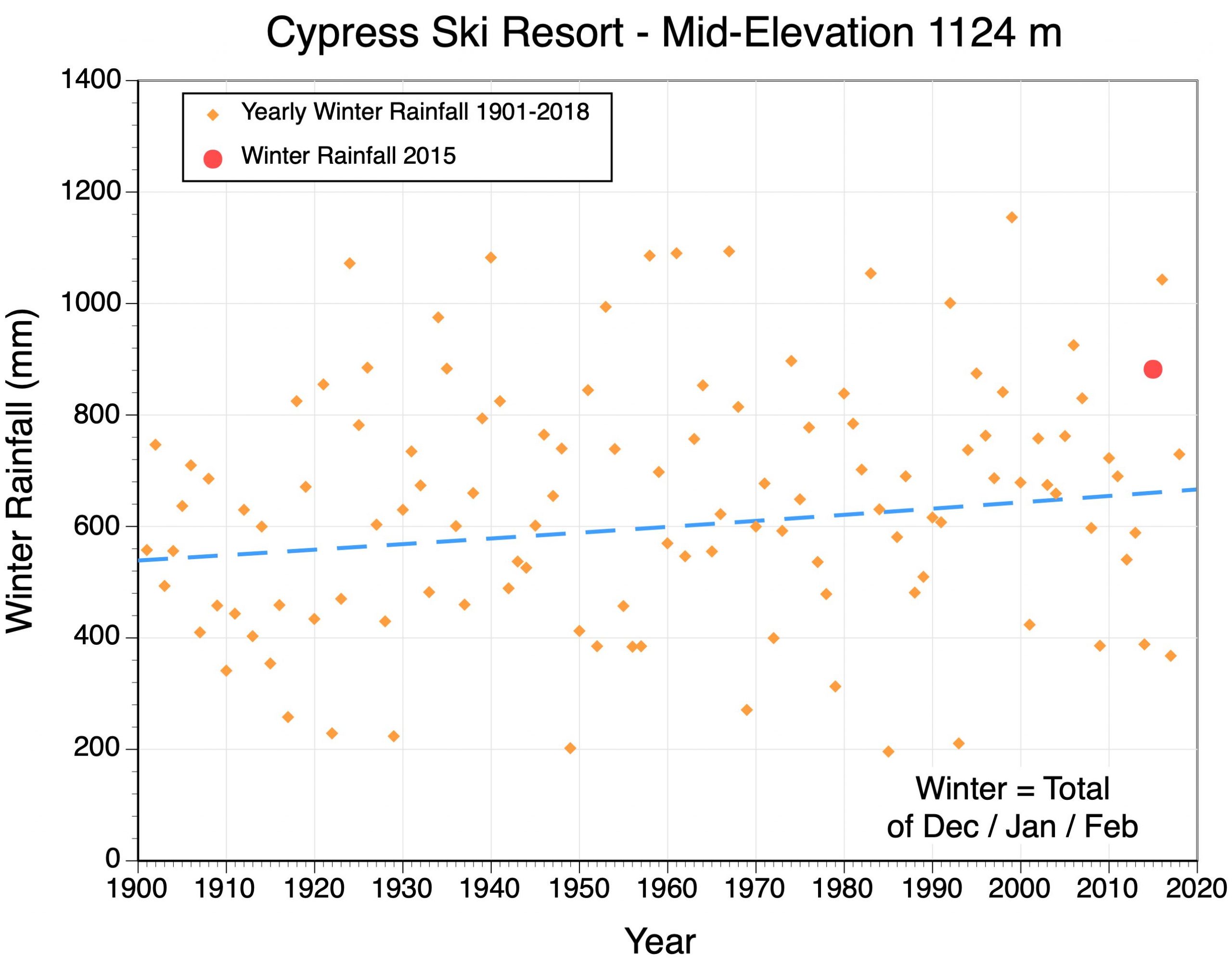
Warming winter temperatures have also caused an increase in the amount of rain that falls at Cypress ski resort (Figure 3). Over the period 1901 to 2018, rainfall increased by approximately 22%.


Figure 3. Observed winter rainfall from 1901 to 2018 at Cypress Ski Resort, elevation 1124 meters. The segmented blue line describes the best-fit trend line through the 118 yearly observations. This graph also identifies the year 2015, the warmest winter in the history of Cypress.


Future Trends at Ski Resorts in Western Canada

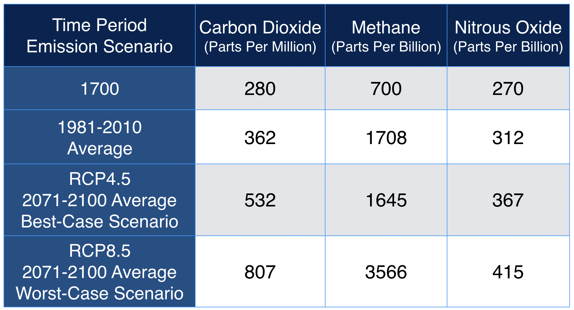
We can also use ClimateBC and ClimateNA to forecast how future climate change will affect Cypress Ski Resort and other resorts in western Canada. However, the exact nature of this climate change is somewhat uncertain because there is a possibility that we will be successful in limiting future greenhouse gas emissions into the atmosphere. Table 1 describes the estimated future atmospheric concentrations of the main greenhouse gases under a best-case (called RCP4.5) and a worst-case (called RCP8.5) scenario available in ClimateBC and ClimateNA. The best-case scenario correlates to a warming of the Earth’s surface globally of about 2.4° C relative to pre-industrial greenhouse gas levels. Many climate scientists believe this scenario can be achieved if nations act soon to reduce emissions primarily through reforestation, other carbon capture techniques, increased energy-use efficiency and switching to renewable based energy generation. The worst-case scenario corresponds to a future pathway where greenhouse gas emissions continue to increase exponentially and average global temperature becomes 4.3° C warmer by 2100.


Table 1. Historic and future forecasted concentrations of carbon dioxide, methane and nitrous oxide in the lower atmosphere.


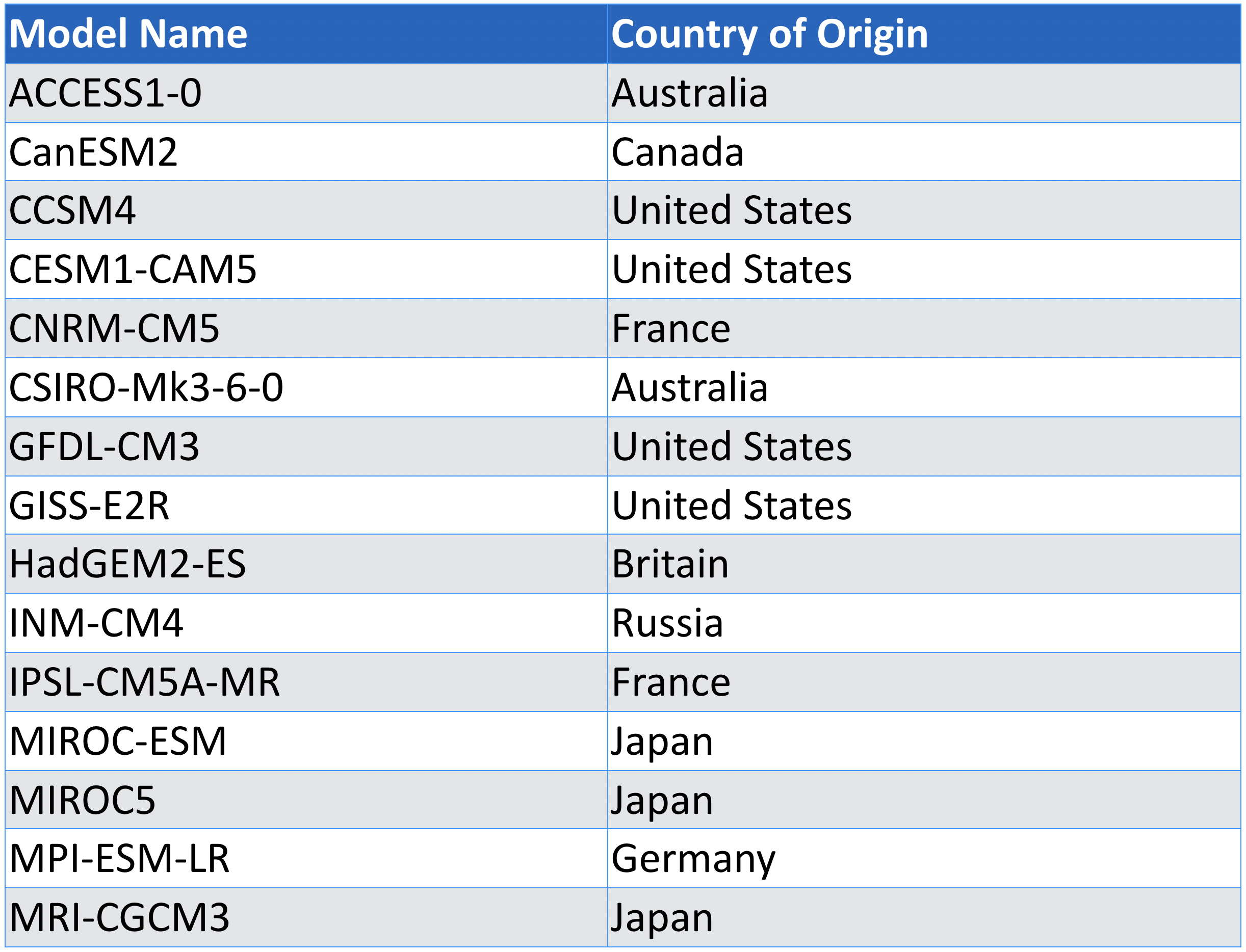
ClimateBC and ClimateNA provide data from fifteen global climate models for future forecasting (Table 2). These carefully selected fifteen models provide the same range of values that the more than 40 models provided in the IPCC’s Fifth Assessment Report (Knutti, Masson, and Gettelman, 2013). Our future forecasts for the twelve ski resorts studied present the mean value of these fifteen global climate models with error bars representing one standard deviation.


Table 2. The fifteen global climate models available in ClimateBC and ClimateNA.


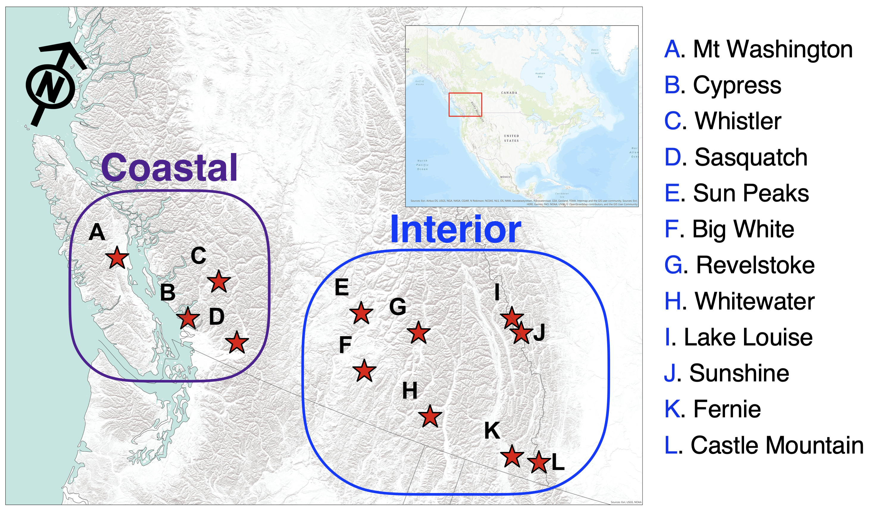
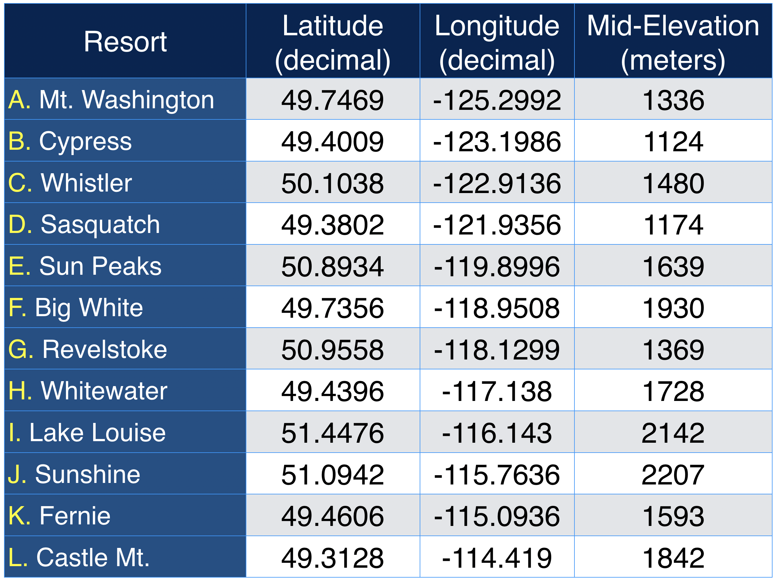
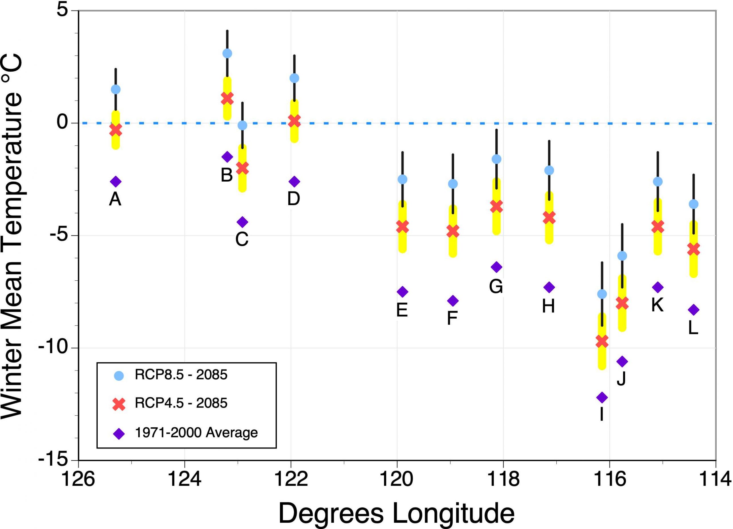
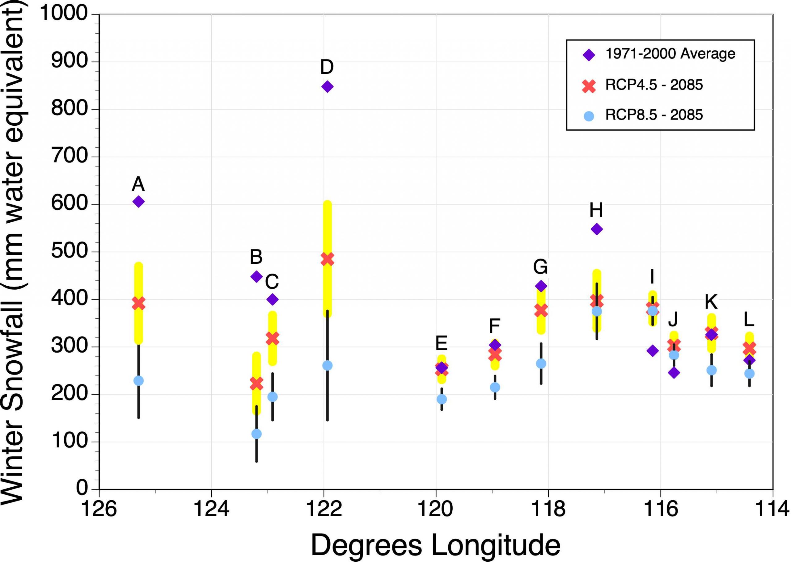
Figures 3, 4 and 5 describe historical and future forecasted changes in winter mean temperature, winter snowfall, and ski season length for twelve ski resorts along a longitudinal gradient from Vancouver Island to western Alberta (Figure 2). Table 3 describes location and elevation characteristics for these ski resorts. 


Figure 2. Relative location of the twelve resorts in western Canada.


Table 3. Geographical coordinates and mid-elevation of the twelve resorts examined.


Figure 3 shows the anticipated future warming for the best-case and worst-case scenarios. The analysis suggests that coastal resorts are warmer than interior resorts. Winter season warming under best-case scenario (RCP4.5) is about 2.3 to 3.1°C relative to the temperatures experienced during 1971-2000. The greatest increase in temperature is seen in the resorts located in the central interior of British Columbia. Further, the coastal ski resorts of Mt. Washington, Cypress, and Hemlock will have winter mean temperature at or above 0° C by the end of the 21st century. Whistler’s winter mean temperature will resemble the climate of 1971-2000 at Cypress ski resort under this scenario. Winter season warming under worst-case scenario (RCP8.5) is about 4.1 to 5.2°C depending on the resort with the greatest increase seen in resorts located in the central interior of British Columbia. Under the worst-case scenario all of the coastal resorts will become much too warm to support winter recreation. 


Figure 3. Historic and future forecasted changes in winter mean temperature for twelve selected ski resorts in western Canada. Values displayed based on data generated by ClimateBC or ClimateNA for the mid-elevation of each ski resort. Purple diamond = 1971-2000 average; red X = average of 15 climate models, RCP4.5 emission scenario, year 2085; and light blue dot = average of 15 climate models, RCP8.5 emission scenario, year 2085. Error bars for future model predictions (yellow for RCP4.5 and black for RCP8.5) are equal to one standard deviation.


Figure 4 suggests that the coastal ski resorts will face significant declines in winter snowfall in the future for both the best-case and worst-case scenarios. Under best-case scenario (RCP4.5) snowfall will increase by 1 to 31% at Fernie, Castle Mt., Sunshine and Lake Louise. Snowfall decrease by 1 to 28% for Sun Peaks, Big White, Revelstoke and Whitewater. Coastal resorts will see a large decrease between 21 to 50%. Under worst-case scenario (RCP8.5) snowfall will decrease 52 to 74% for coastal resorts. Sunshine and Lake Louise will see snowfall increase by about 15 and 29%, respectively. Decrease in snowfall of 26 to 38% for other interior resorts.


Figure 4. Historic and future forecasted changes in winter snowfall for twelve selected ski resorts in western Canada. Values displayed based on data generated by ClimateBC or ClimateNA for the mid-elevation of each ski resort. Purple diamond = 1971-2000 average; red X = average of 15 climate models, RCP4.5 emission scenario, year 2085; and light blue dot = average of 15 climate models, RCP8.5 emission scenario, year 2085. Error bars for future model predictions (yellow for RCP4.5 and black for RCP8.5) are equal to one standard deviation.


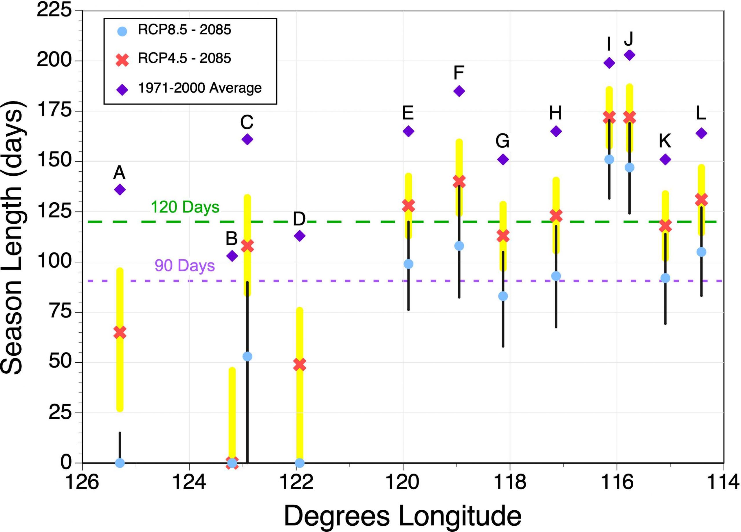
Figure 5 describes the change change in ski season length with future climate change. Ski season length generally increases inland because of colder temperatures (continentality). Under best-case scenario (RCP4.5) ski season will shrink by 27-45 days for interior resorts and 53-103 days for coastal resorts. Cypress no ski season under RCP4.5. Under worst-case scenario (RCP8.5) ski season will shrink by 48-77 days for interior resorts and 103-136 days for coastal resorts. Cypress, Mt. Washington, and Sasquatch will have no ski season under RCP8.5.


Figure 5. Historic and future forecasted changes in the length of the ski season for twelve selected ski resorts in western Canada. In this calculation, the threshold daily mean temperature for the start and end of the ski season is 0°C. Values displayed are based on data generated by ClimateBC or ClimateNA for the mid-elevation of each ski resort. Purple diamond = 1971-2000 average; red X = average of 15 climate models, RCP4.5 emission scenario, year 2085; and light blue dot = average of 15 climate models, RCP8.5 emission scenario, year 2085. Error bars for future model predictions (yellow for RCP4.5 and black for RCP8.5) are equal to one standard deviation.


In conclusion, human caused climate change in the near future is predicted to result in warmer winter temperatures, changes in snowfall and a decline in the length of the ski season for the alpine ski resorts of western Canada. How detrimental these changes will be to the ski industry in western Canada depends on whether governments can implement meaningful reductions in the future emissions of greenhouse gases.

References

Knutti, R., D. Masson and A. Gettelman. 2013. Climate model genealogy: Generation CMIP5 and how we got there. Geophysical Research Letters 40: 1194-1199.

Wang, T., A. Hamann, D. Spittlehouse and C. Carrol. 2016. Locally downscaled and spatially customizable climate data for historical and future periods for North America. PLos ONE 11(6) doi:10.1371/journal.pone.0156720.