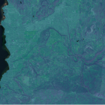
Okay so I came back and looked at the recommended BreachLeastCostDepressions tool from Whitebox. When I ran it previously I did not understand what “dist” was. For a full explanation by Dr. John Lindsay himself, check out this post. In…
Okay so I came back and looked at the recommended BreachLeastCostDepressions tool from Whitebox. When I ran it previously I did not understand what “dist” was. For a full explanation by Dr. John Lindsay himself, check out this post. In…
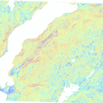
As a recap, I am currently making my way through a long list of parameters that I am interested in for mapping wetlands. These parameters are to be calculated from the raw lidar data (.laz files) or from the Digital…