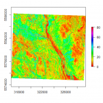
In my last post I briefly mentioned a few broad datasets I will be using: Multispectral data, radar, and LiDAR. I will begin my quest to making a predictive wetland map by digging into the LiDAR data since it will…
In my last post I briefly mentioned a few broad datasets I will be using: Multispectral data, radar, and LiDAR. I will begin my quest to making a predictive wetland map by digging into the LiDAR data since it will…

First of all, what even is a wetland? It seems there is not a universally agreed-upon definition; however, it is generally understood that a wetland is where a terrestrial ecosystem meets an aquatic one. If you think of a wetland…