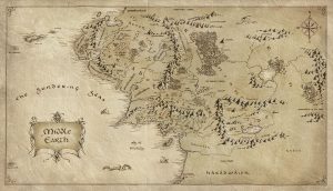
An interesting case study of how maps can generate a very realistic atmosphere within a fantastical world. The use of scale, direction, denoting mountain ranges and other sleight topography, as well as annotation all help add to the realism of this fantastic dream-made world.
Image from: http://www.majorindependence.com/map-of-middle-earth-lotr/map-of-middle-earth-lotr-10-middle-earth-map-lord-the-rings/
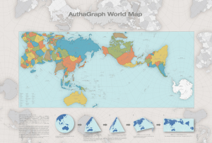
This past year the “Authagraph projection” projection map won the Good Design Award in Japan. This type of map provides significantly less distortion than the Mercator projection, and works by splitting up the earth’s surface into 96 triangulations. This type of mapping has been used in Japanese textbooks for over a decade, and was invented by Hajime Narukawa in 1999.
The most striking differences in the the Authagraph projection compared to the Mercator is the size of Africa (which is actually much larger than North America), and the apparently meager sizes of both Greenland and Antarctica.
In addition to its increased accuracy, the Authagraph projection won the award for its series of constructible maps that can be formed into cones or spheres.
Still, the map appears to possess some limitations; namely the distortion and decreased legibility of the lines of latitude and longitude, which bend and run of the boundaries of the page. Can anyone else think of limitations with the Authagraph projection? Do you believe it will be (or should be) adopted for widespread use beyond Japan?
Further reading:
‘A More Accurate World Map Wins Prestigious Japanese Design Award’ (2016)
AuthaGraph
LARC582D_URBAN REPRESENTATIONS: MAPPING_THE INVISIBLE