Turning up the heat

For my personal geography project, I attempted to expand my personal heat map of Vancouver by using Strava to track 3 of my journeys: 1 bike commute to UBC and 2 walks with my dog. I then used the “flyby” feature to find records of people that cross my journey in real time. I picked one person for each journey, marked the place where we had our “missed connection” on a map and then tried to glean what I could about their lives from their internet presence, starting from their Strava profile and then jumping into other forms of social media and other websites. Finally, I wrote each person a missed connection, using popular phrases from craigslist and dropping hints about their personal lives.

This project is about how even when we are exploring a place in the physical world, like when I am getting to know my new city by walking my dog, bike commuting and going for runs, a part of us exists online, whether we are directly sharing our route via Strava or just have an online presence in the background of our minds. It also looks at how we might meet people in person versus how we meet and “know” people online.

INTERESTING CARTOGRAPHIC ANSWER TO A LAND INVESTIGATION

Mei Fang Lao, Masters Candidate at the Bartlett School of Architecture.

PROCEDURE

Students will engage the site through a series of recordings that analyze the impact of a particular phenomena on the condition of the site. Using the assigned transects, students will track the interferences that create deflections, deviations, or deformations in the volume and/or surface of the site. Students will use a notational language of mark-making to describe the force and trace of the interferences, rather than the forms. Each student will produce an analog mapping that tracks change over time along a single transect.

For further interest go to:  http://lab.visual-logic.com/academia/la-4504-hybrid-analytical-representation/001-site-mapping/

MANY MORE DIFFERENT APPROACHES ON MAPPING IN CONTEXT TO THE ABOVE PROCEDURE AT THE BARTLETT SCHOOL OF ARCHITECTURE- TAKE A LOOK AT THE LINK FOR DIFFERENT PROJECTS.

MAPS FOR A NARRATIVE ANALYSIS

http://sigliopress.com/book/everything-sings/

That a cartographer could set out on a mission that’s so emotional, so personal, so idiosyncratic, was news to me.
—IRA GLASS, host of This American Life, from his introduction to Everything Sings.

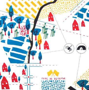
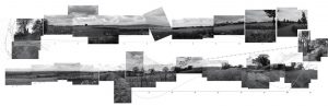
Iconoclastic geographer Denis Wood has created an atlas unlike any other. He surveys his small, century-old neighborhood Boylan Heights in Raleigh, North Carolina by first paring away the inessential (scale, orientation, street grids), then by locating the revelatory in the unmapped and unmappable: radio waves permeating the air, the paperboy’s route in space and time, the light cast by street lamps, Halloween pumpkins on porches.

His joyful subversion of the traditional notions of map making forge new ways of seeing not only this particular place, but also the very nature of place itself. In pursuit of a “poetics of cartography,” Wood makes maps in which the experience of place is primary, and the eye is attuned to the invisible, the overlooked, and the seemingly insignificant.

These maps have a traditional rigor, but they also have “fingerprints”—a gamut of subjective arguments about the relationships between social class and cultural rituals, about the neighborhood as “transformer,” about maps’ impermanence and fragility—rejecting the idea that they convey a single, static, objective truth. Together, they accumulate into a multi-layered story about one neighborhood that tells the larger, universal story of how we understand and define the places we call home.