https://decolonialatlas.wordpress.com/2016/04/12/inuit-cartography/
Geo-blog from MIT Senseable City Lab
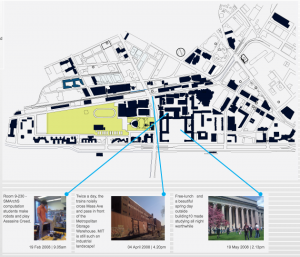
Geo-blog is a web-based platform for geo-tagging and sharing user generated content on the one hand and retrieving the shared, geo-tagged content based on current location on MIT campus at any given time on the other hand. The platform is open to MIT community for the content contribution part and open to public as a location-sensitive content viewing platform.
“Map designer Aris Venetikidis is fascinated by the maps we draw in our minds as we move around a city — less like street maps, more like schematics or wiring diagrams, abstract images of relationships between places. How can we learn from these mental maps to make better real ones? As a test case, he remakes the notorious Dublin bus map. (Filmed at TEDxDublin)”
 Follow