Statistics review
This week we reviewed statistics and regression. Since I’ve taken other GIS courses as well as a statistics course during my recent years at UBC, this lecture did not cover much material that I was not already fairly familiar with.

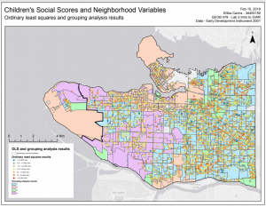
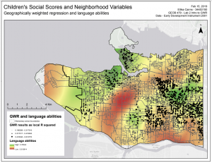
We discussed the basics of stats like methods of data summary (measures of central tendency / measures of dispersion) and regression analysis. We also discussed the differences between Ordinary Least Squares (OLS) and Geographically Weighted Regression (GWR) modelling. OLS models minimize the sum of the squares of the differences between the model and the data, and can represent the spatial process with one regression equation. If the model shows that a statistically significant relationship exists, it may be used to make predictions about future or unknown data values. GWR modelling attempts to take the variability of spatial relationships across a study region into account. The GWR model essentially creates an OLS equation for each set of grouped variables, and all the resulting regression models are analyzed together for indication of spatial variation.
So while both OLS and GWR are methods of linear regression modelling, GWR is a local model, while OLS is a global model. Studies using GWR modelling allow for the identification of “hotspots” and “coldspots”, where certain explanatory variables are significantly more or less important in relation to a dependent variable. Therefore, using GWR modelling is generally preferable over OLS models when conducting geographical studies. It produces results that better take into account real-world scenarios, and can thus often be more confidently used to make recommendations.
We also compared the results of a OLS model and GWR model in Lab 2.