Why is ‘geography’ important?
In the second week of class, we investigated why geography matters. Essentially, this can be summed up by Tobler’s First Law of Geography: “everything is related to everything else, but near things are more related than distant things”.
But of course there is more to it than that. We specifically discussed where, why, and how things happen:
- Identifying where things happen for visualization of patterns, hot spots, or clusters
- Investigating why things happen to determine processes and define places
- Analyzing how things happen and how they interact with other things
This can then allow for optimization, for example when deciding where to place a new business in a neighbourhood, or determining routes for fire departments. Context is very important here.
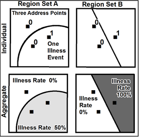
We also discussed the importance of scale, grain, and extent in a study area. Depending on the scale of analysis, results can show significantly different patterns, processes, or interactions. This brings up issues when results from a study are generalized to broader areas. For example, looking at crime rates on just one street will likely reveal vastly different patterns and processes than crime rates across an entire neighbourhood or city. The cause and meaning of these patterns and processes may also be significantly different. These issues are commonly referred to as the Modifiable Areal Unit Problem (MAUP), which is present in all spatially aggregated data. As such, choosing an appropriate scale when conducting GIS research is an important step, and potential emergent factors must be adequately addressed or acknowledged.
The grain is the minimum resolution of the data, which is defined by the scale of analysis. In raster data the grain is the cell / pixel size, and in vector data the grain is the minimum mapping unit. The mandate of the agency that collected the data may be an important factor in determining the pixel size or minimum mapping unit. Therefore it is important to choose an appropriate data source, and investigate their data collection methodology for potential error.
The extent of a study area clearly also is significant in any data analysis, since choosing an inappropriate extent will impact the results. It may be noted that “imagined” boundaries like census tracts are often not appropriate for many studies. Determining proper boundaries for a study area and incorporating buffers around the area can mitigate the impacts of edge effects.
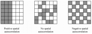
We also investigated spatial autocorrelation. Not many things are perfectly randomly distributed in the real world, and as such, patterns will develop . Patterns that develop due to a response to environmental factors (like slope) are called first-order processes. Patterns that develop due to interactions between the subject matter and events (like dispersion of automobile dealers and how they cluster together to maximize potential customers), or limitations to dispersal are called second-order processes.
Overall, this week’s topic of “why is geography important?” was a good refresher for topics that I have learned about in previous GIS and geography classes. It provided me with reminders as to certain issues that should be addressed when conducting any sort of spatial analysis.