A reminder that Rare Books and Special Collections, University Archives and the Chung Collection will be closed for the Easter long weekend (Friday April 22 through Monday April 25 inclusive). Also a reminder that last Saturday was our final open Saturday for the 2010-2011 academic year- our summer hours are in effect  after the long weekend (Monday to Friday, 9-5).

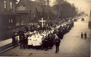
Good Friday procession, Vancouver 1914

Good Friday procession, Vancouver 1914

The image above is from the B.C. Historical Photograph Collection and depicts a Good Friday procession from the St. James Anglican Church on Cordova Street in Vancouver in 1914. It is on the front side of a postcard, produced by Timms’s Photography. St. James was established in 1881, but burned down in the Great Fire of 1886. The current building, at 303 Cordova St.,  was designed by architect Adrian Scott and opened in 1936 (see The History of Metropolitan Vancouver- 1936).

In our ongoing series of B.C. place names used in the Irving K. Barber Learning Centre, this week we will look at Fernie, B.C.  Located in the East Kootenay region of British Columbia, Fernie is nearer to Alberta than it is to the rest of the province.  Fernie’s main industry was and still is coal mining (the town is named after William Fernie, who started the coal mines in 1887) but today also includes tourism (especially skiing- Fernie made a bid for the 1968 Olympic games), transport and trade.

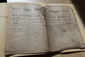
The District Ledger, 1910

The District Ledger, 1910

Our featured document is a newspaper- the District Ledger which ran under various titles from at least 1893 to 1919 (see the B.C. Archives list of microfilmed newspapers). The District Ledger was technically the newspaper of the local district of the United Mine Workers of America, but also functioned as a local newspaper and job printer for the area. RBSC holds one lonely copy of the District Ledger, dated Oct. 21, 1910. (Do you have a stack of old District Ledgers in your basement or attic? We’d love to hear from you!)

Rare Books and Special Collections collects historic newspapers from across the province (and embracing the whole alphabet, from Abbotsford to Zeballos!). Newspapers are very popular amongst researchers as a way of understanding the important issues in other communities, in other time periods. Newspaper digitization projects have frequently been funded by the BC History Digitization Program.  For help on newspapers more generally, check out UBC Library’s Newspapers research guide.

In the Barber Centre, the Fernie Reading Room is number 380, and is a study area for the use of students in the UBC Gateway Programs: Arts One, Science One, Coordinated Arts and Coordinated Science.

The Kootenay River Room, a large, bright and airy group study room (room 422) on the 4th floor of the Barber Centre, is named after the Kootenay River, one of the tributaries of the Columbia River. It is a major river that runs through southeastern British Columbia, Canada and the northern part of Montana and Idaho. Throughout the history of British Columbia, many people from various backgrounds have lived and traveled along its banks.
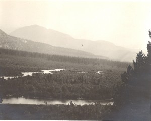
The very source of the Columbia River, looking south across Canal Flat toward the Kootenay river, ID # BC-146

The people of the Ktunaxa (Kootenai) nation have lived, fished and hunted along the river for thousands of years.
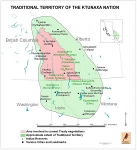
Image Credit: http://www.ktunaxa.org/who/popup_tradterritorymap.html

In the early 19th century, the first European explorer to visit the area, David Thompson, explored and surveyed the Kootenay’s banks, calling it “McGillivray’s River” on his 1814 map (the original map is in the Archives of Ontario and is part of F443, the David Thompson fonds ). Rare Books and Special Collections has a reproduction of Thompson’s 1814 map, published by the Champlain Society in 1916 : Map of the north-west territory of the province of Canada.
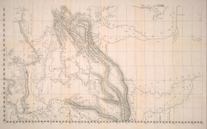
Image credit: Champlain Society Digital Collections: http://link.library.utoronto.ca/champlain/search.cfm?lang=eng

In the late 19th century, the Doukhobors, a “Spiritual Christianity” sect that originated in Russia in the late 16th-17th century and rejects organized government and the church, left Russia and travelled to Canada. Various groups settled in Manitoba, Saskatchewan and British Columbia. In 1908, the group that settled in British Columbia, called the Community Doukhobors, purchased 2,700 acres of land along the Kootenay River. Their leader, Peter Verigan, called the settlement “Brilliant,” after the sparkling waters of the river.

In Rare Books and Special Collections, there is a large body of archival material related to the Doukhobors. You may be interested in consulting the Doukhobor research collection , the Peter Faminow fonds and the Jim Hamm research collection.

In 2010, the Irving K Barber British Columbia History Digitization Program funded a digitization project by the Touchstones Nelson: Museum of Art and History, Changes Upstream: Along the Kootenay River North of the 49th Parallel Before and After the Libby Dam, 1969-72. Visit this digital exhibition to view images of the homes, lifestyles and lands of communities along the Kootenay River during the summers of 1969-72.
a place of mind, The University of British Columbia

UBC Library

Info:

604.822.6375

Renewals: 

604.822.3115
604.822.2883
250.807.9107

Emergency Procedures | Accessibility | Contact UBC | © Copyright The University of British Columbia

Spam prevention powered by Akismet