Environmental Assessment
An environmental impact assessment, or EIA, is defined by the International Association for Impact Assessment, as “the process of evaluating the potential environmental impacts of a proposed action.” An EIA is based on an interdisciplinary process intended to inform the public and decision makers of likely consequences of a proposed action in order to avoid or mitigate environmental degradation.[1] B.C.’s environmental assessment process provides a mechanism for reviewing major projects to assess their potential impacts. B.C.’s environmental assessment process is important to ensure that major projects meet the goals of environmental, economic and social sustainability.[2]
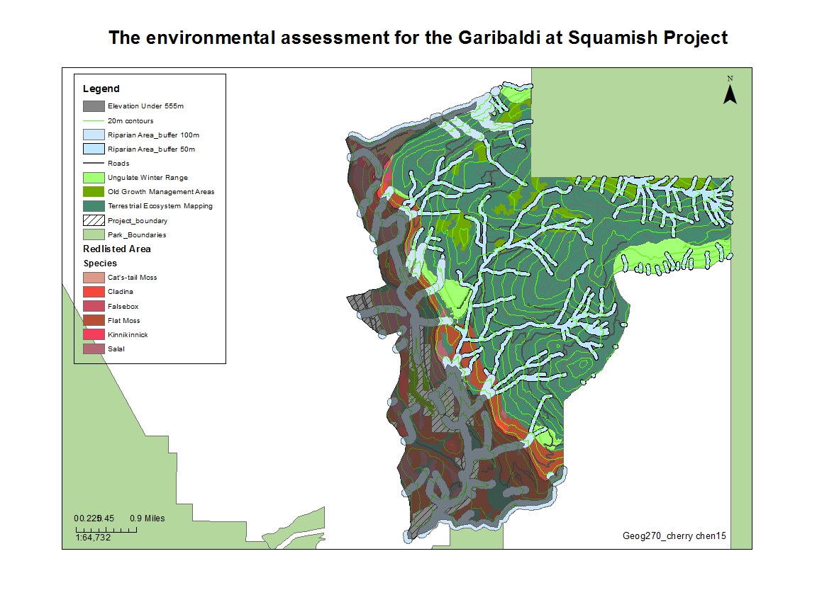
This is an environmental assessment project evaluating the planned ski resort in Garibaldi at Squamish.
Click to enlarge
Map of the environmental assessment for Garibaldi at Squamish Project
The Garibaldi at Squamish project is a proposed year-round destination resort on Brohm Ridge near Squamish. The proposed project is to develop a year-round destination resort 15km north of Squamish, and if the project is approved, there will be ski trails, lifts, resort accommodation and other commercial developments like shop…etc. As a nature resource planner, my job is to create a map and do a series of environmental impact assessment on the project to see whether this area is suitable for a resort development or not. Hence I created a map showing the project boundary, elevation indicator (below 555m of vertical), contours, roads, rivers, and the protected areas within the project boundary including:
- Old growth management areas
- Ungulate winter range
- Fishery habitats/ Riparian manage zones
- Red-listed area with each threatened ecosystems
In order to do this map, I clip all the data layers with the project boundary layer to make them clear that only showing the data with the designated area (the project boundary.) Next, I make the elevation layer (DEM layer) only showing whether the elevation is under 555m of vertical. Then I found out threatened ecosystems within the terrestrial ecosystem map (TEM layer) and indicated each one of them with different species. By doing these steps, I can analyze the data and I found out the results of protected areas that will be impacted by the project. Within the project area, about 30% of the area that is below 555m of elevation, and the results are: 6.78% of old growth management areas
- 7.90% of winter habitats of Mile Deer and Mountain Goat
- 24.82% of red-listed areas
- 30.66% of fishery habitats
that will be impacted by the proposed project and a total of 55.59% of the project area that is protected areas.
In my own opinion, this area is not suitable for building a new resort, because
too many protected ecosystems and management areas are located within the project boundary; it is more than half about 56% of the proposed project area that is protected areas. Even though 30% of the proposed area has an elevation below 555m where might get not enough snowfall that can be used to build hotels or other facilities except ski trails, but reading to the map, a huge portion of red-listed protected area is located in this area. If still building or developing on this area may lead to species extinctions due to over-developed or human impact after the development is done. The greatest two environmental concerns are red-listed areas and the fishery habitat that within the project boundary. Although the approval of the project may provide jobs and increase the total sightseeing income, but we cannot sell the cow and drink the milk, I still do not think it is a good idea to build a resort here before the two concerns got resolved and seems they are too hard to be mitigated. In the perspective of natural resource planner for BCSF, I use the map showing the environmental concerns and as evidence that there is still a long way to go before start the project; people really need to deeply think through and seriously considering the impacts before start the project.
For this project, I personally think this project is not proper enough to continue. This answer is not differ to what I wrote above in the memo when I first finished the map which means I still keep the same point of view. As the issues I mentioned in the memo, these problems make this project truly a wicked problem. Its unique and complex, too many aspects need to think about. Although building the resort may help B.C. get more tourism income, the project impacts on the environment is humongous. There is no right or wrong to this project, but just before starting it, we really need to think about the consequences and do a fully evaluation in all aspect.
Finally, the accomplishment statement for this project is that I have gained practical working knowledge of ArcMap and have learned the stages of data visualization; further more, the importance of environmental assessment projects.
Reference and resources:
[1]: By Andrea Becker. Importance of an EIA in Environmental Protection.
http://education.seattlepi.com/importance-eia-environmental-protection-3839.html
[2]: British Columbia Environmental Assessment Office. The Environmental Assessment Process
http://www.eao.gov.bc.ca/ea_process.html