On Monday, August 1, we will celebrate British Columbia (BC) Day, a civic holiday. According to the Protocol and Events Branch of the British Columbia government, the “British Columbia Day Act, R.S.B.C. 1996 c.34 was first introduced in 1974 as Bill 61 by the Hon. Ernie Hall, the Provincial Secretary under Premier Dave Barrett. The explanatory notes prefacing the bill states: “The purposes of this Bill is to recognize the pioneers of British Columbia by declaring the first Monday of August in each year to be a public holiday known as British Columbia Day.”

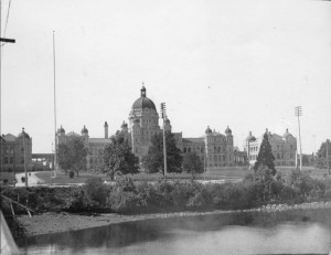
The decision to make BC a holiday was debated during the 4th session of the 30th Parliament in 1974. This debate took place in the chamber of the British Columbia Parliament building.

Image credit: Chung Collection, CC-PH-02031

Image credit: Chung Collection, CC-PH-02031

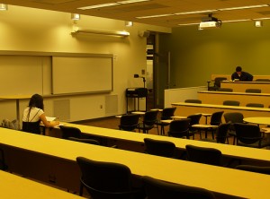
The Parliamentary Room, room 155 in the Irving K Barber Learning Centre, was modeled after this room in the British Columbia Parliament. This room is quite different from a traditional lecture hall and is intended to support collaborative student learning and debate.

Image credit: UBC Library

Image credit: Parliamentary Room, UBC Library

All of the staff in Rare Books and Special Collections wish you a happy and restful BC Day! Just a reminder that all of the UBC Library branches, including Rare Books and Special Collections, will be closed for BC Day. For more information on hours, click here.

Our featured B.C. place for this week is the northern most place we have featured yet: Atlin. The town of Atlin and Atlin Lake are located along Highway 7, not too far south of the border with Yukon. Atlin likes to be called “Switzerland of the North” because of its wintertime beauty and activities. The name Atlin is derived from the Tlingit word atlah which means “big water.”  The town was founded in the late 19th century when gold was struck in the area, drawing thousands of settlers; today the population is around 450 people.

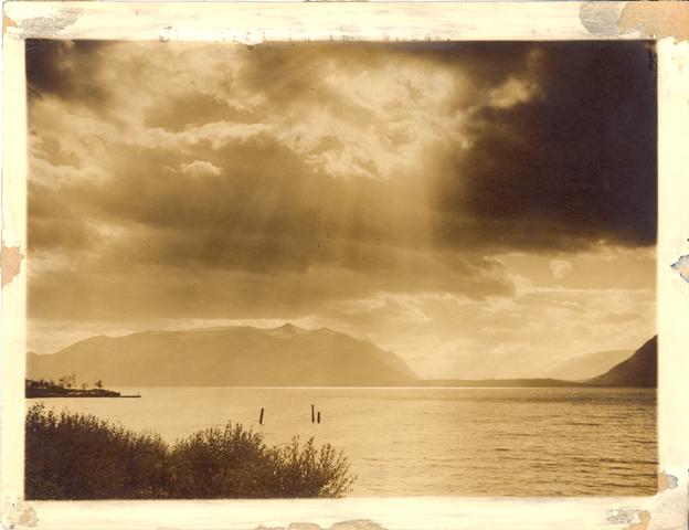
Our featured document is a photograph from our B.C. Historical Photograph Collection. It is an example of the importance of having access to the back (or verso) of some photographs, when they contain helpful inscriptions or stamps. The photograph was probably taken looking across Atlin Lake:

"Rift in the clouds", Atlin B.C.

"Rift in the clouds", Atlin B.C.

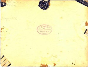
The title, “Rift in the clouds,” was inscribed on the back of the photograph, possibly by the photographer. By looking at the back, we can see the stamp of the photographer:

Verso of the photograph

Verso of the photograph

The photographer was L.C. Read, who, according to the Camera Workers of B.C., was active in the Atlin area up until around 1919.

If it were not for the photographer’s stamp on the back of the photograph,  we wouldn’t be able to say who the photographer was, and it would be unlikely that the location could be identified as Atlin.

To learn more about our historical photograph collections, consult our Photographs Research Guide. In the Irving K. Barber Learning Centre, the Atlin Meeting Room is number 191, on the first floor.

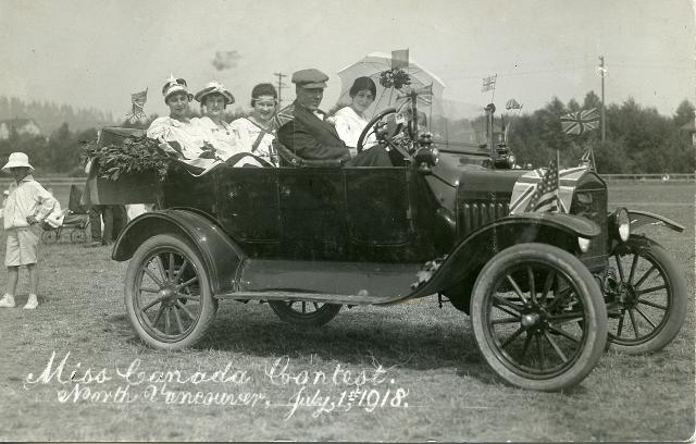
Or Dominion Day, as it was formerly known. In this photograph from RBSC’s BC Historical Photograph Collection, “Miss Canada” contestants are being driven through North Vancouver, on July 1 1918.

Miss Canada Contest, 1918

Miss Canada Contest, 1918

A reminder that all UBC Library branches (including RBSC, University Archives and the Chung Collection) are closed for Canada Day on July 1st.

For information on our historical photograph collections, check out our Research Guide for Historical Photos.

Interestingly, many of the group study rooms in the Irving K Barber Learning Centre are named after rivers in British Columbia. Room 416, a group study room on the fourth floor of the Barber Centre, is named after the Muskwa River, a river that runs 257 kilometres through northern British Columbia. The Muskwa River, a major tributary of the Fort Nelson River, flows east and north to merge with the Prophet River, before joining the Fort Nelson River.

Using some of the place name resources mentioned in the previous blog post on Keremeos, we are able to trace the different names that have been applied to the Muskwa River throughout the years; the “official” name of the river has changed a number of times since the beginning of the 20th century.

According to BC Geographical Names , on Gotfred Emile Jorgensen’s 1895 Map of the Province of British Columbia, it was labeled the “Sicannie River.” The Sikanni (Sekani) people, “dwellers of the rocks,” traded, hunted and lived near the river for hundreds of years. To read more about the history of the Sekani people of British Columbia, you may wish to read Sekani Indians of British Columbia, by Diamond Jenness.

However, what is now called the Muskwa River was labelled “Sikanni River” on BC Land’s map 1A, 1912 and then, in 1917, labeled the “Musqua River” on BC map 1H. It seems that there is some disagreement as to why the river was finally given the name Muskwa. According to George Philip Vernon and Helen Akrigg’s British Columbia Place Names, Muskwa is the Cree word for “bear.” Described by BC BookWorld as “self publishing pioneers”, the Akriggs first published their “landmark’ 1001 British Columbia Place Names in 1969; many editions followed through the years.

Other researchers believe that since the “custom apparently is for a separate band of the Sikanni Indians to hunt on [one and only one] of these rivers, […] the rivers receive the names of the leaders in each band…..thus Musquah’s River, Prophet’s River, Sikanni Chief’s River and Fantasque’s River” (BC Geographical Names http://archive.ilmb.gov.bc.ca/bcgn-bin/bcg10?name=8364).

Tracing the history of the name of the Muskwa River is a good reminder that one should consult multiple sources when doing research!

It seems appropriate in our blog series about places in British Columbia used as room names in the Irving K. Barber Learning Centre to address researching the origin of place names. There are a number of sources that are useful for researching place names, and one here at UBC is the Norman Ogg Place Name Collection (see the finding aid here).  In 1979-1980, Norman Ogg undertook a study of the origins of place names in Canada (excepting Quebec) and Washington State.  He received many letters from town and city clerks and archivists explaining the origin behind their city’s name, as well as a number of ephemeral items such as brochures.

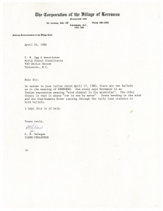
The place we are examining this week is Keremeos.  Keremeos is located in the Southern Interior of British Columbia and is in the Similkameen Valley.  The aboriginal people of this area, the Sylix, are now part of the Okanagan Nation Alliance. Horticulture and agriculture are the main industries in Keremeos, and the area is also home to Cathedral Provincial Park.  As Norman Ogg learned from the clerk of the Village of Keremeos in 1980, there are two theories behind the name Keremeos: it was believed to be derived from the Aboriginal language of the area to mean either “wind channel in the mountains” or “cut in two by water,” referring to the Similkameen River.

Letter to Norman Ogg from clerk of Village of Keremeos

Letter to Norman Ogg from clerk of Village of Keremeos

(Click on the image of the letter to see a larger version).

Other sources for place names in British Columbia include BC Geographical Names (a free online resource), The encyclopedia of raincoast place names by Andrew Scott and many other books available at UBC Library which can be browsed by subject in the catalogue.

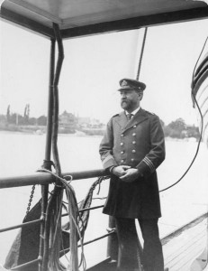
The earliest source for B.C. place names was written by Captain John Walbran, captain of the S.S. Quadra. This photograph is from the Chung Collection, which also contains a copy of Walbran’s book British Columbia Coast Names, and one of his chief officer’s logs.

Captain John Walbran, from the Chung Collection

Captain John Walbran, from the Chung Collection

As described by the Dictionary of Canadian Biography, Walbran’s Coast Names is “an amazing grab-bag of history, biography, and anecdote,” and a “rich mass of anecdotes and digressions.”  It is a well-known and well-used source of British Columbia history.

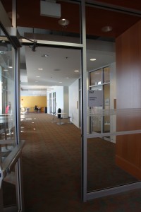
In the Barber Centre, the Keremeos Lounge is on the second floor, adjacent to Ike’s Cafe on the south side of the building. A great place to have a cup of coffee and read up on B.C. place names!

Keremeos Lounge, adjacent to Ike's Cafe

Keremeos Lounge, adjacent to Ike's Cafe

The Skeena River Room, room 317 in the Irving K Barber Learning Centre, is a group study room that is named after the Skeena River, the second-longest river entirely within British Columbia’s borders (the largest being the Fraser River). Six-hundred and twenty-one kilometers long, it flows south and west through the Skeena and Coast Mountains, reaching the Pacific Ocean at Prince Rupert.
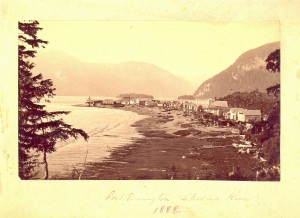
Port Essington, Skeena River, 1888, BC124

Port Essington, Skeena River, 1888, BC124

For thousands of years, the Tsimshian (“People of the Skeena”) have lived along the river; the Coastal Tsimshian live near the lower part of the river and the Gitksan live on the upper part of the Skeena River. George Vancouver visited the mouth of the Skeena River in July, 1793, but it wasn’t until the 1860s and 1870s that persons associated with the Gold Rush and railway began to travel to and settle along the river. In 1876, salmon canneries were built along the Skeena River. Operating along the river from the late 1870s to the mid-1980s, at one time there were as many as 18 canneries along the Skeena.

In Rare Books and Special Collections, we have various records and plans of salmon canneries that operated in British Columbia, and in particular along the Skeena River. For example, in the Inverness Cannery fonds, there are plans, financial records and correspondence relating to this cannery constructed along the Skeena River in 1873. The J.H Todd and Sons fonds also contains records concerning the Inverness Cannery.

It is also very interesting to consult the 1924 fire insurance plans of Skeena River salmon canneries in the collection of Plans of salmon canneries in British Columbia together with inspection reports on each, that are part of the records of the British Columbia Fire Underwriters’ Association. This collection includes the plans of 12 canneries that operated along the Skeena in the early 1920s: Inverness Cannery, North Pacific Cannery, Dominion Cannery, Sunnyside Cannery, Cassiar Cannery, Haysport Cannery, Alexandra Cannery, Balmoral Cannery, Port Essington Cannery, Carlisle Cannery, Claxton Cannery, and the Oceanic Cannery.

Fire insurance plans are detailed large-scale maps of cities, smaller municipalities, and industrial sites that were produced from the late 1800s to the mid-1960s. The object of these maps was to show the character of any insured building. These plans were compiled by the fire insurance underwriters to assist their agents in assessing and controlling the risks of fire. Various symbols and colours were used to indicate the following characteristics: the shape and size of a building; the type of construction used; the existence of fire protection facilities; and the use of the building (e.g., a restaurant, a laundry, etc.).

The fire insurance plan of the North Pacific Cannery is revealing for a number of reasons. In addition to documenting the number and types of buildings of this cannery originally established in 1889, the plan shows, for example, that in 1924, the Japanese, First Nations and Chinese cannery workers were housed in separate buildings:
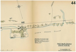
Sheet 44, North Pacific Cannery, RBSC-ARC-1272:F9-8
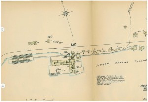
Sheet 44, North Pacific Cannery, RBSC-ARC-1272:F9-8


Sheet 44 (part 2), North Pacific Cannery, RBSC-ARC-1272:F9-8

Sheet 44 (part 2), North Pacific Cannery, RBSC-ARC-1272:F9-8
We recently had our friends from Chinese Canadian Stories (CCS) join us to host high school students from Sir Winston Churchill Secondary School for a tour of the Chung Collection and a Mandarin language lesson.  Afterward, the researchers from CCS mentioned they had found an unopened letter in the Wah Shun Company fonds– could we open it and read what was inside?

Usually when we are first processing a new archival collection we will open unopened envelopes unless there is a compelling reason not to do so (for example a privacy concern, in which case the envelope would not be made available to researchers anyway). The thinking behind this practice is that it would be better for the letter to be gently opened by an archivist than to be torn open by a well-meaning but potentially destructive patron.

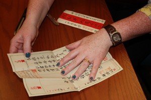
Since we had cameras on hand to document the collection tour, the CCS researchers also took photos of the letter opening.  We opened it by carefully cutting a very thin slice off the top of the envelope with a pair of scissors.  The letter is in Chinese but thankfully Joanne and Lilly from CCS  were able to read it for us- the letter was written from a Chinese man in Vancouver, to his son in China, explaining that he was going to be sending him some goods and supplies, and also giving him advice on studying hard in school. No one may ever know why the letter wasn’t sent!

Opening the letter from the Wah Shun Company fonds

Opening the letter from the Wah Shun Company fonds

The letter can be found in Box 1 folder 3 of the Wah Shun Company fonds.

The photo is courtesy of the Chinese Canadian Stories project.

This week our featured place, and Irving K. Barber Learning Centre room name,  is Hazelton.  Hazelton, as well as New Hazelton and South Hazelton, is located near where the Skeena River meets the Bulkley River, northeast of Prince Rupert.  The Hazelton area is the traditional land of the Gitxsan and Wet’suwet’en First Nations.

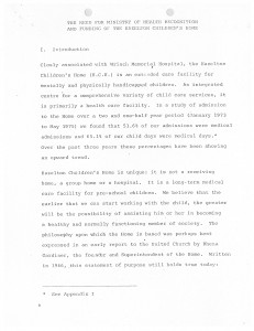
The featured document is from the Social Planning and Research Council (SPARC) of British Columbia fonds. SPARC is a non-partisan organization that was founded in 1966 to “work with communities in building a just and healthy society for all” (from the SPARC website). The archives here at RBSC include files from 1966 to 1984 and contain a wealth of information on the history of social issues and programs in B.C., from youth, housing, health, aging, and much more. One such file is on the Hazelton Children’s Home.  Founded by the United Church in 1967, the Hazelton Children’s Home appears to have run at least into the 1980’s.  It is described in the file as “an extended care facility for mentally and physically handicapped children.” The files contain a request for funding written to the Skeena Health Unit in 1978.  Information about the home is now scarce- the SPARC files as well as files at the Bob Stewart United Church Archives appear to be two of few sources.

Document from SPARC fonds

Document from SPARC fonds

A finding aid for the SPARC fonds is available, and if you are new to archival research, we recommend our Archival Materials Research Guide.

In the Barber Centre, the Hazelton Classroom is on the fourth floor in the south end of the building.

Always wanted to “go down in the history books” but not sure how? It’s easy- answer the 2011 Canadian census, and answer YES to question 10.  The census is a rich source of information for future researchers to understand ordinary Canadians. But they will only be able to see your data if you answer YES to question 10, which allows your data to be made available in 92 years, in the year 2103.

Graphic courtesy of the Association of Canadian Archivists.

The Association of Canadian Archivists is advocating for all Canadians to be aware of the implications behind question 10. Unfortunately, in the 2006 census only 56% of respondents agreed to allow their responses to be released in the year 2098.  What can you do to stop this from happening again?

  • Fill in the census form (information available on the Stats Can website if you have not received a form at your home: http://census2011.gc.ca/) and answer YES to question 10.
  • Encourage your family and friends to do the same.
  • Sign up for the Association of Canadian Archivists Facebook event to show your support.
  • Print this poster from the ACA and hang it in your workplace.

To discover the rich information held in census data, go the the Library and Archives Canada Census page. The most recent census data available is from 1911.

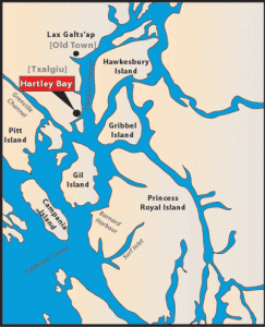
This week, we are taking a closer look at the community of Hartley Bay — the community that the Hartley Bay Meeting Room (room 266), in the Irving K Barber Learning Centre is named after.

Image Credit: Map of Hartley Bay, from http://www.gitgaat.net/place/enlargemap.htm

Hartley Bay is the home of the Gitga’at First Nation, members of the Tsimshian cultural group. A village of 200, accessible only by air or water, Hartley Bay is located at the mouth of Douglas Channel, about 630 kilometres north of Vancouver and 145 kilometres south of Prince Rupert.

On March 22, 2006, the people of Hartley Bay were the first responders to the passengers aboard the sinking BC Ferries Queen of the North. The community was recognized for their heroic actions by the Governor General on May 3, 2006 and received the Governor General’s Commendation for Outstanding Service.

The XWI7XWA LIBRARY, located at 1985 West Mall has a variety of material on the community of Hartley Bay, including material in their special collections. Contact Ann Doyle, head of XWI7XWA LIBRARY, for more information on accessing material in the special collections.

a place of mind, The University of British Columbia

UBC Library

Info:

604.822.6375

Renewals: 

604.822.3115
604.822.2883
250.807.9107

Emergency Procedures | Accessibility | Contact UBC | © Copyright The University of British Columbia

Spam prevention powered by Akismet