Mapping Support’s 2017 USA Congressional District Map uses GIS with Google to highlight current gerrymandered electoral districts in the US (the interactive map is worth checking out). In some states politicians (as opposed to independent or judiciary groups) redraw voting districts to compose an electoral district that would align in the incumbents’ favor. The map above is a district that dilutes urban (more likely minority and democratic-leaning) voters with suburban and rural voters (more likely white and republican). Not surprisingly, these maps are contentious. The US Supreme Court has ruled earlier this month that districts drawn in republican controlled North Carolina are based on race and therefore unconstitutional. The Court will also hear another important trial in which the justices may finally clearly lay out the limits of gerrymandering. The NYTimes puts it more eloquently in an editorial why politicians shouldn’t make maps.
Here’s a great website that allows NYC residents to record a video from their block and to geotag it to a map of the city. The majority of the vides were created by students in middle school and high school.
The site was exhibited at the MOMA as part of their “Talk To Me” exhibition in 2012, and was later included in the USA pavilion at the Venice Biennale in ‘Spontaneous Interventions‘.
I found the website to be a really fascinating as a way to look into the city’s often unexplored boroughs, including Staten Island and Queen’s.
Infinitely continuous patterns generated by mathematical equations. These can be rendered by a computer to show forms that always existed in nature but had previously always been invisible. https://en.wikipedia.org/wiki/Fractal
If you are able to get/track down a copy of the May 2017 issue of Landscape Architecture Magazine, the article “132 High Fidelity” by Karl Kullmann provides some interesting commentary about how “drone mapping is reorienting designers’ relationship to the aerial view.”
An awesome website that I came across that has a collection of interesting city maps, as well as informational maps of that city based on crime, location, traffic et cetera. Definitely a site worth checking out.
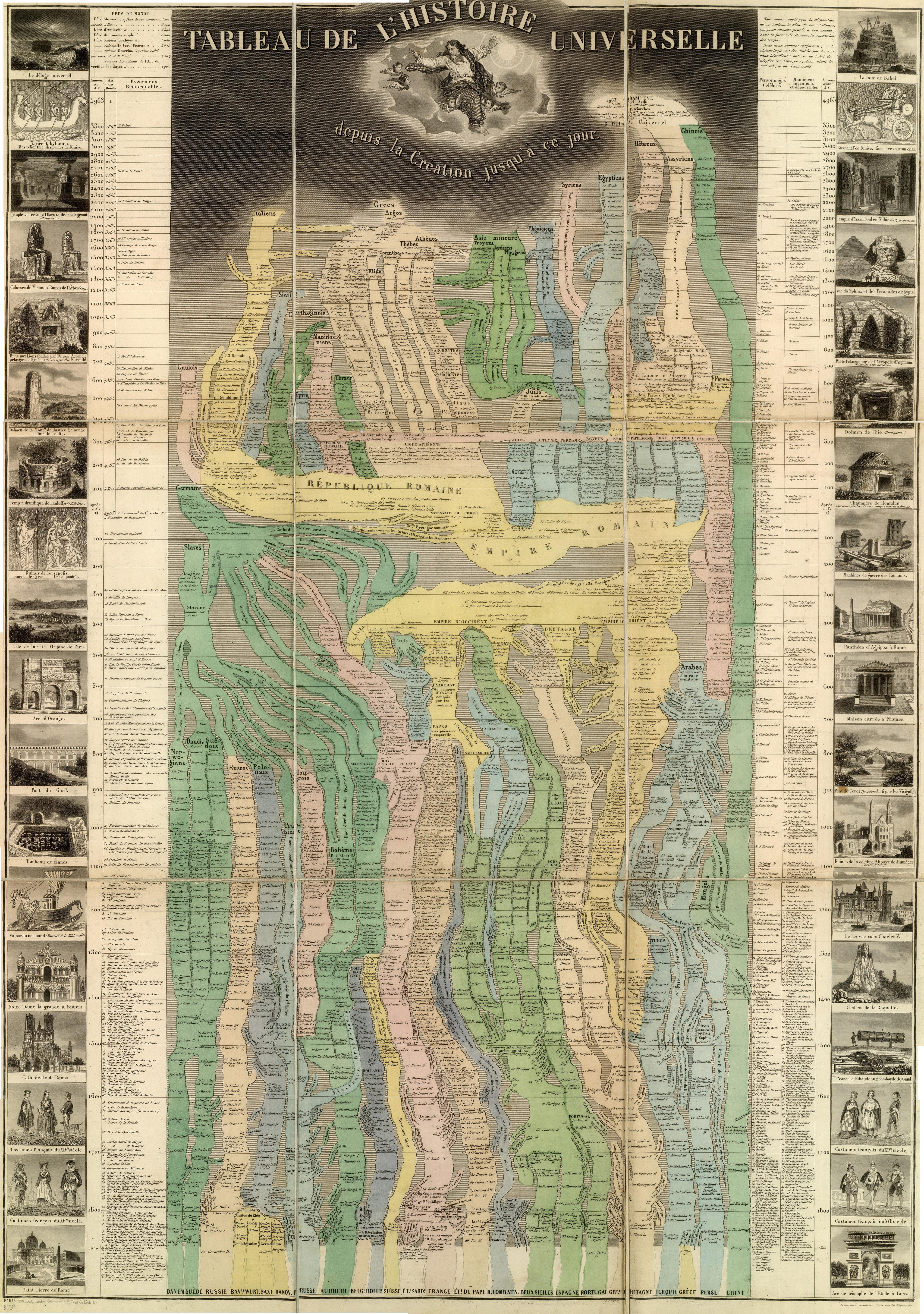
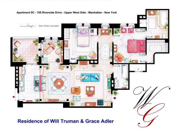
Iñaki Aliste Lizarralde draws floor plans from famous TV apartments, creating real-world maps of fictional settings. His drawing of the “Friends” apartment is part of the You Are Here: NYC collection, and many of his other maps represent New York as well. For example, he has done drawings of the apartments of Carrie Bradshaw, Holly Golightly, Will & Grace and Lucy & Ricky, all set in New York but never truly existing within the city. These sets were mostly created in Los Angeles (with exception of the apartments of Bradshaw and Golightly, which were created on stage in New York), but are nevertheless an integral part of the populace’s perception of the city of New York.
This emphasis on the New York setting leads me to think of how Vancouver does not have a single map like this, despite being a filmmaking hub. Instead maps are made of the other places in the world that Vancouver represents on screen – like the video, “Vancouver Never Plays Itself.” This video visually maps many of the places Vancouver has pretended to be and is an interesting contrast to Lizarralde’s New York floor plans.
What does the world look like when you map it using data? Social geographer Danny Dorling invites us to see the world anew, with his captivating and insightful maps that show Earth as it truly is — a connected, ever-changing and fascinating place in which we all belong. You’ll never look at a map the same way again.
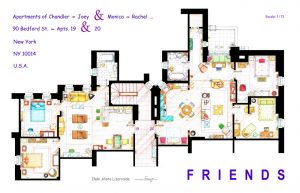
“As more and more examples of classic Brutalism face demolition by neglect, we hope that putting these examples of D.C.’s Brutalist architecture on the map will foster public appreciation that ensures their longevity, said Madsen. “
City Guide publisher Blue Crow Media and Deane Madsen, Associate Editor of Design at Architect Magazine, have collaborated to produce the Brutalist Washington Map, which features 40 examples of Brutalist architecture in Washington, D.C. This is Blue Crowe’s fourth architectural guide map, following their Brutalist London Map, Art Deco London Map, and Constructivist Moscow Map. One can only expect further releases on the horizon.
For further reading and interest of this article please reach the link below.
Let’s visit the link below. You can find many interesting subjects of these maps and they may be helpful to you to extend your imagination beyond the regular topics of mapping.
